Maps of Highland

Scotland.
1 : 2400000 Bowen, Frances
Scotland (with) inset map of the Shetland Islands.
1 : 2027520 Tallis, J. & F.
Scotland.
1 : 4000000 Fenner, Rest.
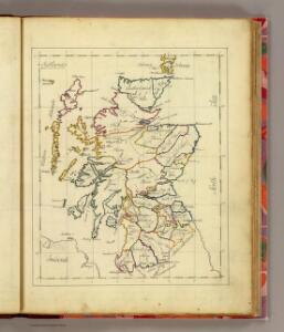
Scotland.
1 : 2250000 Carey, Mathew
Scotland.
1 : 2534400 Lucas, Fielding Jr.
Scotland.
1 : 2250000 Carey, Mathew
Scotland
1 : 785000 Orkneje (Skotsko) George Philip & Son
A New and Correct Mercator Map of Northern Britain [or Scotland]
During the Jacobite Rising, the English forces, led by George II’s son, William, Duke of Cumberland pursued Bonnie Prince Charlie's army back across the Scottish border. They arrived at Edinburgh at the end of January 1746, and then ventured north to Aberdeen. The Jacobites fled further north, but Cumberland was in no mood to hurry after them. He was acutely aware of the difficulty of moving troops through the Highland terrain, where roads were few and opportunities for ambush many. The most up-to-date map of Scotland available to both the English and the Jacobite sides was this map by John Elphinstone, a military engineer who served with the Duke of Cumberland's army. Though it was drawn in 1745, and was a great improvement on earlier maps, it nonetheless attracted criticism for its inaccuracies. Elphinstone's depiction of hills, for example, is entirely schematic with none of the detail necessary to thread a route between Highland glens or plan military offensives. Cumberland realised his lack of local topographical knowledge would put the English at a serious disadvantage. He spent the next two months acquiring what information he could about the lie of the land and training his troops for the particular type of campaign they would be forced to fight. Elphinstone's map was engraved by Thomas Kitchen, who worked in London's Holborn, and published by Andrew Millar in the Strand. Copies of the map were sold for 1s 6d. This one has been coloured by hand to indicate the territories of the Highland clans. Elphinstone, John Kitchin, Thomas
Scotland or N. Britain.
1 : 1500000 Bowen, Emanuel
Composite: Scotland or North Britain.
1 : 447000 Campbell, Robert, Lieutenant
Scotland.
1 : 610000 Hughes, William

North Britain or Scotland divided into its counties
1 : 800000 Skotsko Kitchin, Thomas Faden, William Wm. Faden
Ancient Britain II.
1 : 1830000 Society for the Diffusion of Useful Knowledge (Great Britain)
Scotland ancient, modern.
1 : 2200000 Patteson, Edward
Scotland (outline)
1 : 2200000 Patteson, Edward
Composite: Scotland.
1 : 700000 Lizars, Daniel
Scotland.
1 : 1500000 Colton, G.W.
Andrews's new and accurate travelling map of the roads of Scotland, shewing the distances between the towns &c.
1 : 1
New and correct map of Scotland & the Isles.
1 : 2100000 Moll, Herman, d. 1732
BRITANNICARUM INSULARUM VETUS DESCRIPTIO - Scotland
This map of the British Isles is the work of Abraham Ortelius. It dates from 1590 and was published in Antwerp. It appears in the forth Additamentum to Ortelius's Theatrum Orbis Terrarum. Ortelius published these 'additions' to supplement editions of his atlas. The fourth Additamentum contained, in addition to new, more modern maps, a section devoted to classical history known as the Parergon. It is in this section that this map resides. Here the northern and southern parts of the British Isles are shown with British tribes, Roman town names and other information according to classical traditions. For this new map Ortelius has based the outline of England and Wales on that of Christopher Saxton, which portrayed the proportions of the land mass more accurately than before, with Ireland and Scotland remaining the same as the existing maps in the atlas. It is likely that the engraving was by Jan Wierix. Ortelius, Abraham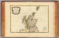
Ecosse.
1 : 2400000 Bonne, Rigobert, 1727-1794
Composite: Scotland.
1 : 450000 Robert Laurie & James Whittle
Das Königreich Scotland
1 Karte : Kupferdruck ; 20 x 27 cm Reilly F. J. J. von Reilly
Karte von Scotland
1 Karte : Kupferdruck ; 54 x 50 cm Schrämbl; Dorret; Stenger zu finden in eigenem Verlage Schrämbl
L'Escosse royaume
1 Karte : Kupferdruck ; 39 x 49 cm Sanson; Fortin chez Fortin ing.r mécanicien du roi pour les globes rue de la Harpe près celle du Foin
A new [and] accurate map of Scotland or North Britain
1 Karte : Kupferdruck ; 41 x 34 cm Bowen s.n.
A correct map of Scotland from new surveys
1 Karte auf 2 Blättern : Kupferdruck ; 75 x 59 cm Dorret s.n.
L'Escosse royaume
1 Karte : Kupferdruck ; 39 x 50 cm Sanson; Mariette chez Pierre Mariette rue St. Iacques a l'esperance