Maps of Lower Bavaria

Bayern IV.
1 : 650000 Radefeld, Carl Christian Franz, 1788-1874
Electoratvs Bavariae compendiosa delineatio
1 Karte : Kupferdruck ; 17 x 18 cm Finkh s.n.
Sacri imperii Romani circuli et electoratus Bavariæ, 4
1 Karte : mehrfarbig ; R. et J. Ottens
Des Herzogthums Oberbayern Pfleggerichte Neuötting, Mörmosen, Craiburg, Cling, Trosburg, Julbach und die Herrschaften Hohenaschau und Wildenwart oder das Rentamt Burghausen
1 Karte : Kupferdruck ; 22 x 26 cm Reilly F. J. J. von Reilly
Bavaria dvcatvs
1 : 765000 Mollova mapová sbírka Merian, Matthaeus Merian, Matthäus
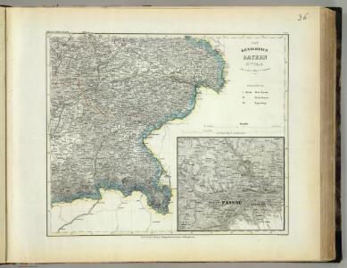
Charte von königlich Bayerschen Kreise der Unterdonau
1 : 360000 Bavorsko (Německo) Blume Aug. Kneisel
Bavariae pars inferior
1 Karte : Kupferdruck ; 46 x 56 cm Homann Johann Baptist Homann
Bavariæ pars inferior
1 Karte : Kupferdruck ; 47 x 56 cm Seutter Matthäus Seutter
Bavariae pars inferior tam in sua regimina generalia quam in eorundem praefectvras particvlares accurate divisa
1 : 318000 Bavorsko (Německo) Homann, Johann Baptist excudente Ioh. Baptista Homanno
Bavariae pars inferior tam in sua regimina generalia quam in eorundem praefecivras particvlares accurate divisa
1 : 318000 Bavorsko (Německo) Homann, Johann Baptist Johann Baptist Homann
Bavariae pars inferior tam in sua regimina generalia quam in eorundem praefecivras particvlares accurate divisa
1 : 318000 Bavorsko (Německo) Homann, Johann Baptist Johann Baptist Homann
Bavariae pars inferior tam in sua regimina generalia quam in eorundem praefecivras particvlares accurate divisa
1 : 318000 Bavorsko (Německo) Homann, Johann Baptist Johann Baptist Homann
Sacri Imperii Romani Circuli et Electoratus Bavariae cum Finitimis Geographica Descriptio. Cum Privilegio D.D. Ordinum Generalium ut et Hollandiae West Frisiaequae]
1 : 270000 Mollova mapová sbírka Valck, Leonardus

Bavaria Dvcatvs
1 : 780000 Mollova mapová sbírka Merian, Matthaeus Merian, Matthäus
Des Herzogthums Niederbayern Pfleggerichte Aerding, Dorfen, Neumarkt, Vils=Biburg, Geisenhausen, Teisbach, Dingelfing, Reisbach, Gænkofen, Eggenfelden, Landau, Pfarrkirchen, Griesbach, Vilshofen, Osterhofen, Nadernberg, Kirchberg, Rottenburg, Mosburg und die Grafschaft Hals und Herrschaft Eckmühl oder das Rentamt Landshut mit der Grafschaft Ortenburg
1 Karte : Kupferdruck ; 21 x 34 cm Reilly F. J. J. von Reilly
Sacri Romani imperii circuli et electoratus Bavariae tabula, 6
6 Blätter : s.n.

Bavariae pars inferior
1 : 320000 Horní Bavorsko (Německo) Seutter, Matthäus sumtibus Matthaei Seutter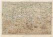
Karte der Salzburger-Alpen und des Salzkammerguts
1 : 250000 Salcburské Alpy (Rakousko : pohoří) Ravenstein, Ludwig L. Ravenstein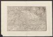
Militair Karte von Süd-Deutschland in 20 Sectionen
1 : 400000 11. Section Coulon, Alois von A. von Coulon
Regensburg 130, uit: Special-Karte von Mittel-Europa / nach amtlichen Quellen bearbeitet von W. Liebenow
1 : 300000 titelvariant: W. Liebenow's Mittel-Europa; Annotatie: Titel boven de bladen: W. Liebenow's Mittel-Europa Johannes Wilhelm Liebenow 1822-1897 Frankfurt a. M. : Ludwig Ravenstein
Salzburg 144, uit: Special-Karte von Mittel-Europa / nach amtlichen Quellen bearbeitet von W. Liebenow
1 : 300000 titelvariant: W. Liebenow's Mittel-Europa; Annotatie: Titel boven de bladen: W. Liebenow's Mittel-Europa Johannes Wilhelm Liebenow 1822-1897 Frankfurt a. M. : Ludwig Ravenstein
Carte topographique d'Allemagne contenant une grande partie de l'electorat de Baviere, de l'eveché de Freisingengen
1 Karte : Kupferdruck ; 45 x 62 cm Jaeger se vend chez l'auteur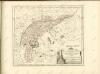

Salzburg
1 : 200000 Herder, Benjamin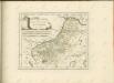

Das Herzogthum Ober und Nieder Baiern, 4
1 Karte : 43 x 55 cm Lotter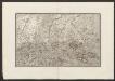
Militair Karte von Süd-Deutschland in 20 Sectionen
1 : 400000 15. Section Coulon, Alois von A. von Coulon