Maps of India

Hindostan.
1 : 9000000 Colton, G.W.
India.
1 : 8400000 Sharpe, J.
Vorder Indien
1 : 6360000 entworfen und gezeichnet von C. F. Weiland Weimar : Verlag des Geograph. Instituts
Hindostan.
1 : 17200000 Bowen, Frances
Hindostan mit einem Theile des Birmanischen Reichs
Stieler's Hand-Atlas Stieler, Adolf bei Justus Perthes
Hindostan.
1 : 12672000 Burr, David H., 1803-1875
Karte vom Kriegsschauplatz in Ostindien
1 : 9500000 gezeichnet v. T. Koenig Berlin : R. Wagner
Carte de la Inde
1 : 9300000 Herbin de Halle, Etienne de.
India.
1 : 8553600 Letts, Son & Co.
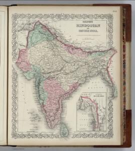
Hindostan Or British India.
1 : 9000000 Colton, G.W.
Hindoostan or British India.
1 : 9000000 Colton, G.W.
Inner-Asien & Indien
1 : 7500000 Bangladéš Petermann, August Lüddecke, Richard Justus Perthes
Hindoostan or India.
1 : 20000000 Seaman, James V.
India, 34
1 : 8500000 Appleton, D. & Co.
Volker-Karte der Indischen Welt.
1 : 9400000 Berghaus, Heinrich
93-94. India.
1 : 7500000 Touring club italiano
Hindoostan.
1 : 15000000 Tanner, Henry S.
Vorder Indien
Bhútán Steinhauser, Anton Artaria
[Vorder-Indien oder Ango-Indische Reich]
Hand-Atlas über alle Theile der Erde und über das Weltgebäude Stieler, Adolf Justus Perthes
Density of the population in Peninsular India

Vorder-Indien
Neuer Handatlas über alle Theile der Erde Kiepert, Heinrich Verlag von Dietrich Reimer
Hindostan or India.
1 : 9000000 Carey, Mathew
Map of Hindostan or India.
1 : 9500000 Carey, Mathew
Hindostan or India.
1 : 14572800 Carey, Mathew
Map of Hindostan or India.
1 : 10264320 Carey, Mathew
Map of Hindostan or India.
1 : 10264320 Carey, Mathew
Hindoostan.
1 : 14600000 Darton, William
Vorder Indien.
1 : 6100000 Weiland, C. F. (Carl Ferdinand), d. 1847
Vorder - Indien