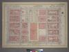
Maps of Queens County
Pl. 20: wards 19-22.
1 : 1800 Bromley, George Washington; Bromley, Walter Scott
Part of Sections 3, 4 & 5 : New York City.
from Atlas of the city of New York, Manhattan Island. From actual surveys and official plans / by George W. and Walter S. Bromley.
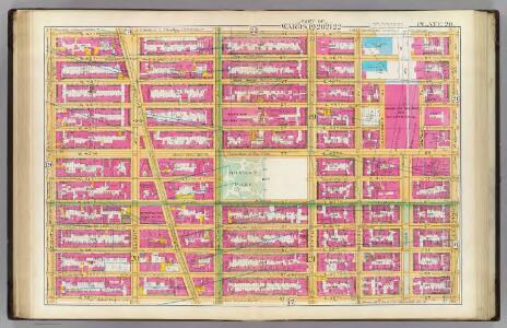
[Plate 20: Bounded by W. 47th Street, E. 47th Street, Lexington Avenue, E. 36th Street, W. 36th Street, and Eighth Avenue.]
from Atlas of the city of New York, borough of Manhattan. From actual surveys and official plans / by George W. and Walter S. Bromley.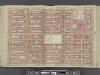
Manhattan, Double Page Plate No. 20 [Map bounded by W. 47th St., Lexington Ave., W. 36th St., 8th Ave.]
From Atlas of the city of New York, Manhattan Island. From actual surveys and official plans
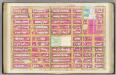
Part of Sections 3 , 4 & 5 : Plate 66.
from Atlas of the borough of Manhattan, city of New York.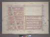
Plate 26, Part of Sections 3,4&5: [Bounded by W. 42nd Street, Fifth Avenue, W. 37th Street and Seventh Avenue.]
from Atlas of the city of New York, borough of Manhattan. From actual surveys and official plans / by George W. and Walter S. Bromley.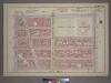
Plate 26, Part of Sections 3,4&5: [Bounded by W. 42nd Street, Fifth Avenue, W. 37th Street and Seventh Avenue.]
from Atlas of the city of New York, borough of Manhattan. From actual surveys and official plans / by George W. and Walter S. Bromley.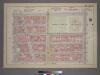
Plate 26, Part of Sections 3,4&5: [Bounded by W. 42nd Street, Fifth Avenue, W. 37th Street and Seventh Avenue.]
from Atlas of the city of New York, borough of Manhattan. From actual surveys and official plans / by George W. and Walter S. Bromley.
[Plate 72: Bounded by W. 47th Street, Fifth Avenue, W. 42nd Street, and Broadway.]
from Atlas of the borough of Manhattan, city of New York.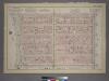
Plate 31, Part of Sections 4&5: [Bounded by W. 47th Street, Fifth Avenue, W. 42nd Street and Seventh Avenue.]
from Atlas of the city of New York, borough of Manhattan. From actual surveys and official plans / by George W. and Walter S. Bromley.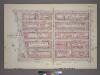
Plate 31, Part of Sections 4&5: [Bounded by W. 47th Street, Fifth Avenue, W. 42nd Street and Seventh Avenue.]
from Atlas of the city of New York, borough of Manhattan. From actual surveys and official plans / by George W. and Walter S. Bromley.
Manhattan, V. 4, Double Page Plate No. 81 [Map bounded by West 47th St., East 47th St., Vanderbilt Ave., East 42nd St., West 42nd St., 6th Ave.]
From Atlas 113. Vol. 4, 1899.
Manhattan, V. 4, Double Page Plate No. 81 [Map bounded by W. 47th St., E. 37th St., Park Ave., E. 42nd St., W. 42nd St., 6th Ave.]
From Atlas 42.54. Vol. 4, 1890.
Plate 31, Part of Sections 4&5: [Bounded by W. 47th Street, Fifth Avenue, W. 42nd Street and Seventh Avenue.]
from Atlas of the city of New York, borough of Manhattan. From actual surveys and official plans / by George W. and Walter S. Bromley.
Manhattan, V. 4, Double Page Plate No. 78 [Map bounded by West 42nd St., East 42nd St., Park Ave., East 37th St., West 37th St., 6th Ave.]
From Atlas 113. Vol. 4, 1899.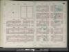
Manhattan, V. 4, Double Page Plate No. 78 [Map bounded by W. 42nd St., E. 42nd St., Park Ave., E. 37th St., W. 37th St., 6th Ave.]
From Atlas 42.54. Vol. 4, 1890.
[Plate 86: Map bounded by West 42nd Street, East 42nd Street, Fourth Avenue, East 37th Street, West 37th Street, Sixth Avenue.]
from Maps of the city of New York / surveyed under directions of insurance companies of said city.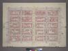
Plate 25, Part of Sections 3&5: [Bounded by E. 42nd Street, Third Avenue, E. 37th Street and Fifth Avenue.]
from Atlas of the city of New York, borough of Manhattan. From actual surveys and official plans / by George W. and Walter S. Bromley.
Plate 81: Map bounded by West 47th Street, East 47th Street, Fourth Avenue, East 42nd Street, West 42nd Street, Sixth Avenue
from Maps of the city of New York.
Part of Sections 3 , & 5 : Plate 67.
from Atlas of the borough of Manhattan, city of New York.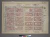
Plate 25, Part of Sections 3&5: [Bounded by E. 42nd Street, Third Avenue, E. 37th Street and Fifth Avenue.]
from Atlas of the city of New York, borough of Manhattan. From actual surveys and official plans / by George W. and Walter S. Bromley.
Plate 78: Map bounded by West 42nd Street, East 42nd Street, Fourth Avenue, East 37th Street, West 37th Street, Sixth Avenue
from Maps of the city of New York.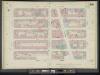
Manhattan, V. 5, Double Page Plate No. 94 [Map bounded by W. 42nd St., 6th Ave., W. 37th St., 8th Ave.]
From Atlas 42.55. Vol. 5, 1890.
Part of Section 5: Plate 73.
from Atlas of the borough of Manhattan, city of New York.
Plate 94: Map bounded by West 42nd Street, Sixth Avenue, West 37th Street, Eighth Avenue
from Maps of the city of New York.
[Plate 96: Map bounded by West 42nd Street, Sixth Avenue, West 37th Street, Eighth Avenue.]
from Maps of the city of New York / surveyed under directions of insurance companies of said city.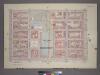
Plate 32, Part of Section 5: [Bounded by E. 47th Street, Third Avenue, E. 42nd Street and Fifth Avenue.]
from Atlas of the city of New York, borough of Manhattan. From actual surveys and official plans / by George W. and Walter S. Bromley.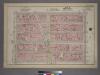
Plate 21, Part of Section 3: [Bounded by (W. 37th Street, Fifth Avenue, W. 32nd Street and Seventh Avenue.]
from Atlas of the city of New York, borough of Manhattan. From actual surveys and official plans / by George W. and Walter S. Bromley.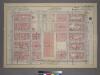
Plate 32, Part of Section 5: [Bounded by E. 47th Street, Third Avenue, E. 42nd Street and Fifth Avenue.]
from Atlas of the city of New York, borough of Manhattan. From actual surveys and official plans / by George W. and Walter S. Bromley.