Maps of Denmark

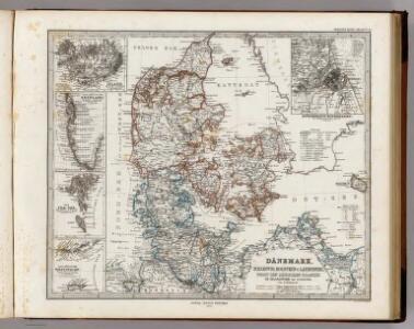
Danemark, Schleswig, Holstein u. Lauenburg, Nebst Den Danischen Colonie'n.
1 : 1500000 Petermann, A.
Dänemark, Schleswig, Holstein u. Lauenburg, nebst den Dänischen Colonien
Hand-Atlas über alle Theile der Erde und über das Weltgebäude Stieler, Adolf Justus Perthes
[Dänemark und die Dänischen Kolonien]
Handatlas über alle Theile der Erde und über das Weltgebäude Stieler, Adolf Justus Perthes
Regni Daniae Novißima et Accuratißima Tabula
1 : 1100000 Mollova mapová sbírka Visscher, Nicolaes Visscher, Nicolaus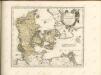

Carte du royaume de Danemarc
1 : 1000000 Dánsko Delisle, Guillaume Iean Covens et Corneille Mortier
Das Königreich Daenemark
1 : 1090000 Dánsko Weiland, Karl Ferdinand Geographischen Institut
Das Königreich Daenemark
1 : 1090000 Dánsko Weiland, Karl Ferdinand Maedel, A. Geograph. Institut
Daenemarck.
Dánsko Güssefeld, Franz L. Mollo, Tranquillo Tranquillo Mollo
Daenemarck
1 : 1260000 Bornholm (Dánsko) Mollo, Tranquillo Tranquillo Mollo
Daenemarck
1 : 1245000 Dánsko Tranquillo Mollo
Daenemarck.
Dánsko Güssefeld, Franz L. Mollo, Tranquillo Tranquillo Mollo
Daenemark, Island.
1 : 875000 Weiland, C. F. (Carl Ferdinand), d. 1847

Karte von dem Koenigreiche Daenemark
1 : 1000000 Dánsko Reilly, Franz Johann Josef von Franz Ioh. Ios. von Reilly
DANIA | REGNVM.
[Amsterdam : Joan Blaeu]
Das Königreich Daenemark
1 : 1090000 Dánsko Weiland, Karl Ferdinand Geographisches Institut
Daniae Reg. cum Ducatu Holsatiae et Slesvici
1 : 500000 Weyerman, Jacob Campo
Daniae regnum cum ducatu Holsatiae et Slesvici nec non insulae Danicae et Iutia cum parte Scaniae
1 : 941000 Dánsko Lotter, Tobias Conrad studio Tobiae Conradi Lotteri
Pas-Caarte van't Schager-Rack, De Sondt en de Belt. [Karte], in: De Nieuwe Groote Vermeerderde Zee-Atlas ofte Water-Werelt, S. 21.
1 Karte aus Atlas Doncker, Hendrick
Regni Daniae accuratissima delineatio
1 : 1150000 Dánsko Wit, Frederick de Frederick de Witt
Daniae Regnum [Karte], in: Atlas, sive, Cosmographicae meditationes de fabrica mundi et fabricati figura, S. 135.
1 Karte aus Atlas Mercator, Gerhard
Regni Daniae
1 : 1129000 Dánsko Visscher, Nicolaus per Nicolaum Visscher
REGNI DANIAE, Novißima et accuratißima TABULA
1 : 1130000 Dánsko Visscher, Nicolaus per Nicolaum Visscher
Homannův atlas světa
1 : 930000
[DANIA REGNUM in quo sunt ducatus HOLSATIA et SLESVICUM INSULAE DANICAE et PROVINCIAE IUTIA, SCANIA, BLEKINGIA ET HALLANDIA]
1 : 1050000 Dánsko Wit, Frederick de F. de Wit
Daniae Regnum [Karte], in: Gerardi Mercatoris et I. Hondii Newer Atlas, oder, Grosses Weltbuch, Bd. 1, S. 103.
1 Karte aus Atlas Mercator, Gerhard und Hondius, Jodocus Jansson, Jan
Regni Daniae Accuratissima delineatio. [Karte], in: Novus atlas absolutissimus, Bd. 1, S. 116.
1 Karte aus Atlas Janssonius Offizin
Das Königreich Daenemark nebst seinen Nebenlaendern in Europa
1 : 1100000 entworfen und gezeichnet von C.F. Weiland Weimar : Verlag des Geographischen Instituts
Regni Daniae in quo sunt ducatus Holsatia et Slesvicum insulae Danicae provinciae Iutia Scania Blekingia nova tabula
1 : 1100000 Dánsko Homann, Johann Baptist
Regni Daniae, in quo sunt ducatus Holsatia et Slesvicum, insulae Danicae, provinciae Iutia Scania Blekingia etc. nova tabula
1 : 1100000 Dánsko Homann, Johann Baptist â Io. Baptista Homanno
Regni Daniae, in quo sunt ducatus Holsatia et Slesvicum, insulae Danicae, provinciae Iutia Scania Blekingia etc. nova tabula
1 : 1100000 Dánsko Homann, Johann Baptist â Io. Baptista Homanno