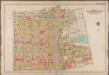
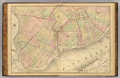
Maps of Kings County
Sec. 1. Brooklyn map.
1 : 6000 Fulton, Henry; J.B. Beers & Co.
A map of the village of Williamsburgh, Kings County, N.Y. : showing each lot of ground in said village, as laid down on the assessment of the village, together with the assessment number of each lot / made by Isaac [V]ieth, under the supervision of Henry
from Brooklyn
Map of the City of Williamsburg and town of Bushwick, inclu. Greenpoint with part of the City of Brooklyn
From Brooklyn
Brooklyn, Vol. 1, 2nd Part, Double Page Plate No. 33; Part of Wards 14, 15, 17, Section 8-9; [Map bounded by Meserole Ave., Jewel St., Nasau Ave., Humboldt St., Meeker Ave., Richardson St.; Including Union Ave., N. 9th St., East River, Greenpoint Ave....
From Volume 1, part 2
Part of Wards 14, 15 & 17. Land Map Sections, No. 8 & 9, Volume 1, Brooklyn Borough, New York City.
from Atlas of the Brooklyn borough of the City of New York : originally Kings Co.; complete in three volumes ... based upon official maps and plans ... / by and under the supervision of Hugo Ullitz, C.E.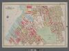
Plate 11: [Bounded by Noble St., Manhattan Ave., Calyer St., Diamond St., Norman Ave., Newell St., Driggs Ave., Graham Ave., Bayard St., Union Ave., Roebling Ave., N. Eleventh St., Driggs Ave., N. Ninth St., Bedford Ave., N. Seventh St., Berry St., N. Fi
from Atlas of the borough of Brooklyn, city of New York : from actual surveys and official plans by George W. and Walter S. Bromley.
[Plate 11: Bounded by Noble Street, Manhattan Avenue, Calyer Street, Diamond Street, Norman Avenue, Newell Street, Van Cott Avenue, Graham Avenue, Bayard Street, N. Eleventh Street,Driggs Street, N. Ninth Street, Bedford Avenue, N. Seventh Street, Berry
from Robinson's atlas of the city of Brooklyn, New York : embracing all territory within its corporate limits; from official records ... / by and under the supervision of E. Robinson and R.H. Pidgeon, civil engineers.
Double Page Plate No. 32: [Bounded by Marcy Ave., Metropolitan Ave., N. Fifth St., Havemeyer St., Withers St., Union Ave., Richardson St., Leonard St., Frost St., Manhattan Ave., Withers St., Graham Ave., Jackson St., Humboldt St., Metropolitan Ave., Bus
from Atlas of the Brooklyn borough of the City of New York : originally Kings Co.; complete in three volumes ... based upon official maps and plans ... / by and under the supervision of Hugo Ullitz, C.E.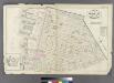
Plate 22: Bounded by N. 14th Street, Fifth Street, Union Avenue, N. 2nd Street, Third Street, N. 1st Street, River Street, N. 3rd Street and (East River) First Street.
from Atlas of the entire city of Brooklyn, complete in one volume. From actual surveys and official records by G. W. Bromley & Co.
Part of Wards 13 & 14. Land Map Section, No. 8, Volume 1, Brooklyn Borough, New York City.
from Atlas of the Brooklyn borough of the City of New York : originally Kings Co.; complete in three volumes ... based upon official maps and plans ... / by and under the supervision of Hugo Ullitz, C.E.
Double Page Plate No. 34: [Bounded by (New Town Creek) Commercial Street, Ash Street, Oakland Street, Paidge Avenue, Sutton Street, Meserole Avenue, Diamond Street, Calyer Street, Manhattan Avenue, Greenpoint Avenue, West Street and Bay Street.]
from Atlas of the Brooklyn borough of the City of New York : originally Kings Co.; complete in three volumes ... based upon official maps and plans ... / by and under the supervision of Hugo Ullitz, C.E.
Plate 14: Part of Wards 15, 17 & 18. Brooklyn, N.Y.
from Robinson's atlas of the city of Brooklyn, New York : embracing all territory within its corporate limits; from official records ... / by and under the supervision of E. Robinson and R.H. Pidgeon, civil engineers.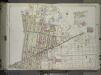
Brooklyn, Vol. 1, 2nd Part, Double Page Plate No. 35; Part of Wards 17 & 18, Section 9-10; [Map bounded by Calyer St., Newtown Creek, Richardson St. (Amos St.), Manhattan Ave., Meeker Ave.; Including Humboldt St., Nassau St., Jewel St., Meserole Ave.,...
From Volume 1, part 2
Part of Wards 17 & 18. Land Map Sections, No. 9 & 10, Volume 1, Brooklyn Borough, New York City.
from Atlas of the Brooklyn borough of the City of New York : originally Kings Co.; complete in three volumes ... based upon official maps and plans ... / by and under the supervision of Hugo Ullitz, C.E.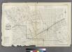
Plate 25: Part of Wards 15, 17, &18. City of Brooklyn.
from Atlas of the entire city of Brooklyn, complete in one volume. From actual surveys and official records by G. W. Bromley & Co.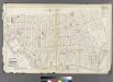
Plate 23: Bounded by Oakland Street, Meserole Street, Eckford Street, Norman Street, 15th Street, (East River) West Street, Commercial Street and Ash Street.
from Atlas of the entire city of Brooklyn, complete in one volume. From actual surveys and official records by G. W. Bromley & Co.
Plate 12: Bounded by Commercial Street (Newtown Creek), Ash Street, Paidge Avenue, Sutton Street, Calyer Street, Manhattan Avenue, Noble Street, West Street, Dupont Street and Franklin Street.
from Robinson's atlas of the city of Brooklyn, New York : embracing all territory within its corporate limits; from official records ... / by and under the supervision of E. Robinson and R.H. Pidgeon, civil engineers.
Plate 10: Bounded by N. Second Street, Kent Avenue, N. Third Street, Wythe Avenue, N. Fifth Street, Berry Street, N. Seventh Street, Bedford Avenue, N. Ninth Street, Driggs Street, N. 10th Street, Union Avenue, S. Second Street, Hooper Street, S. Third S
from Atlas of the city of Brooklyn, New York.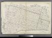
Plate 21: Part of Wards 13, 14, 15, 16 & 19 City of Brooklyn.
from Atlas of the entire city of Brooklyn, complete in one volume. From actual surveys and official records by G. W. Bromley & Co.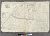
Plate 24: Part of Ward 17. City of Brooklyn.
from Atlas of the entire city of Brooklyn, complete in one volume. From actual surveys and official records by G. W. Bromley & Co.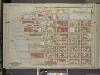
Brooklyn, Vol. 3, Double Page Plate No. 9; Part of Wards 14 & 17, Sections 8 & 9; [Map bounded by North Fourteenth St., Driggs Ave., North Fifth St., Including East River, Bushwick Greek]
from Wards 13, 14, 15, 16, 17, 18, 19, 27 & 28.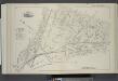
Vol. 6. Plate, C. [Map bound by Manhattan Ave., Leonard St., Van Cott Ave., North 14th St., Franklin St., Calyer St.; Including Lorimer St., Guernsey St., Dobbin St., Banker St., Gem St., West St., North 15th St., Quay St., Meserole Ave., Norman Ave., 2n
from Detailed estate and old farm line atlas of the city of Brooklyn : complete in six volumes ... from official records, private plans, and actual surveys ... / by G.M. Hopkins, C.E.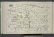
Vol. 6. Plate, K. [Map bound by Bushwick Inlet, N.14th St., Fifth St., N.6th St., East River; Including Banker St., N.13th St., N.12th St., N.11th St., N.10th St., N.9th St., N.8th St., N.7th St., First St., Second St., Third St., Fourth St.]
from Detailed estate and old farm line atlas of the city of Brooklyn : complete in six volumes ... from official records, private plans, and actual surveys ... / by G.M. Hopkins, C.E.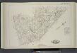
Vol. 6. Plate, J. [Map bound by Sixth St., N.6th St., Fifth St., Union Ave., Tenth St., Grand St.; Including Seventh St., Eighth St., Ninth St., Hope St., Ainslie St., N.2nd St., 5th St., N.7th St., N.8th St., N.9th St., N.10th St., N.11th St., N.12th St
from Detailed estate and old farm line atlas of the city of Brooklyn : complete in six volumes ... from official records, private plans, and actual surveys ... / by G.M. Hopkins, C.E.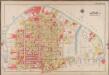
Plate 12: [Bounded by Commercial Street, Ash Street, Box Street, Paidge Avenue (Newtown Creek), Sutton Street, Calyer Street, Manhattan Avenue, Noble Street, West Street (East River Piers) and Commercial Street.]; Atlas of the borough of Brooklyn, city of New York: from actual surveys and official plans by George W. and Walter S. Bromley.
from Atlas of the borough of Brooklyn, city of New York : from actual surveys and official plans by George W. and Walter S. Bromley. G.W. Bromley & Co.,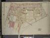
Brooklyn, Vol. 3, Double Page Plate No. 12; Part of Ward 17, Section 9; [Map bounded by Manhattan Ave., Bedford Ave., North Fourteenth St.; Including Bushwick Creek, East River, Greenpoint Ave.]
from Wards 13, 14, 15, 16, 17, 18, 19, 27 & 28.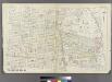
[Plate 27: Bounded by Withers Street, Kingsland Avenue, Parker Street, Vandervoort Avenue, Stagg Street, Morrill Street, Scholes Street and Union Avenue.]
from Atlas of the entire city of Brooklyn, complete in one volume. From actual surveys and official records by G. W. Bromley & Co.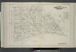
Vol. 6. Plate, O. [Map bound by Grand St., Eleventh St., S.2nd St., Union Ave., Broadway, Division Ave., Seventh St.; Including S.1St St., S.2nd St., S.3rd St., S.4th St., S.5th St., S.9th St., Seventh St., Eighth St., Ninth St., Tenth St., Eleventh St.,
from Detailed estate and old farm line atlas of the city of Brooklyn : complete in six volumes ... from official records, private plans, and actual surveys ... / by G.M. Hopkins, C.E.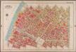
Plate 10: [Bounded by Metropolitan Ave., Kent Ave., N. Third St., Wythe Ave., N. Fifth St., Berry St., N. Seventh St., Bedford Ave., N. Ninth St., Driggs Ave., N. 10th St., Roebling St., Union Ave., S. Second St., Hooper St., S. Third St., Keap St., S. Fourth St., Rodney St., S. 5th St., Marcy Ave., Broadway, S. Roebling St., S. Ninth St., Bedford Ave., S. Tenth St., Berry St., S. 11th St., Kent Ave. & River St.]; Atlas of the borough of Brooklyn, city of New York: from actual surveys and official plans by George W. and Walter S. Bromley.
from Atlas of the borough of Brooklyn, city of New York : from actual surveys and official plans by George W. and Walter S. Bromley. G.W. Bromley & Co.,