Maps of Eastern
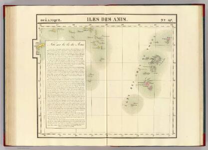
Iles des Amis. Oceanique no. 47.
1 : 1641836 Vandermaelen, Philippe, 1795-1869
Partie, Nle. Hollande. Oceanique no. 44.
1 : 1641836 Vandermaelen, Philippe, 1795-1869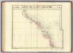
Partie, Nouv.- Hollande. Oceanique no. 45.
1 : 1641836 Vandermaelen, Philippe, 1795-1869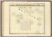
Partie, Iles Basses. Oceanique no. 48.
1 : 1641836 Vandermaelen, Philippe, 1795-1869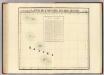
Partie, Iles Basses. Oceanique no. 49.
1 : 1641836 Vandermaelen, Philippe, 1795-1869
Partie du Perou. Amer. Merid. 25.
1 : 1641836 Vandermaelen, Philippe, 1795-1869
Partie, la Plata. Amer. Merid. 26.
1 : 1641836 Vandermaelen, Philippe, 1795-1869
Partie du Bresil. Amer. Merid. 27.
1 : 1641836 Vandermaelen, Philippe, 1795-1869
Partie du Bresil. Amer. Merid. 28.
1 : 1641836 Vandermaelen, Philippe, 1795-1869
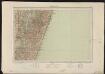
Cote Deserte. Afrique 48.
1 : 1641836 Vandermaelen, Philippe, 1795-1869
Mocaranga. Afrique 49.
1 : 1641836 Vandermaelen, Philippe, 1795-1869
Partie de Madagascar. Afrique 56.
1 : 1641836 Vandermaelen, Philippe, 1795-1869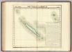
Nouvelle Caledonie. Oceanique no. 46.
1 : 1641836 Vandermaelen, Philippe, 1795-1869
Carte internationale du monde au 1,000,000 E
1 : 1000000 Windhoek (Namibie) Surveyor generals office S.W. Africa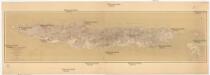
Nouvelle Calédonie
1 : 300000 Nová Kaledonie Laporte Challamel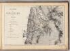
Mapa de la Republica de Chile (1)
1 : 11000000 Pissis, Aime, 1812-1889
Kennedy 2-mile map
1 : 130000 Survey Office, Dept. of Public Lands
Map of the principal Mining District of the Province of Minas Geraes in the Empire of Brazil
Map of the principal Mining District of the Province of Minas Geraes in the Empire of Brazil. Lithographed by J. Netherclift. [London]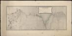
Plano topografico de la region norte argentina limitrofe con Bolivia
1 : 575000 (Argentine) Comision Argentina Demarcadora de Limites con Bolivia [Buenos Aires] :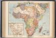
Afrika. Politische Ubersicht
1 : 20000000 Scobel, Albert
Copper mining district of Cloncurry, north western Queensland
1 : 380000 Ball, L. C. Geological Survey of Queensland
South America N.E. 45
1 : 7500000 Appleton, D. & Co.
Tananarive
1 : 500000 Madagascar. Service géographique [Tananarive] : Service géographique de Madagascar
Tananarive
1 : 500000 Madagascar. Service géographique [Tananarive] : Service géographique du Corps d'Occupation
Tananarive
1 : 500000 Madagascar. Service géographique [Tananarive] : Service géographique de Madagascar
A correct map of the African islands of Bourbon, and Mauritius or the Isle of France
1 : 887040
Ambositra
1 : 500000 Madagascar. Service géographique [Tananarive] : Service géographique de Madagascar
Ambositra
1 : 500000 Madagascar. Service géographique [Tananarive] : Service géographique de Madagascar
Ambositra
1 : 500000 Madagascar. Service géographique [Tananarive] : Service géographique de l'Etat Major du groupe de l'Afrique Orientale
Tamatave
1 : 500000 Madagascar. Service géographique [Tananarive] : Service géographique de Madagascar