Maps of Gloucester
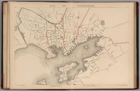
City of Gloucester, Massachusetts.
1 : 4800 Walker, O.W.
Gloucester
1 : 25000
Gloucester
1 : 24000
Gloucester
1 : 24000
Gloucester
1 : 24000
Gloucester
1 : 24000
Gloucester
1 : 31680
Gloucester
1 : 31680
Gloucester
1 : 31680
Lands of The Eastern Point Associates, East Gloucester, Mass
1 : 3550 Foss, William H Forbes Co.
Map of Gloucester, Cape Ann : shewing the roads, harbours, rivers, coves, islands & ledges surrounding that important cape, with directions for entering the harbours
1 : 25500 Mason, John Senefelder Lith. Co.
Map of Gloucester, Cape Ann : shewing the roads, harbours, rivers, coves, islands & ledges surrounding that important cape, with directions for entering the harbours
1 : 25500 Mason, John Senefelder Lithographic Co.
Gloucester
1 : 62500
Gloucester
1 : 62500
Gloucester
1 : 62500
Gloucester
1 : 62500
Gloucester
1 : 62500
Gloucester
1 : 62500
Gloucester
1 : 62500
Gloucester
1 : 62500
Gloucester
1 : 62500
43. Gloucester sheet.
1 : 62500 Massachusetts. Topographical Survey Commission
Gloucester
1 : 62500
Gloucester quadrangle, Massachusetts
1 : 62500 Geological Survey (U.S.) U.S. Geological Survey
Eldridge's new chart from Lynn to Halibut Point : with the harbors of Salem, Beverly, Marblehead, Manchester, Gloucester & Rockport, compiled from the latest surveys
1 : 58370 Eldridge, George, 1821-1879 S. Thaxter & Son
Cape Ann
1 : 125000
Essex & Norfolk counties.
1 : 158400 Gray, Ormando Willis; Walling, H. F.
The county of Essex : from actual survey
1 : 90000 Hales, John Groves [s.n.]
Gloucester
1 : 100000