Maps of North China Plain

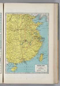
Eastern China.
1 : 6937000 Hammond, C.S.
China
1 : 6000000 Čína východní Kartogr. Anstalt Freytag & Berndt
China - East. Pergamon World Atlas.
1 : 5000000 Polish Army Topography Service
China.
1 : 13000000 Darton, William
Map of China and the surrounding regions
1 : 45000 Bretschneider, E., 1833-1901 A. Iliin
China.
1 : 10400000 Mitchell, Samuel Augustus
China.
1 : 10400000 Mitchell, Samuel Augustus
China.
1 : 5300000 Pinkerton, John, 1758-1826
Charte von China
1 : 6800000 nach Murdochischer Projection entworfen nach den neuesten und zuverlässigsten astronomischen Ortsbestimmungen berichtiget, und gezeichnet von H. F. A. Stieler, revidirt auf der Sternwarte Seeberg bey Gotha Weimar : Verlag des Geogr. Instituts
Die Küste und die Inseln des Chinesischen Reiches nach den neuesten englischen Quellen
1 : 7700000 Wien : H. F. Müller
China.
1 : 5702400 Stanford, Edward
China.
1 : 12800000 Lucas, Fielding Jr.
China.
1 : 6600000 Hall, S. (Sidney)
China.
1 : 6000000 John Bartholomew & Co.
Regni Sinae vel Sinae propriae mappa et descriptio geographica : ex mappis particularibus, quas Sinarum rex Canghi opera patrum missionariorum é S.I. in provincias regni universi ejus rei gratia ablegatorum concinnari fecit, perfecta, publicoque primum communicata in opere magnificentissimo R.P. du Halde, et ab Anvillaeo gall. reg. geographo in compendiosiorem hanc formam reducta, nunc secundum magis legitimas projectionis stereographicae leges reformata
1 : 5250000 Hase, Johann Matthias, 1684-1742 impensis Homanianorum Heredum
Regni Sinæ vel Sinæ propriæ mappa et descriptio geographica
1 Karte : Kupferdruck ; 57 x 51 cm Haas; Du Halde; Anville impensis Homanianorum Heredum
Regni Sinæ vel Sinæ propriæ mappa et descriptio geographica
1 Karte : Kupferdruck ; 57 x 51 cm Haas; Du Halde; Anville impensis Homanianorum Heredum
Die Küste und die Inseln des Chienischen Reiches
1 : 6500000 Čína Müller, H. F.
Di-gyiu Du, Ng Da-tsiu Di-du[地舆图、五大洲地图]
Di-gyiu Du, Ng Da-tsiu Di-du[地舆图、五大洲地图] 1853年,Martin, W. A. P. (William Alexander Parsons) 美国长老会传教士丁韪良用罗马拼音标注宁波方言编写的世界地理著作,对地球和各大洲进行介绍。内有东西半球图、亚洲图、欧洲图、非洲图、北美洲图、南美洲图、地中海附近图、清内地十八省图、浙江省图、宁波附近图等。 10图,墨刻本,罗马拼音标注宁波方言,图幅不一,约39 x 49.5 cm Harvard-Yenching | Rare Book | TA 2370 92,Hollis Number:008156153
REGNI SINAE vel SINAE PROPRIAE Mappa et Descriptio Geographica
1 : 5400000 Čína východní Hase, Johann Matthias Anville, Jean-Baptiste Bourguinon d' impensis Homan[n]ianorum Heredum
REGNI SINAE vel SINAE PROPRIAE Mappa et Descriptio Geographica
1 : 5400000 Čína východní Hase, Johann Matthias Anville, Jean-Baptiste Bourguinon d' impensis Homan[n]ianorum Heredum
Regni Sinae vel Sinae propriae mappa et descriptio geographica
1 : 5420000 Čína východní Hase, Johann Matthias Anville, Jean-Baptiste Bourguinon d' Homannianos Heredes
China. Coal Resources of the World.
1 : 6000000 McInnes, William; Leach, W.W.; Dowling, D.B.
99-100. Cina Propria, Corea.
1 : 5000000 Touring club italiano
China.
1 : 7700000 Society for the Diffusion of Useful Knowledge (Great Britain)
China-propria oder das eigentliche China
Čína Kiepert, Heinrich Kleinknecht
Pecheli, Xansi, Xantung, Honan, Nanking, In plaga Regni Sinensis inter Septentrionem ac Orientem Ceciam versus sitae Provinciae. [Karte], in: Novus atlas absolutissimus, Bd. 6, S. 127.
1 Karte aus Atlas Janssonius Offizin
117-118. China, Central and South. The World Atlas.
1 : 5000000 USSR (Union of Soviet Socialist Republics).
China, Flle. Sud.
1 : 5000000 Vivien St Martin, L.