Maps of Finland

68. Finlandia.
1 : 3000000 Touring club italiano
Suomen käsikarta
1 : 2000000 Finsko J.E. & S.G. Rosberg
Finnländische Zuwanderer in St. Petersburg - Paßanträge vom Jahre 1820 in % der Bevölkerung
Finnland, St. Petersburg, Migration
Geologische Übersichtskarte von Finland und den angrenzenden Landteilen
1 : 2500000 Sederholm, J.J. F. Tilgman
Suomi ja Itä-Karjala
1 : 2000000 Finsko Tilgmannin kivipaino
Distribution des dépôts quaternaires en Finlande
1 : 2000000 Sederholm, J.J. F. Tilgman
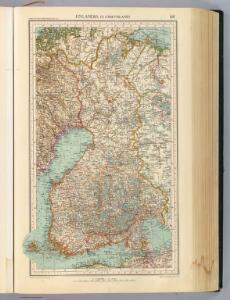
Suomi
1 : 2000000 Finsko Maanmittaushallituksen kivipaino
Suomi
1 : 2000000 Finsko Maanmittaushallituksen kivipaino
Prozentualer Anteil der Geldeinkünfte aus Saisonarbeit in St. Petersburg am Einkommen der Bauern in den 30er Jahren des 19. Jahrhunderts nach C.C. Böcker
Finnland Einkommen, Saisonarbeiter
Suomi
1 : 1000000 Finsko Maanmittaushallituksen kivipaino
La République de Finlande
1 : 2000000 Finsko F. Tilgmann
Spesielle kart 161c: Kommunekart over Norge med politi og lensmannsdistrikt
1 : 1000
Feuille 11 (D II), uit: Carte géologique internationale de l'Europe : la carte, votée au congrès géologique international de Bologne en 1881, est exécutée conformément aux décisions d'une commission internationale, avec le concours des gouvernements, sous le dir. de M.M. Beyrich et Hauchecorne
Annotatie: Blad 48 gamme des couleurs; blad 49: bladwijzer en titelblad Heinrich Ernst Beyrich 1815-1896; Wi. Hauchecorne Berlin : Reimer / (Berlin: Institut lithographique)
Spesielle kart 162b: Kommunekart over Norge, Med politi og lensmannsdistrikt, Med jurisdiksjonsinndeling
1 : 1000
52-53. Finland, Scandanavia, North. The World Atlas.
1 : 2500000 USSR (Union of Soviet Socialist Republics).

MAGNVS DVCATVS | FINLANDIÆ
Auct. Andrea Buræo Sueco. [Amsterdam : Joan Blaeu]
Magnus Ducatus Finlandiae Nova et accurata delineatio. [Karte], in: Novus atlas absolutissimus, Bd. 1, S. 48.
1 Karte aus Atlas Janssonius Offizin
Spesielle kart 42-2: Rigstelegraf- og Telefonkart over det nordlige Norge
1 : 800000
Das Grossfürstenthum Finland
1 : 2600000 Finsko Meissner, G. Benjamin Hermelin, S.G.
Trigonometrisk grunnlag, vedlegg 68d: Kart over de trigonometriske Hovednet
1 : 500000
(La Norwege, Islande)
1 : 14000000 Bruyset, Jean-Marie; Schneider, J. H.
Spesielle kart 164: Dagligvarehandel i Norge.
1 : 1000
Spesielle kart 161b: Kommunekart over Norge med politi og lensmannsdistrikt
1 : 1000
Spesielle kart 64: Norvège Carte Zoo-Géographique, blad 3
1 : 2400000 Robert Collett
Spesielle kart 63: Pflanzengeographische Karte Über Das Königreich Norwegen, blad 2
1 : 1000000 F. C. Schübeler
Voenno-dorožnaja karta časti Rossii i pograničnych zemelʹ
1 : 1680000 Schweden, Finnland Šubert [Generalmajor]
Spesielle kart 7: Postkart over det nordlige Norge
1 : 1600000
Karta Finljandīi s pokazanīem granic Rosīi i Švecīi po raznym dogovorom
1 : 600000 Finnland Nordischer Krieg <1700-1721>