Maps of Asia

(World, gnomonic proj. V. North Pole-45 N. Lat.)
1 : 5000000 Society for the Diffusion of Useful Knowledge (Great Britain)
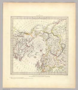
Frontispiece: North Pole Chart.
1 : 23500000 Johnston, Alexander Keith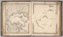
Northern Regions, North Pole. Southern Regions, South Pole.
Colton, G.W.
River Ice in Relation to Navigation, Closing Dates.
U.S. Navy
Ice Chart, Northern Hemisphere, December.
U.S. Navy
Ice Chart, Northern Hemisphere, July.
U.S. Navy
Ice Chart, Northern Hemisphere, November.
U.S. Navy
248-249. Arctic, Antarctic. The World Atlas.
1 : 20000000 USSR (Union of Soviet Socialist Republics).
Regions Polaires
Vivien St Martin, L.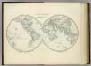
World in Hemispheres.
1 : 72000000 Johnston, Alexander Keith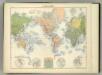
Planisphere.
1 : 82000000 Jouvet et Cie.
The World.
1 : 110000000 Hughes, William
Mappe -Monde en deux Hemispheres.
1 : 95000000 Vivien de St Martin, L.
Forest Trees, Useful Plants, and Minerals.
1 : 100000000 Johnson, A.J.
World on Mercator's Projection.
1 : 65000000 Asher & Adams
Amerique Boreale, Nlle. Bretagne, Canada.
1 : 15000000 Garnier, F. A., 1803-1863
A general map of North America: drawn from the best surveys / by J. Russell; J. Russell, sculpt, Constitution Row, Grey's Inn Lane.
from Charts and maps J. Russell,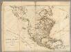
North America, As Divided amongst the European Powers.
1 : 16500000 Robert Sayer and John Bennett (Firm)
Map Of North America.
1 : 28000000 Mitchell, Samuel Augustus
North America.
1 : 33000000 Cornell, S. S. (Sarah S.)
Northern Regions.
1 : 22176000 Colton, G.W.
The Arctic regions
1 : 14673400 Arktida National Geographic Society
North Polar Regions.
1 : 22000000 Rand McNally and Company
A new map of North America: with the British, French, Spanish, Dutch & Danish dominions on that great continent, and the West India Islands, according to the definitive treaty concluded at Paris 10th February 1763 / with great improvements from the Sieurs d'Anville & Robert.
from Charts and maps Printed for Robt. Sayer, map and printseller at the Golden Bunk in Fleet Street: London; Robert de Vaugondy, Didier; Anville, Jean Baptiste Bourguignon d',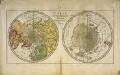
Carte des deux regions polaires
2 Karten auf einem Blatt : Kupferdruck ; Durchmesser je 20 cm Lange; Berndt s.n.
Polar-Karte enthaltend: die Lander u. Meere vom Nord-Pol bis 50 degrees N.
1 : 29000000 Stieler, Adolf
3. Terre polari.
1 : 45000000 Touring club italiano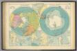
Polar Regions.
1 : 35000000 Philip, George
Ice Chart, Northern Hemisphere, April.
U.S. Navy