Maps of Lombardia

Sheet XI: Karte Des Oesterreichischen Kaiserstaates.
1 : 576000 Scheda, Josef
XI, uit: General-Karte des oesterreichischen Kaiserstaates mit einem grossen Theile der angrenzenden Länder / durch Josef Scheda ... bearb. und hrsg
1 : 576000 Annotatie geografische gegevens: Maatstokken: oesterreichische Meilen, geografische oder deutsche Meilen, preussische Meilen, türkische Berri, französische Lieues, russische Werste; Maatstok per blad: wiener Klafter, öster. Meilen; Blad XIX: statistische en taalkundige informatie; Blad XIX: legenda [Wien : K.K. Militärisch-Geografisches Institut]
E.7. Mailand, uit: [Übersichtskarte von Europa 1:750.000]
1 : 750000 Wien : K.u.K. Militärgeographisches Institut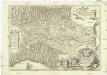
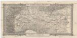
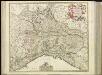
Statto di Milano e prouincie confinanti dalla parte orientale &
1 : 755000 Itálie severní Frattino, Giulio Carlo Surello, D.
De Stoel des Oorlogs in Italien
1 : 750000 Mollova mapová sbírka Visscher, Nicolaes Anse, Luggert van Schenk, Peter II
Longobardia Divisa in status suos
1 : 900000 Mollova mapová sbírka Wolf, Jeremias Wolff, Jeremias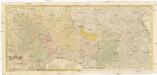
Cursus fluminis Padi vel Po per Longobardiam a fonte usque ad Ostia
1 : 493000 Lombardie (Itálie) Cerruti, Augusto ab Homannianis Heredibus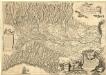
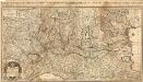
Stato di Milano e Prouincie Consinanti dalla Parte Orientale &c.
1 : 740000 Mollova mapová sbírka Frattino, Giulio Carlo Durello, Simone
Übersichtskarte von Mittel - Europa


Übersichtskarte von Mittel - Europa

Belli typvs in Italia, victris Aquilae progreßus in statv Mediolanesi et dvcatv Mantvae demonstrans
1 : 530000 Itálie severní Homann, Johann Baptist per Io. Bapt. Homannvm
Ducatus Mediolanensis cum adjacentibus Principat. Et Dominiis

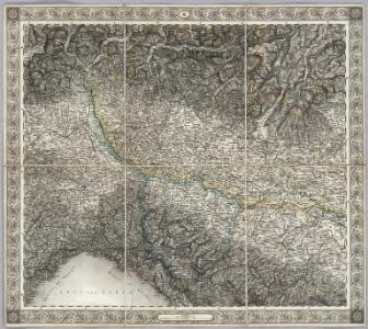
Mailand, Genua, Bologna, Florenz
1 : 750000 Bologna (Itálie) Klatecki, L. von K. u. k. Militärgeographisches Institut
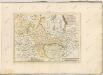
Mailand, Genua, Bologna, Florenz
1 : 750000 Bologna (Itálie) K. k. militär-geographisches Institut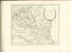

Carte Nouvelle du Milanez
1 : 530000 Mollova mapová sbírka Baillieul, Gaspard Desbruslins, F. Bailleul, Gaspard
Ducatus Mediolanensis cum adjacentibus principat. et dominiis accuratissime delineatus
1 : 536000 Itálie severní Seutter, Matthäus sumptibus Matthaei Seuteri
Schema k ital'janskomu pochodu.
Italien Koalitionskrieg <1798-1802> Suvorov, Aleksandr V.
[29][29] Reipublicae Genuensis et Ducatus Mediolanensis ..., uit: Atlas sive Descriptio terrarum orbis
Annotatie: Gedigitaliseerde versie. Amsterdam. Heiloo : Picturae (vervaardiger), 2015. tiff-bestand. Gedigitaliseerd: 07-01-2015; Origineel: Universiteitsbibliotheek Vrije Universiteit (XL.05127.-) ; Netherlands; Titelpagina ontbreekt Wit, Frederik de Amsterdam : Frederick de Wit
Status Mediolanensis nec non Ducatum Mantuae, Modenae, Parmae ut et Genuensis Reipublicae
1 : 720000 Mollova mapová sbírka Valk, Gerhard Overton, John
Seconde Carte du Téatre de la Guerre en Italie
1 : 430000 Mollova mapová sbírka Mortier, Pieter Mortier, Pierre
Ducatus Mediolanensis Placentini et Parmensis nova tabula
1 Karte : Kupferdruck ; 32 x 38 cm Weigel; Kauffer Christoph Weigel
Ducatus Medioliani
1 : 523000 Lombardie (Itálie) Homann, Johann Baptist per Ioh. Bapt. Homannum
Sedes Belli in Italia; in quâ sunt Ducatus Mantuensis, Modenensis
1 : 650000 Mollova mapová sbírka Ottens, Reinier Ottens, Josua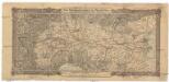
Der Kriegsschauplatz in Ober-Italien
1 : 860000 Itálie severní Pauliny Rudolf Lechner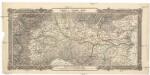
Bojiště v hořejší Itálii
1 : 870000 Itálie severní Pauliny Rudolf Lechner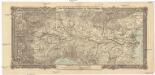
Der Kriegsschauplatz in Ober-Italien
1 : 860000 Itálie severní Pauliny Rudolf Lechner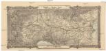
Bojiště v hořejší Itálii
1 : 870000 Itálie severní Pauliny Rudolf Lechner