Maps of Golden's Bridge
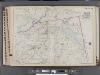
Westchester, V. 2, Double Page Plate No. 41 [Map bounded by Part of the towns of Somers, Lewisboro, Bedford]
From Vol. 2
11. Mt. Kisco-Yorktown-Cross River.
1 : 80000 Servoss, R. D.
Town of Bedford, Westchester County, New York.
1 : 38169 Beers, J.B.
Bedford,Town.
1 : 38016 Beers, F. W. (Frederick W.)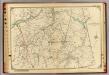
13 Atlas rural country district north of New York City.
1 : 18000 Hyde, E. Belcher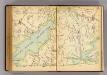
262-263 Bedford.
1 : 21600 G.W. Bromley & Co.
Villages West Chester Co.
Bromley, George Washington; Bromley, Walter Scott; G.W. Bromley & Co.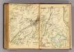
268-269 Bedford, Somers.
1 : 21600 G.W. Bromley & Co.
Somers, Town.
1 : 25344 Beers, F. W. (Frederick W.)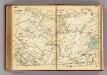
244-245 Bedford.
1 : 21600 G.W. Bromley & Co.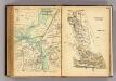
264-265 Bedford, Lewisboro, Somers, Katonah.
1 : 21600 G.W. Bromley & Co.
Katanoh, Town of Bedford, N.Y. - Mount Kisco, Town of Bedford and New Castle, Westchester Co. N.Y.
from County atlas of Westchester, New York. Published by J.B. Beers & Co., assisted by S.W. Wilson and others.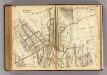
250-251 Mt. Kisco.
1 : 7200 G.W. Bromley & Co.
Bedford, Somers towns.
1 : 31680 Bien, Joseph Rudolf
Plate 75: Town of Somers, Westchester Co. N.Y.
from County atlas of Westchester, New York. Published by J.B. Beers & Co., assisted by S.W. Wilson and others.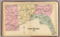
Part of West Chester Co.
1 : 14400 Bromley, George Washington; Bromley, Walter Scott; G.W. Bromley & Co.
Plate 76: Town of Bedford, Westchester Co. N.Y.
from County atlas of Westchester, New York. Published by J.B. Beers & Co., assisted by S.W. Wilson and others.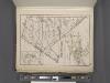
Westchester, Plate No. 29 [Map of Town of New Castle, Village of Mt.Kisco, Village of Chappaqua] / prepared under the direction of Joseph R. Bien, from general surveys and official records.
From Atlas of Westchester County, New York
11. Mt. Kisco-Yorktown-Cross River.
1 : 80000 Servoss, R. D.
Plate 80: Town of North Salem, Westchester Co. N.Y.
from County atlas of Westchester, New York. Published by J.B. Beers & Co., assisted by S.W. Wilson and others.
Town of Lewisboro, Westchester County, New York. (insets) Goldens Bridge. Cross River. South Salem.
1 : 47639 Beers, Frederick W.
Lewisboro, Town.
1 : 48738 Beers, F. W. (Frederick W.)
Croton Lake vicinity.
1 : 31680 Vermeule, C. C. (Cornelius Clarkson), 1858-1950
Town of Somers, Westchester County, New York. (Inset) Somers.
1 : 31680 Beers, Frederick W.
Poundridge, Lewisboro, N. Salem towns.
1 : 31680 Bien, Joseph Rudolf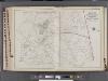
Westchester, V. 2, Double Page Plate No. 40 [Map bounded by Part of the Towns of Poundridge, Bedford, North Castle]
From Vol. 2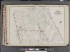
Westchester, V. 2, Double Page Plate No. 44 [Map bounded by State of Connecticut, Poundridge, Bedford]
From Vol. 2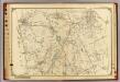
14 Atlas rural country district north of New York City.
1 : 18000 Hyde, E. Belcher
Croton Falls
1 : 24000
Croton Falls
1 : 24000
Croton Falls
1 : 24000
Croton Falls
1 : 24000
Croton Falls
1 : 31680
![Westchester, V. 2, Double Page Plate No. 41 [Map bounded by Part of the towns of Somers, Lewisboro, Bedford]](https://images-2.georeferencer.com/images/iiif/072472391893/full/,300/0/native.jpg)

