Maps of Greenville
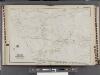
Westchester, V. 2, Double Page Plate No. 14 [Map bounded by New Sprain Rd., Scarsdale, City of Yonkers]
From Vol. 2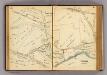
60-61 Yonkers.
1 : 7200 G.W. Bromley & Co.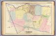
24. Yonkers.
1 : 3600 Kiser, Ellis; Mueller, A. H.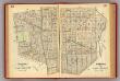
66-67 Scarsdale, East Chester.
1 : 5400 G.W. Bromley & Co.
60-61 Scarsdale.
1 : 5400 G.W. Bromley & Co.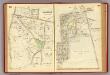
62-63 Scarsdale.
1 : 5400 G.W. Bromley & Co.
64-65 Scarsdale, East Chester.
1 : 5400 G.W. Bromley & Co.
Westchester, Double Page Plate No. 21 [Map of village of Hastings, Village of Dobbs Ferry, Village of Irvington] / prepared under the direction of Joseph R. Bien, from general surveys and official records.
From Atlas of Westchester County, New York
15. Yonkers.
1 : 3600 Kiser, Ellis; Mueller, A. H.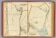
68-69 Eastchester.
1 : 9600 G.W. Bromley & Co.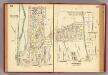
56-57 Scarsdale.
1 : 5400 G.W. Bromley & Co.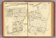
54-55 Scarsdale.
1 : 5400 G.W. Bromley & Co.
Town of Greenburgh, Westchester County, New York.
1 : 42240 Beers, Frederick W.
Plates 53 & 54: Town of New Rochelle, Westchester Co. N.Y. - Town of Pelham, Westchester Co. N.Y. - City Island, Pelham Township, Westchester Co. N.Y.
from County atlas of Westchester, New York. Published by J.B. Beers & Co., assisted by S.W. Wilson and others.
Plate 68: Town of White Plains, Westchester Co. N.Y. - Town of Scarsdale, Westchester Co. N.Y.
from County atlas of Westchester, New York. Published by J.B. Beers & Co., assisted by S.W. Wilson and others.
Small folder - S1
from Atlas of New York and vicinity : from actual surveys / by and under the direction of F. W. Beers, assisted by A. B. Prindle & others
Map of upper New York City and adjacent country showing the city above 125th Street. The City of Yonkers and Townships of East Chester, Westchester, Pelham, New Rochelle. . . Mamaroneck. Made by actual surveys under the direction of R. W. Burrowes, C....
From Bronx
4. Yonkers-Tarrytown-Hartsdale.
1 : 80000 Servoss, R. D.
Plate 30: Town of Greenburgh, Westchester Co. N.Y.
from Atlas of New York and vicinity : from actual surveys / by and under the direction of F. W. Beers, assisted by A. B. Prindle & others
Westchester, Double Page Plate No. 4 [Map of Towns of Yonkers, Mt. Vernon, Eastchester] / prepared under the direction of Joseph R. Bien, from general surveys and official records.
From Atlas of Westchester County, New York
Westchester, Double Page Plate No. 20 [Map of town of Greenburg] / prepared under the direction of Joseph R. Bien, from general surveys and official records.
From Atlas of Westchester County, New York
Map of Westchester Co.
1 : 45000 G.W. Bromley & Co.
Plates 21 & 22: Town and City of Yonkers, Westchester Co. N.Y. - Town of East Chester, Westchester Co. N.Y.
from County atlas of Westchester, New York. Published by J.B. Beers & Co., assisted by S.W. Wilson and others.
Greenburgh, Westchester County, New York.
1 : 42240 Beers, Frederick W.
5 Greenburg.
1 : 18000 Hyde & Company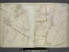
Portion of Rockland County. ; Portion of Westchester County.
from Atlas of the Hudson River Valley from New York city to Troy, including a section of about 8 miles in width. Published by Watson & co. Compiled from official records and careful surveys, under the supervision of F. W. Beers.
Plates 21 & 22: Town and City of Yonkers, Westchester Co. N.Y. - Town of East Chester, Westchester Co. N.Y.
From County atlas of Westchester, New York. Published by J.B. Beers & Co., assisted by S.W. Wilson and others.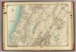
3 Atlas rural country district north of New York City.
1 : 13000 Hyde, E. Belcher
Town of Greenburgh, Westchester County, New York.
1 : 42240 Beers, Frederick W.
Westchester Co., Yonkers-state line.
1 : 31680 Bien, Joseph Rudolf; Vermeule, C. C. (Cornelius Clarkson), 1858-1950
![Westchester, V. 2, Double Page Plate No. 14 [Map bounded by New Sprain Rd., Scarsdale, City of Yonkers]](https://images-2.georeferencer.com/images/iiif/779280084740/full/,300/0/native.jpg)

