Maps of Smithtown
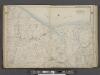
Suffolk County, V. 2, Double Page Plate No. 3 [Map bounded by Long Island Sound, Smith Town Bay, St. James, Smith Town, Com Mack, Kings Park] / supplemented by careful measurements & field observations by our own Corps of Engineers.
From Vol. 2, North
Saint James
1 : 24000
Saint James
1 : 24000
Saint James
1 : 24000
St James
1 : 24000
St James
1 : 24000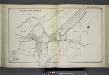
Smith Town Branch
from Atlas of ... Suffolk County, Long Island, New York ... : based upon actual measurements by our own corps of engineers, maps on file at county offices, also maps from actual surveys furnished by individual owners / under the supervision of Merritt B. Hyde.
Stony Brook
from Atlas of ... Suffolk County, Long Island, New York ... : based upon actual measurements by our own corps of engineers, maps on file at county offices, also maps from actual surveys furnished by individual owners / under the supervision of Merritt B. Hyde.
Suffolk County, V. 2, Double Page Plate No. 16 [Map bounded by Center Port, East North Port, Fair Ground] / supplemented by careful measurements & field observations by our own Corps of Engineers.
From Vol. 2, North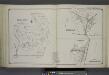
Belle Crest; Melville; Commack
from Atlas of ... Suffolk County, Long Island, New York ... : based upon actual measurements by our own corps of engineers, maps on file at county offices, also maps from actual surveys furnished by individual owners / under the supervision of Merritt B. Hyde.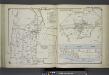
East Northport; Greenlawn; Asharoken Beach
from Atlas of ... Suffolk County, Long Island, New York ... : based upon actual measurements by our own corps of engineers, maps on file at county offices, also maps from actual surveys furnished by individual owners / under the supervision of Merritt B. Hyde.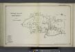
Vernon Valley and Part of Northport
from Atlas of ... Suffolk County, Long Island, New York ... : based upon actual measurements by our own corps of engineers, maps on file at county offices, also maps from actual surveys furnished by individual owners / under the supervision of Merritt B. Hyde.
Setauket
from Atlas of ... Suffolk County, Long Island, New York ... : based upon actual measurements by our own corps of engineers, maps on file at county offices, also maps from actual surveys furnished by individual owners / under the supervision of Merritt B. Hyde.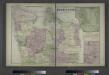
Vernon Valley, Town of Huntington, Suffolk Co.
from Atlas of Long Island, New York. From recent and actual surveys and records.
Setauket
1 : 62500
Setauket
1 : 62500
Setauket
1 : 62500
Setauket
1 : 62500
Setauket
1 : 62500
Setauket
1 : 62500
Setauket
1 : 62500
Setauket
1 : 62500
Setauket
1 : 62500
Northport
1 : 24000
Northport
1 : 24000
Northport
1 : 24000
Northport
1 : 24000
Northport
1 : 24000
Central Islip
1 : 24000
Central Islip
1 : 24000
Central Islip
1 : 24000
Central Islip
1 : 24000
Central Islip
1 : 24000
![Suffolk County, V. 2, Double Page Plate No. 3 [Map bounded by Long Island Sound, Smith Town Bay, St. James, Smith Town, Com Mack, Kings Park] / supplemented by careful measurements & field observations by our own Corps of Engineers.](https://images-2.georeferencer.com/images/iiif/646624509705/full/,300/0/native.jpg)

