Maps of Queens County

Manhattan, V. 7, Plate No. 67 [Map bounded by Hudson River, Marginal St.]
From Atlas 120. Vol. 7, 1902.
Manhattan, V. 7, Plate No. 68 [Map bounded by Hudson River, Riverside Park]
From Atlas 120. Vol. 7, 1902.
Manhattan, V. 7, Plate No. 1 [Map bounded by Hudson River, W. 76th St., W. End Ave., W. 72nd St.]
From Atlas 120. Vol. 7, 1902.
Manhattan, V. 7, Plate No. 5 [Map bounded by NY central and Hudson Railroad, W. 81st St., W. End Ave., W. 76th St.]
From Atlas 120. Vol. 7, 1902.
Riverside Park [New York City.]
From Manhattan
[Plate 26: Bounded by W. 86th Street, Central Park West (8th Avenue), W. 75th Street and Hudson River.]
from Atlas of the city of New York, Manhattan Island. From actual surveys and official plans / by George W. and Walter S. Bromley.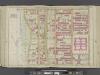
Manhattan, Double Page Plate No. 26 [Map bounded by W. 86th St., Central Park W., W. 75th St., Hudson River]
From Atlas of the city of New York, Manhattan Island. From actual surveys and official plans
Part of Section 4 : New York City.
from Atlas of the city of New York, borough of Manhattan. From actual surveys and official plans / by George W. and Walter S. Bromley.
[Plate 92: Bounded by W. 83rd Street, Amsterdam Avenue, W. 77th Street, and [Hudson River, Riverside Park] Riverside Drive.]
from Atlas of the borough of Manhattan, city of New York.
Part of Section 4 : Plate 90.
from Atlas of the borough of Manhattan, city of New York.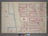
Plate 6, Part of Section 4: [Bounded by W. 77th Street, Amsterdam Avenue, W. 71st Street, West End Avenue, W. 72nd Street and Riverside Drive.]
from Atlas of the city of New York, borough of Manhattan. From actual surveys and official plans / by George W. and Walter S. Bromley.
Plate 7, Part of Section 4: [Bounded by W. 83rd Street, Amsterdam Avenue, W. 77th Street and (Riverside Park) Riverside Drive.]
from Atlas of the city of New York, borough of Manhattan. From actual surveys and official plans / by George W. and Walter S. Bromley.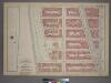
Plate 6, Part of Section 4: [Bounded by W. 77th Street, Amsterdam Avenue, W. 71st Street and (Riverside Park) Riverside Drive.]
from Atlas of the city of New York, borough of Manhattan. From actual surveys and official plans / by George W. and Walter S. Bromley.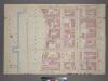
Plate 7, Part of Section 4: [Bounded by W. 83rd Street, Amsterdam Avenue, W. 77th Street, West End Avenue and Riverside Drive.]
from Atlas of the city of New York, borough of Manhattan. From actual surveys and official plans / by George W. and Walter S. Bromley.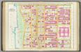
Pl. 26: ward 22.
1 : 1800 Bromley, George Washington; Bromley, Walter Scott
Part of Section 4 : Plate 88.
from Atlas of the borough of Manhattan, city of New York.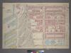
Plate 3, Part of Section 4: [Bounded by W. 71st Street,Amsterdam Avenue, W. 65th Street and (NewYork Central & Hudson River Rail Road Co.) West End Avenue.]
from Atlas of the city of New York, borough of Manhattan. From actual surveys and official plans / by George W. and Walter S. Bromley.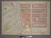
Plate 3, Part of Section 4: [Bounded by W. 71st Street, Amsterdam Avenue, W. 65th Street and (Hudson River Piers) West End Avenue.]
from Atlas of the city of New York, borough of Manhattan. From actual surveys and official plans / by George W. and Walter S. Bromley.
Manhattan, V. 6, Double Page Plate No. 115 [Map bounded by W. 72nd St., Amsterdam Ave., W. 67th St., 12th Ave.]
From Atlas 117. Vol. 6, 1892.
Manhattan, V. 7, Plate No. 9 [Map bounded by W. 86th St., W. End Ave., W. 81st St., Hudson River]
From Atlas 120. Vol. 7, 1902.
Manhattan, V. 7, Plate No. 2 [Map bounded by W. 76th St., Amsterdam Ave., W. 72nd St., W. End Ave.]
From Atlas 120. Vol. 7, 1902.
Manhattan, V. 7, Plate No. 69 [Map bounded by Hudson River, Riverside Park]
From Atlas 120. Vol. 7, 1902.
Manhattan, V. 7, Plate No. 6 [Map bounded by W. 81st St., Amsterdam Ave., W. 76th St., W. End Ave.]
From Atlas 120. Vol. 7, 1902.
Sheet 13: [Bounded by W. Ninty First Street, (New Reservoir) 5th Avenue, Fifty Ninth Street and 12th Avenue.]
from Plan of New York City, from the Battery to Spuyten Duyvil Creek. Showing every lot and building thereon; old farm lines, strreet numbers at the corners of blocks, railroads, steamboat landings, bulkhead and pier lines, etc. Based on the surveys made by Messrs. Randall & Blackwell, and on the special survey by J. F. Harrison.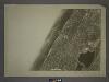
5D - N.Y. City (Aerial Set).
from Sectional aerial maps of the City of New York / [photographed and assembled under the direction of the chief engineer, July 1st, 1924].
Sackersdorff Farm set.
from Sackersdorf Farm Set.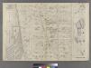
Part of Ward 22, New York City.
from Atlas of the city of New York : embracing all territory within its corporate limits from official records, private plans & actual surveys / by and under the supervision of E. Robinson & R.H. Pidgeon, civil engineers.
Sackersdorff Farm Set.
from Maps of farms commonly called the Blue book, 1815 : drawn from the original on file in the street commissioner's office in the City of New York, together with lines of streets and avenues / laid out by John Randel, jr., 1819-20.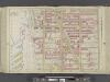
Manhattan, Double Page Plate No. 25 [Map bounded by W. 75th St., Central Park W., W. 64th St., Hudson River]
From Atlas of the city of New York, Manhattan Island. From actual surveys and official plans
![Manhattan, V. 7, Plate No. 67 [Map bounded by Hudson River, Marginal St.]](https://images-3.georeferencer.com/images/iiif/435091669592/full/,300/0/native.jpg)

