Maps of Queens County
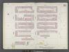
Manhattan, V. 6, Double Page Plate No. 121 [Map bounded by E. 72nd St., 1st Ave., E. 67th St., 3rd Ave.]
From Atlas 117. Vol. 6, 1892.
Plate 121: Map bounded by East 72nd Street, First Avenue, East 67th Street, Third Avenue
from Maps of the city of New York.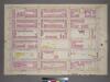
Plate 22, Part of Section 5: [Bounded by E. 71st Street, Avenue A, E. 65th Street and Third Avenue.]
from Atlas of the city of New York, borough of Manhattan. From actual surveys and official plans / by George W. and Walter S. Bromley.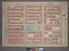
Plate 22, Part of Section 5: [Bounded by E. 71st Street, Avenue A, E. 65th Street and Third Avenue.]
from Atlas of the city of New York, borough of Manhattan. From actual surveys and official plans / by George W. and Walter S. Bromley.
[Plate 107: Bounded by E. 71st Street, Avenue A, E. 65th Street and Third Avenue.]
from Atlas of the borough of Manhattan, city of New York.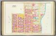
Pl. 27: ward 19.
1 : 1800 Bromley, George Washington; Bromley, Walter Scott
Part of Section 5: Plate 111.
from Atlas of the borough of Manhattan, city of New York.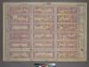
Plate 25, Part of Section 5: [Bounded by E. 77th Street, Avenue A, E. 71st Street and Third Avenue.]
from Atlas of the city of New York, borough of Manhattan. From actual surveys and official plans / by George W. and Walter S. Bromley.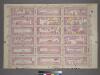
Plate 25, Part of Section 5: [Bounded by E. 77th Street, Avenue A, E.71st Street and Third Avenue.]
from Atlas of the city of New York, borough of Manhattan. From actual surveys and official plans / by George W. and Walter S. Bromley.
Part of Section 5: Plate 106.
from Atlas of the borough of Manhattan, city of New York.
Part of Section 5: Plate 109.
from Atlas of the borough of Manhattan, city of New York.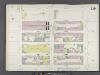
Manhattan, V. 6, Double Page Plate No. 119 [Map bounded by E. 67th St., 1st Ave., E. 62nd St., 3rd Ave.]
From Atlas 117. Vol. 6, 1892.
Plate 120: Map bounded by East 72nd Street, East River, East 63rd Street, First Avenue
from Maps of the city of New York.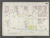
Manhattan, V. 6, Double Page Plate No. 120 [Map bounded by 1st Ave., E. 72nd St., East River, E. 63rd St.]
From Atlas 117. Vol. 6, 1892.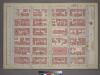
Plate 23, Part of Section 5: [Bounded by E. 71st Street, Third Avenue, E. 65th Street and (Central Park) Fifth Avenue.]
from Atlas of the city of New York, borough of Manhattan. From actual surveys and official plans / by George W. and Walter S. Bromley.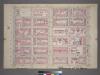
Plate 23, Part of Section 5: [Bounded by E. 71st Street, Third Avenue, E. 65th Street and Fifth Avenue.]
from Atlas of the city of New York, borough of Manhattan. From actual surveys and official plans / by George W. and Walter S. Bromley.
Plate 119: Map bounded by East 67th Street, First Avenue, East 62nd Street, Third Avenue
from Maps of the city of New York.
Manhattan, V. 6, Double Page Plate No. 122 [Map bounded by E. 72nd St., 5th Ave., E. 67th St., 3rd Ave.]
From Atlas 117. Vol. 6, 1892.
Manhattan, V. 8, Double Page Plate No. 154 [Map bounded by 3rd Ave., E. 79th St., 1st Ave., E. 72nd St.]
From Atlas 122. Vol. 8, 1896.
Plate 122: Map bounded by East 72nd Street, Third Avenue, East 67th Street, Fifth Avenue
from Maps of the city of New York.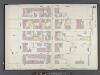
Manhattan, V. 8, Double Page Plate No. 153 [Map bounded by E. 77th St., East River, E. 72nd St., 1st Ave.]
From Atlas 122. Vol. 8, 1896.
[Plate 28: Bounded by Fifth Avenue, E. 80th Street, Second Avenue, and E. 84th Street.]
from Atlas of the city of New York, Manhattan Island. From actual surveys and official plans / by George W. and Walter S. Bromley.
[Plate 28: Bounded by Fifth Avenue, E. 80th Street, Second Avenue, and E. 64th Street.]
from Atlas of the city of New York, borough of Manhattan. From actual surveys and official plans / by George W. and Walter S. Bromley.
Pl. 28: ward 19.
1 : 1800 Bromley, George Washington; Bromley, Walter Scott
20. Ward 19.
1 : 2400 G.W. Bromley & Co.; Geo. W. Bromley & E. Robinson
Manhattan, Double Page Plate No. 28 [Map bounded by 5th Ave., E. 80th St., 2nd Ave., E. 64th St.]
From Atlas of the city of New York, Manhattan Island. From actual surveys and official plans
Plate 19: Bounded by E. 76th Street, East River (Avenue A), E. 64th Street, and Fifth Avenue.
from Atlas of the city of New York : embracing all territory within its corporate limits from official records, private plans & actual surveys / by and under the supervision of E. Robinson & R.H. Pidgeon, civil engineers.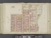
Manhattan, Double Page Plate No. 27 [Map bounded by E. 68th St., East River, E. 57th St., Lexington Ave.]
From Atlas of the city of New York, Manhattan Island. From actual surveys and official plans
Sackersdorff Farm Set.
from Maps of farms commonly called the Blue book, 1815 : drawn from the original on file in the street commissioner's office in the City of New York, together with lines of streets and avenues / laid out by John Randel, jr., 1819-20.
![Manhattan, V. 6, Double Page Plate No. 121 [Map bounded by E. 72nd St., 1st Ave., E. 67th St., 3rd Ave.]](https://images-1.georeferencer.com/images/iiif/530333675202/full/,300/0/native.jpg)

