Maps of Kings County

Brooklyn V. 11, 1918 of New Sheet Map No. 34 [Map bounded by 59th St., 2nd Ave., 63rd St., 1st Ave.]
From Atlas 95. Vol. 11, 1905.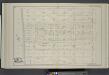
Vol. 4. Plate, P. [Map bound by Fifty-Second, Fourth Ave., City Line, Gowanus Bay; Including Fifty-Third St., Fifty-Fourth St., Fifty-Fifth St., Fifty-Sixth St., Fifty-Seventh St., Fifty-Eighth St., Fifty-Ninth St., First Ave., Second Ave., Third Ave.]
from Detailed estate and old farm line atlas of the city of Brooklyn : complete in six volumes ... from official records, private plans, and actual surveys ... / by G.M. Hopkins, C.E.
Brooklyn, Vol. 6, Double Page Plate No. 12; Part of Ward 30, Section 18; [Map bounded by 2nd Ave., Ridge Blvd., 68th St.; Including Shore Road, 60th St.]
from Ward 30.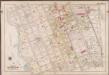
Plate 2: [Bounded by Mackay Pl., 1st Ave., 72nd St., 2nd Ave., 73rd St., 3rd Ave., 74th St., 4th Ave., 75th St., 6th Ave., 78th St., 5th Ave., 89th St., 3rd Ave., 88th St., 2nd Ave., 87th St., 1st Ave., 86th St. & Bayridge Pkwy.]; Atlas of the borough of Brooklyn, city of New York: from actual surveys and official plans by George W. and Walter S. Bromley.
from Atlas of the borough of Brooklyn, city of New York : from actual surveys and official plans by George W. and Walter S. Bromley. G.W. Bromley & Co.,
Plate 1: [Bounded by 60th St., Seventh Ave., 67th St., Stewart Ave., 72nd St., Sixth Ave., 75th St., Fourth Ave., 74th St., Third Ave., 73rd St., Second Ave., 72nd St., First ave., 71st St., Narrows Ave., Mackay Pl., Bayridge Pkwy. and Narrows Ave.]; Atlas of the borough of Brooklyn, city of New York: from actual surveys and official plans by George W. and Walter S. Bromley.
from Atlas of the borough of Brooklyn, city of New York : from actual surveys and official plans by George W. and Walter S. Bromley. G.W. Bromley & Co.,
Part of Ward 8. Land Map Section, No. 3, Volume 1, Brooklyn Borough, New York City.
from Atlas of the Brooklyn borough of the City of New York : originally Kings Co.; complete in three volumes ... based upon official maps and plans ... / by and under the supervision of Hugo Ullitz, C.E.
Plate 33: Bounded by (New York Bay & Piers) First Avenue, 38th Street, Fourth Avenue and 59th Street.
from Atlas of the city of Brooklyn, New York.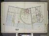
Brooklyn, Vol. 2, Double Page Plate No. 19; Part of Ward 30, Section 18; [Map bounded by 2nd Ave., Ridge Blvd.; Including 74th St., 60th St.] / by and under the direction of Hugo Ullitz.
From Volume 2.
Plate 7: [Bounded by 60th Street, Seventh Avenue, 66th Street, Stewart Avenue, 75th Street, Fourth Avenue, 72nd Street, Second Avenue, 71st Street, First Avenue, Mackay Place, Shore Road and New York Bay Pier Line.]
from Robinson's atlas of Kings County, New York : compiled from official records ... / under the direction of E. Robinson.
Part of Ward 30, Land Map Section, No. 18. Volume 2, Brooklyn Borough, New York City.
from Atlas of the Brooklyn borough of the City of New York : originally Kings Co.; complete in three volumes ... based upon official maps and plans ... / by and under the supervision of Hugo Ullitz, C.E.
Brooklyn, Vol. 1, Double Page Plate No. 35; Part of Ward 8, Section 3; [Map bounded by 52nd St., 5th Ave.; Including 60th St., 1st Ave.]
from Wards 1, 2, 3, 4, 5, 6, 8, 9, 10, 12 & 22.
Brooklyn, Vol. 6, Double Page Plate No. 11; Part of Ward 30, Section 18; [Map bounded by 5th Ave., Bayridge Ave., Ridge Blvd.; Including 2nd Ave., 60th St.]
from Ward 30.
Plate 18: Bounded by 40th Street, Eighth Avenue, 48th Street, Seventh Street (New Utrecht), Seventh Avenue, 59th Street and (New York Bay) First Avenue.
from Atlas of the entire city of Brooklyn, complete in one volume. From actual surveys and official records by G. W. Bromley & Co.
Plan of Bay Ridge parkway.
From Brooklyn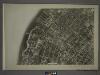
22A - N.Y. City (Aerial Set).
from Sectional aerial maps of the City of New York / [photographed and assembled under the direction of the chief engineer, July 1st, 1924].
[Sheet 1: Map encompassing Sunset Park, Greenwood Cemetery, Gowanus Canal and Greenwood Heights.]
from Map of the city of Brooklyn : being the former cities of Brooklyn & Williamsburgh and the town of Bushwick, as consolidated January 1st, 1855 by an act of the legislature of the State of New York ... showing also a part of the City of New York.
Plan of the city of Brooklyn, L.I. / by William Perris.
from Brooklyn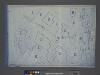
Area District Map Section No. 22; Area district map / City of New York, Board of Estimate and Apportionment.
from Area district map / City of New York, Board of Estimate and Apportionment. New York (N.Y.). Board of Estimate and Apportionment,
Use District Map Section No. 22; Use district map / City of New York, Board of Estimate and Apportionment.
from Use district map / City of New York, Board of Estimate and Apportionment. New York (N.Y.). Board of Estimate and Apportionment,
Height District Map Section No. 22; Height district map / City of New York, Board of Estimate and Apportionment.
from Height district map / City of New York, Board of Estimate and Apportionment. New York (N.Y.). Board of Estimate and Apportionment,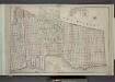
Brooklyn, Double Page Section 6; [Including Wards 8, 22]
from Farm line map of the city of Brooklyn, from official records and surveys; comp. and drawn by Henry Fulton.
Key
From Atlas 95. Vol. 11, 1905.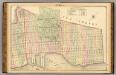
Sec. 6. Brooklyn map.
1 : 6000 Fulton, Henry; J.B. Beers & Co.
Plan of the city of Brooklyn, L.I. / by William Perris.
from Brooklyn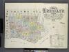
Insurance maps of the borough of Brooklyn city of New York. V.1. Published by the Sanborn Map Co., 11 Broadway, New York. 1886.
From Atlas 63. Vol. 1, 1886.
Area District Map Section No. 16
from Area district map / City of New York, Board of Estimate and Apportionment.
Use District Map Section No. 16
from Use district map / City of New York, Board of Estimate and Apportionment.
Jersey City, V. 1, Double Page Plate No. 24 [Map bounded by Ocean Ave., Linden Ave., Morris Canal, Avenue C] / compiled under the direction of and published by G.M. Hopkins Co.
From V. 1
Plan of the city of New York in North America : surveyed in the years 1766 & 1767 / B. Ratzer, lieutt. in His Majestys 60th or Royal American Regt. ; Thos. Kitchin, sculpt., engraver to His Late Royal Highness, the Duke of York, &c.
From Manhattan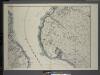
![Brooklyn V. 11, 1918 of New Sheet Map No. 34 [Map bounded by 59th St., 2nd Ave., 63rd St., 1st Ave.]](https://images-0.georeferencer.com/images/iiif/281387265664/full/,300/0/native.jpg)

