Maps of Kings County
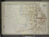
Brooklyn, Vol. 7, Double Page Plate No. 33; Part of Ward 31, Section 21; [Map bounded by Ocean Parkway, Sheepsheadbay Road, W. 8th St.; Including Shell Road, Coney Island Creek, Avenue Z]
from Ward 31.
Brooklyn Vol. B Plate No. 179 [Map bounded by Canal Ave., Coney Island Creek, Cortland St., Sheepshead Bay Road]
From Atlas 62. Vol. B, 1895.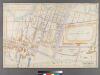
Part of Coney Island, Town of Gravesend.
from Robinson's atlas of Kings County, New York : compiled from official records ... / under the direction of E. Robinson.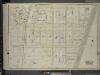
Brooklyn, Vol. 7, Double Page Plate No. 32; Part of Ward 31, Section 21; [Map bounded by Avenue W, Ocean Parkway, Avenue Z; Including W. 6th St., 86th St.]
from Ward 31.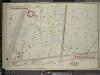
Brooklyn, Vol. 7, Double Page Plate No. 36; Part of Ward 31, Sections 21 & 22; [Map bounded by Avenue Z, E. 13th St.; Including Sheepshead Bay Road, Ocean Parkway]
from Ward 31.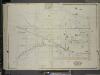
Brooklyn, Vol. 7, Double Page Plate No. 31; Part of Ward 31, Section 21; [Map bounded by W. 6th St., W. 8th St., Neptune Ave.; Including Stillwell Ave., W. 15th St., Canal Ave., Avenue Y]
from Ward 31.
Brooklyn Vol. B Plate No. 182 [Map bounded by Sheepshead Bay Road, Ocean Parkway, Sea Breeze Ave.]
From Atlas 62. Vol. B, 1895.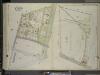
Brooklyn, Vol. 7, Double Page Plate No. 34; Part of Ward 31, Section 21; [Map bounded by Sheepshead Bay Road, Ocean Parkway; Including Atlantic Ocean, W. 5th St.]; Sub Plan; [Map bounded by Sheepshead Bay Road, E. 5th St., Seabreeze Ave., C
from Ward 31.
Brooklyn Vol. B Plate No. 178 [Map bounded by Sheepshead Bay Road, W.5th St., Surf Ave.]
From Atlas 62. Vol. B, 1895.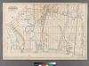
Part of the Town of Gravesend, Kings Co., N.Y.
from Robinson's atlas of Kings County, New York : compiled from official records ... / under the direction of E. Robinson.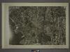
28B - N.Y. City (Aerial Set).
from Sectional aerial maps of the City of New York / [photographed and assembled under the direction of the chief engineer, July 1st, 1924].
Plate 19: Part of Section 21 - Coney Island.
from Atlas of the borough of Brooklyn, city of New York : from actual surveys and official plans by George W. and Walter S. Bromley.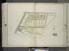
Brooklyn, Vol. 3, Double Page Plate No. 19; Part of Ward 31, Section 21; [Map bounded by Neptune Ave.; Including Atlantic Ocean, Ocean Parkway] / by and under the direction of Hugo Ullitz.
From Volume 3
Unionville Guntherville, Town of Gravesend, Kings Co. - Gravesend, Town of Gravesend, Kings Co. - Part of Town of Gravesend, Kings Co. - Flatlands, Town of Flatlands, Kings Co. - New Utrecht, Tn of New Utrecht, Kings Co.
from Atlas of Long Island, New York. From recent and actual surveys and records.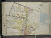
Brooklyn, Vol. 7, Double Page Plate No. 30; Part of Ward 31, Section 21; [Map bounded by E. 5th St., Atlantic Ocean, Stillwell Ave.; Including Neptune Ave., W. 8th St., Sheephead Road]
from Ward 31.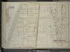
Brooklyn, Vol. 7, Double Page Plate No. 37; Part of Ward 31, Sections 21 & 22; [Map bounded by Avenue W, E. 15th St.; Including Avenue Z, Ocean Parkway]
from Ward 31.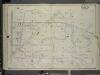
Brooklyn, Vol. 7, Double Page Plate No. 21; Part of Ward 31, Section 21; [Map bounded by W. 6th St., Avenue Y; Including Stillwell Ave., Avenue U]
from Ward 31.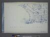
Use District Map Section No. 28; Use district map / City of New York, Board of Estimate and Apportionment.
from Use district map / City of New York, Board of Estimate and Apportionment. New York (N.Y.). Board of Estimate and Apportionment,
Height District Map Section No. 28; Height district map / City of New York, Board of Estimate and Apportionment.
from Height district map / City of New York, Board of Estimate and Apportionment. New York (N.Y.). Board of Estimate and Apportionment,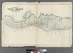
Map of Coney Island, New York.
from Atlas of the entire city of Brooklyn, complete in one volume. From actual surveys and official records by G. W. Bromley & Co.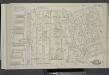
Vol. 5. Plate, C. [Map bound by Poplar St., Sands St., Jay St., Pearl St., Johnson St., Pierrepont St., East River; Including Middagh St., High St., Cranberry St., Orange St., Nassau St., Pineapple St., Concord St., Clark St., Tillary St., Love Lane, Fur
from Detailed estate and old farm line atlas of the city of Brooklyn : complete in six volumes ... from official records, private plans, and actual surveys ... / by G.M. Hopkins, C.E.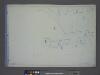
Area District Map Section No. 28
from Area district map / City of New York, Board of Estimate and Apportionment.
Coney Island, Gravesend, Sea Gate. (cont.)
From District 13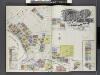
Insurance Maps of Brooklyn New York Sanborn Perris map co. 113 Broadway, New York. Volume "B" 1895.
From Atlas 62. Vol. B, 1895.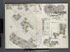
Insurance Maps of Brooklyn New York Sanborn Perris map co. 113, Broadway, New York. Volume "A" 1893.
From Atlas 61. Vol. A, 1893.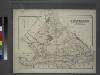
Gravesend. Kings Co. L.I.
from Atlas of Long Island, New York. From recent and actual surveys and records.
Index to Volume Seven. Atlas of the Borough of Brooklyn. Sections 20, 21 & 22. Ward 31. City of New York. E. Belcher Hyde, 97 Liberty St., Brooklyn Borough. 1907.
from Ward 31.
East Astoria, part of Long Island City, Queens Co.
from Atlas of Long Island, New York. From recent and actual surveys and records.
Flatlands. Kings Co. L.I.
From Atlas of Long Island, New York. From recent and actual surveys and records.
Coney Island
1 : 24000
Coney Island
1 : 24000
Coney Island
1 : 24000
Coney Island
1 : 24000
Coney Island
1 : 24000
Coney Island
1 : 24000
![Brooklyn, Vol. 7, Double Page Plate No. 33; Part of Ward 31, Section 21; [Map bounded by Ocean Parkway, Sheepsheadbay Road, W. 8th St.; Including Shell Road, Coney Island Creek, Avenue Z]](https://images-2.georeferencer.com/images/iiif/744895070707/full/,300/0/native.jpg)

