Maps of Kings County
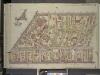
Brooklyn, Vol. 3, Double Page Plate No. 24; Part of Ward 27, Section 11; [Map bounded by Central Ave., Hart St., Lawton St.; Including Broadway, Flushing Ave.]; Sub Plan [Map bounded by Flushing Ave., Broadway, Sumner Pl.]
from Wards 13, 14, 15, 16, 17, 18, 19, 27 & 28.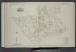
Vol. 2. Plate, I. [Map bound by Flushing Ave., Bushwick Ave., Varet St., Bogart St., Central Ave., Melrose St., Adams St., Broadway; Including Cooke St., White St., Yates Pl., Fayette St., Ellery St., Park Pl., Locust St., Belvidere St., Wall St., Montei
from Detailed estate and old farm line atlas of the city of Brooklyn : complete in six volumes ... from official records, private plans, and actual surveys ... / by G.M. Hopkins, C.E.
Vol. 2. Plate, L. [Map bound by Central Ave., Himrod St., La Fayette Ave., Broadway, Adams St., Melrose St.; Including Evergreen Ave., Central Pl., Bushwick Ave., Bremen St., Myrtle Ave., Jefferson St., Troutman St., Ditman St., Myrtle St., Suydam St., E
from Detailed estate and old farm line atlas of the city of Brooklyn : complete in six volumes ... from official records, private plans, and actual surveys ... / by G.M. Hopkins, C.E.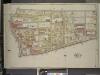
Brooklyn, Vol. 3, Double Page Plate No. 23; Part of Ward 18, Section 10; [Map bounded by Johnson Ave., Varick Ave.; Including Flushing Ave., Bushwick Ave., Bushwick Pl.]
from Wards 13, 14, 15, 16, 17, 18, 19, 27 & 28.
Brooklyn V. 9, Plate No. 19 [Map bounded by Willoughby Ave., Central Ave., Stockholm St., Evergreen Ave.]
From Atlas 90. Vol. 9, 1907.
Brooklyn V. 9, Plate No. 39 [Map bounded by Irving Ave., Willoughby Ave., Hamburg Ave., Melrose St.]
From Atlas 90. Vol. 9, 1907.
Brooklyn V. 3, Plate No. 65 [Map bounded by Myrtle Ave., Sumner Ave., De Kalb Ave., Throop Ave.]
From Atlas 71. Vol. 3, 1918.
Part of Wards 18 & 27. Land Map Sections, Nos. 18 & 27. Volume 1, Brooklyn Borough, New York City.
from Atlas of the Brooklyn borough of the City of New York : originally Kings Co.; complete in three volumes ... based upon official maps and plans ... / by and under the supervision of Hugo Ullitz, C.E.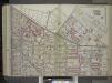
Brooklyn, Vol. 1, 2nd Part, Double Page Plate No. 38; Part of Wards 18 & 27, Section 10-11; [Map bounded by Flushing Ave., Morgan Ave., Meserole St., Gardner Ave.; Including Johnson Ave., Cypress Ave., De Kalb Ave., Broadway]; Sub Plan [Map bounded by...
From Volume 1
Plate 29: Bounded by Flushing Avenue, Central Avenue, Himrod Street, Evergreen Avenue, Harman Street, Bushwick Street, Greene Street, Broadway, Lexington Avenue and Nostrand Avenue.
from Atlas of the entire city of Brooklyn, complete in one volume. From actual surveys and official records by G. W. Bromley & Co.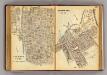
168-169 Sherman Park.
1 : 7200 G.W. Bromley & Co.
Plate 17: Bounded by Flushing Avenue, Knickerbocker Avenue, Grattan Street, Flushing Avenue, Covert Avenue, Myrtle Avenue, Cypress Street, Standhope Street, St. Nicholas Avenue, Harman Street, Bushwick Avenue and Bremen Street.
from Robinson's atlas of the city of Brooklyn, New York : embracing all territory within its corporate limits; from official records ... / by and under the supervision of E. Robinson and R.H. Pidgeon, civil engineers.
Plate 18: [Bounded by Flushing Avenue, Bremen Street, Bushwick Avenue, Willoughby Avenue, Broadway, Hart Street, Stuyvesant Avenue, Lafayette Avenue and Nostrand Avenue.]
from Atlas of the borough of Brooklyn, city of New York : from actual surveys and official plans by George W. and Walter S. Bromley.
Plate 18: Part of Wards 18 & 21. Brooklyn, N.Y.
from Atlas of the city of Brooklyn, New York.
Plate 15: Part of Wards 16, 18., & 19. Brooklyn, N.Y.
from Robinson's atlas of the city of Brooklyn, New York : embracing all territory within its corporate limits; from official records ... / by and under the supervision of E. Robinson and R.H. Pidgeon, civil engineers.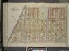
Brooklyn, Vol. 3, Double Page Plate No. 25; Part of Wards 27 & 28, Section 11; [Map bounded by Irving Ae., Stanhope St.; Including Central Ave., Flushing Ave.]
from Wards 13, 14, 15, 16, 17, 18, 19, 27 & 28.
Part of Wards 16 & 18. Land Map Section, No. 10, Volume 1, Brooklyn Borough, New York City.
from Atlas of the Brooklyn borough of the City of New York : originally Kings Co.; complete in three volumes ... based upon official maps and plans ... / by and under the supervision of Hugo Ullitz, C.E.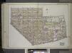
Brooklyn, Vol. 1, 2nd Part, Double Page Plate No. 37; Part of Wards 16 & 18, Section 10 & 8; [Map bounded by Ten Eyck St., Bushwick Ave., Meserole St., Morgan Ave; Including Flushing Ave., Broadway, Union Ave.] / by and under the direction of Hugo Ull...
From Volume 1
Part of Wards 19 & 21. Land Map Sections, No. 6 & 8, Volume 1, Brooklyn Borough, New York City.
from Atlas of the Brooklyn borough of the City of New York : originally Kings Co.; complete in three volumes ... based upon official maps and plans ... / by and under the supervision of Hugo Ullitz, C.E.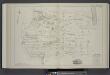
Vol. 2. Plate, G. [Map bound by Meserole St., Canal, Randolph St., Johnson Aver, Vandervoort Ave., Thames St., Varet St., Bushwick Ave., Old Bushwick Ave.; Including Montrose Ave., Boerum St., Ingraham St., Mc Kibbin St., Seigel St., Harrison Pl., Gratta
from Detailed estate and old farm line atlas of the city of Brooklyn : complete in six volumes ... from official records, private plans, and actual surveys ... / by G.M. Hopkins, C.E.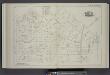
Vol. 2. Plate, J. [Map bound by Bogart St., Thames St., Vandervoort Aver, Ingraham St., Gardner Aver, Flushing Ave., Wyckoff Ave., Starr St., Central Ave.; Including Rock St., Forest St., Prospect St., George St., Melrose St., Jefferson St., Troutman St.
from Detailed estate and old farm line atlas of the city of Brooklyn : complete in six volumes ... from official records, private plans, and actual surveys ... / by G.M. Hopkins, C.E.
Brooklyn, Vol. 1, Double Page Plate No. 25; Part of Wards 21 & 23, Section 6; [Map bounded by Stockton St., Broadway, Reid Ave., Monroe St., Styvensant Ave.; Including Gates Ave., Sumner Ave., Quincy St., Marcy Ave.] / by and under the direction of Hu...
From Volume 1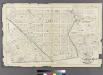
Plate 28: Part of Wards 16, 18 & 19. City of Brooklyn.
from Atlas of the entire city of Brooklyn, complete in one volume. From actual surveys and official records by G. W. Bromley & Co.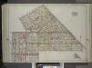
Brooklyn, Vol. 1, 2nd Part, Double Page Plate No. 30; Part of Wards 19 & 21, Section 6 & 8; [Map bounded by Heyward St., Broadway, Lewis Ave., Stockton St., Marcy Ave.; Including Willoughby Ave., Bedford Ave., Flushing Ave., Lee Ave.]; Sub Plan [Map b...
From Volume 1
Double Page Plate No. 25: [Bounded by Stockton Street, Broadway, Reid Avenue, Monroe Street, Stuyvesant Avenue, Gates Avenue, Lewis Avenue, Quincy Street, Throop Avenue, Lexington Avenue and Marcy Avenue.]
from Atlas of the Brooklyn borough of the City of New York : originally Kings Co.; complete in three volumes ... based upon official maps and plans ... / by and under the supervision of Hugo Ullitz, C.E.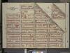
Brooklyn, Vol. 2, Double Page Plate No. 16; Part of Wards 21, 23 & 25, Section 6; [Map bounded by Vernon Ave., Broadway, Patchen Ave.; Including Lexington Ave., Sumner Ave., Hart St., Lewis Ave.]; Sub Plan; [Map bounded by Broadway, Vernon Av
from Wards 7, 11, 20, 21, 23, 24 & 25.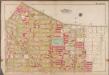
Plate 17: [Bounded by Flushing Avenue, Purdy Place, Willoughby Avenue, Cypress Avenue, Himrod Street, St. Nicholas Avenue, Harman Street, Bushwick Avenue and Bremen Street.]; Atlas of the borough of Brooklyn, city of New York: from actual surveys and official plans by George W. and Walter S. Bromley.
from Atlas of the borough of Brooklyn, city of New York : from actual surveys and official plans by George W. and Walter S. Bromley. G.W. Bromley & Co.,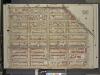
Brooklyn, Vol. 2, Double Page Plate No. 11; Part of Ward 21, Section 6; [Map bounded by Flushing Ave., Broadway, Lewis Ave.; Including Hart St., Marcy Ave.]
from Wards 7, 11, 20, 21, 23, 24 & 25.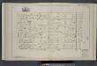
Vol. 2. Plate, M. [Map bound by Starr St., Wyckoff Ave., Stanhope St., Central Ave.; Including Myrtle St., Suydam St., Elm St., De Kalb Ave., Stockholm St., Myrtle Ave., Hamburg St., Knickerbocker Ave., Irving Ave.]
from Detailed estate and old farm line atlas of the city of Brooklyn : complete in six volumes ... from official records, private plans, and actual surveys ... / by G.M. Hopkins, C.E.
![Brooklyn, Vol. 3, Double Page Plate No. 24; Part of Ward 27, Section 11; [Map bounded by Central Ave., Hart St., Lawton St.; Including Broadway, Flushing Ave.]; Sub Plan [Map bounded by Flushing Ave., Broadway, Sumner Pl.]](https://images-2.georeferencer.com/images/iiif/910864755054/full/,300/0/native.jpg)

