Maps of Kings County
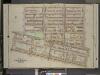
Brooklyn, Vol. 2, Double Page Plate No. 14; Part of Wards 23 & 25, Section 6; [Map bounded by Macon St., Patchen Ave., Buffalo Ave.; Including Atlantic Ave., Troy Ave., Fulton St., Lewis Ave.]
from Wards 7, 11, 20, 21, 23, 24 & 25.
Vol. 1. Plate, J. [Map bound by Decatur St., Patchen Ave., Buffalo Ave., Pacific Ave., Dean St., Troy Ave., Yates Ave.; Including Bainbridge St., Chauncey, Marion St., Sumpter St., Fulton St., Herkimer St., Atlantic Ave., Pacific Ave., Lewis Ave., Schene
from Detailed estate and old farm line atlas of the city of Brooklyn : complete in six volumes ... from official records, private plans, and actual surveys ... / by G.M. Hopkins, C.E.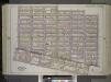
Brooklyn, Vol. 1, Double Page Plate No. 23; Part of Ward 23, Section 6; [Map bounded by Quincy St., Sumner Ave., Gates Ave., Styvensant Ave., Monroe St., Reid Ave., Fulton St.; Including Utica Ave., Atlantic Ave., New York Ave., Fulton St., Marcy Ave....
From Volume 1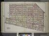
Brooklyn, Vol. 1, Double Page Plate No. 22; Part of Ward 25, Section 6; [Map bounded by Hanock St., Bainbridge St., Broadway, Rockaway Ave.; Including Atlantic Ave., Utica Ave., Fulton St., Reid Ave.] / by and under the direction of Hugo Ullitz.
From Volume 1
Part of Wards 23 & 25. Land Map Section, No. 6, Volume 1, Brooklyn Borough, New York City.
from Atlas of the Brooklyn borough of the City of New York : originally Kings Co.; complete in three volumes ... based upon official maps and plans ... / by and under the supervision of Hugo Ullitz, C.E.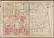
Plate 25: [Bounded by Rochester Avenue, East New York Avenue, Kingston Avenue and Atlantic Avenue.]; Atlas of the borough of Brooklyn, city of New York: from actual surveys and official plans by George W. and Walter S. Bromley.
from Atlas of the borough of Brooklyn, city of New York : from actual surveys and official plans by George W. and Walter S. Bromley. G.W. Bromley & Co.,
Part of Ward 23. Land Map Section, No. 6, Volume 1, Brooklyn Borough, New York City.
from Atlas of the Brooklyn borough of the City of New York : originally Kings Co.; complete in three volumes ... based upon official maps and plans ... / by and under the supervision of Hugo Ullitz, C.E.
[Plate 19: Bounded by Stuyvesant Avenue, Fulton Street, Utica Avenue, Atlantic Avenue, Brooklyn Avenue, Fulton Street, Tompkins Street and Lafayette Avenue.]
from Robinson's atlas of the city of Brooklyn, New York : embracing all territory within its corporate limits; from official records ... / by and under the supervision of E. Robinson and R.H. Pidgeon, civil engineers.
Plate 24: Part of Ward 24 & 25. Brooklyn, N.Y.
from Robinson's atlas of the city of Brooklyn, New York : embracing all territory within its corporate limits; from official records ... / by and under the supervision of E. Robinson and R.H. Pidgeon, civil engineers.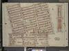
Brooklyn, vol. 2, Double Page Plate No. 13; Part of Ward 23, Section 6; [Map bounded by Putnan Ave., Throop Ave., Jefferson Ave., Lewis Ave., Chauncey St.; Including Fulton St., Troy Ave., Atlantic Ave., Brooklyn Ave., Tompkins Ave.]; Sub
from Wards 7, 11, 20, 21, 23, 24 & 25.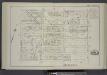
Vol. 1. Plate, F. [Map bounded by Madison St., Ralph Ave., Decatur St., Stuyvesant Ave.; Including Putman St., Jefferson St., Hancock St., Halsey St., Macon St., Mc Donough St., Reid Ave., Patchen Ave.]
from Detailed estate and old farm line atlas of the city of Brooklyn : complete in six volumes ... from official records, private plans, and actual surveys ... / by G.M. Hopkins, C.E.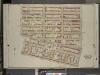
Brooklyn, Vol. 2, Double Page Plate No. 18; Part of Ward 25, Section 6; [Map bounded by Decatur St., Saratoga Ave., Hull St.; Including Atlantic Ave., Buffalo Ave., Fulton St., Patchen Ave.]
from Wards 7, 11, 20, 21, 23, 24 & 25.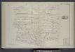
Vol. 1. Plate, K. [Map bound by Decatur St., Saratoga Ave., Herkimer St., Howard Ave., Atlantic Ave., Buffalo Ave., Patchen Ave.; Including Bainbridge St., Chauncey St., Marion St., Sumpter St., Mc Dougall St., Fulton St., Hull St., Herkimer St., Ralph A
from Detailed estate and old farm line atlas of the city of Brooklyn : complete in six volumes ... from official records, private plans, and actual surveys ... / by G.M. Hopkins, C.E.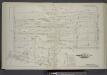
Vol. 1. Plate, E. [Map bounded by Putnam Ave., Stuyvesant Ave., Decatur St., Tates Ave., Herkimer St., Brooklyn Ave., Tompkins Ave.; Including Jefferson St., Hancock St., Halsey St., Fulton St., Macon St., Mc Donough St., Kingston Ave., Albany Ave.]
from Detailed estate and old farm line atlas of the city of Brooklyn : complete in six volumes ... from official records, private plans, and actual surveys ... / by G.M. Hopkins, C.E.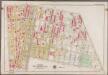
Plate 24: [Bounded by Saratoga Avenue, East New York Avenue, Rochester Avenue, Atlantic Avenue, Utica Avenue, Fulton Street, Reid Avenue and Chauncey Street.]; Atlas of the borough of Brooklyn, city of New York: from actual surveys and official plans by George W. and Walter S. Bromley.
from Atlas of the borough of Brooklyn, city of New York : from actual surveys and official plans by George W. and Walter S. Bromley. G.W. Bromley & Co.,
Brooklyn, Vol. 2, Double Page Plate No. 15; Part of Wards 23 & 25, Section 6; [Map bounded by Lexington Ave., Patchen Ave., Macon St.; Including Lewis Ave., Putnam Ave., Sumner Ave.]
from Wards 7, 11, 20, 21, 23, 24 & 25.
Vol. 1. Plate, P. [Map bound by Dean St., Pacific St., Buffalo Ave., Douglass St., Troy Ave.; Including Bergen St., St. Marks St., Prospect Pl., Park Pl., Butler St., Schenectady Ave., Utica Ave., Rochester Ave.]
from Detailed estate and old farm line atlas of the city of Brooklyn : complete in six volumes ... from official records, private plans, and actual surveys ... / by G.M. Hopkins, C.E.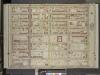
Brooklyn, Vol. 2, Double Page Plate No. 22; Part of Ward 24, Section 5; [Map bounded by Atlantic Ave.; Including Ralph Ave., St. Johns PL. (Douglass St.), Schenectady Ave.]
from Wards 7, 11, 20, 21, 23, 24 & 25.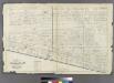
Plate 31: Part of Wards 23 & 25. City of Brooklyn.
from Atlas of the entire city of Brooklyn, complete in one volume. From actual surveys and official records by G. W. Bromley & Co.
17A - N.Y. City (Aerial Set).
from Sectional aerial maps of the City of New York / [photographed and assembled under the direction of the chief engineer, July 1st, 1924].
Brooklyn, Section 8; [Including Wards 24]
from Farm line map of the city of Brooklyn, from official records and surveys; comp. and drawn by Henry Fulton.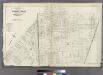
[Plate 32: Bounded by Greene Avenue, Bushvick Avenue, Himrod Street, Centrat Avenue, Greene Avenue, Myrtle Avenue, Bleecker Street, Wyckoff Avenue, Cornelia Street, Irving Avenue, Eldert Street, Knickerbocker Avenue, Schaffer Street, Broadway, Hopkinson
from Atlas of the entire city of Brooklyn, complete in one volume. From actual surveys and official records by G. W. Bromley & Co.
Plate 20: Part of Wards 18, 21 & 25. Brooklyn, N.Y.
from Atlas of the city of Brooklyn, New York.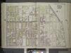
Brooklyn, Vol. 1, Double Page Plate No. 18; Part of Ward 24 & 29, Section 5; [Map bounded by Buffalo Ave., East New York Ave., Albany Ave., Atlantic Ave.] / by and under the direction of Hugo Ullitz.
From Volume 1
Double Page Plate No. 18: [Bounded by Albany Avenue, Atlantic Avenue, Buffalo Avenue and East New York Avenue.]
from Atlas of the Brooklyn borough of the City of New York : originally Kings Co.; complete in three volumes ... based upon official maps and plans ... / by and under the supervision of Hugo Ullitz, C.E.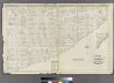
Plate 33: Part of Wards 23 & 25. City of Brooklyn.
from Atlas of the entire city of Brooklyn, complete in one volume. From actual surveys and official records by G. W. Bromley & Co.
Plate 25: Part of Ward 24. Brooklyn, N.Y.
from Robinson's atlas of the city of Brooklyn, New York : embracing all territory within its corporate limits; from official records ... / by and under the supervision of E. Robinson and R.H. Pidgeon, civil engineers.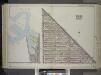
Brooklyn, Vol. 1, Double Page Plate No. 24; Part of Wards 21 & 25, Section 6; [Map bounded by Broadway, Hancock St., Reid Ave.]; Sub Plan [Map bounded by East River, Washington Ave., Flushing Ave., U.S. Navy Yard, Wallabout Channel] / by and under the...
From Volume 1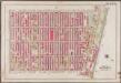
Plate 19: [Bounded by Stuyvesant Avenue, Fulton Street, Utica Avenue, Atlantic Avenue, Brooklyn Avenue, Fulton Street, Tompkins Avenue and Lafayette Avenue.]; Atlas of the borough of Brooklyn, city of New York: from actual surveys and official plans by George W. and Walter S. Bromley.
from Atlas of the borough of Brooklyn, city of New York : from actual surveys and official plans by George W. and Walter S. Bromley. G.W. Bromley & Co.,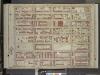
![Brooklyn, Vol. 2, Double Page Plate No. 14; Part of Wards 23 & 25, Section 6; [Map bounded by Macon St., Patchen Ave., Buffalo Ave.; Including Atlantic Ave., Troy Ave., Fulton St., Lewis Ave.]](https://images-2.georeferencer.com/images/iiif/989791354017/full/,300/0/native.jpg)

