Maps of Charleston County

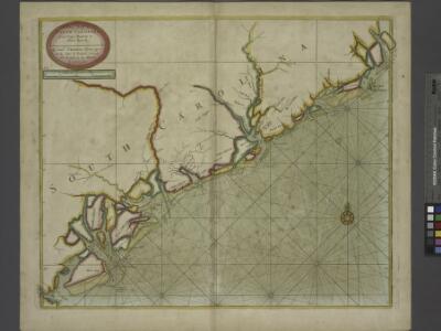
A large draft of SOUTH CAROLINA from cape Roman to Port Royall
from The sea-atlas : containing an hydrographical description of most of the sea-coasts of the known parts of the world.
Carte Particuliere De La Caroline [Karte], in: Atlas nouveau, contenant toutes les parties du monde [...], Bd. 2, S. 247.
1 Karte aus Atlas Sanson, Nicolas Jaillot, Alexis Hubert und Mortier, Pieter
Charleston District, South Carolina.
1 : 126720 Mills, Robert
Prang's Naval Expedition Maps: Port Royal, Charleston
Prang's Naval Expedition Maps: Port Royal, Charleston L. Prang & Co.
Our Brilliant Naval Victory.
1 : 221760 New York Herald
Colleton District, South Carolina.
1 : 126720 Mills, Robert
Map Of South Carolina (southeast portion)
1 : 380160 Wilson, John
Beaufort
1 : 100000
Beaufort
1 : 100000
Walterboro
1 : 100000
James Island
1 : 100000
Walterboro
1 : 100000
James Island
1 : 100000
Saint George
1 : 100000
Georgetown
1 : 100000
Georgetown
1 : 100000
Saint George
1 : 100000
Sumter
1 : 100000
Sumter
1 : 100000
Kingstree
1 : 100000
Kingstree
1 : 100000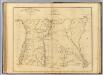
Williamsburgh District, South Carolina.
1 : 126720 Mills, Robert
Georgetown District, South Carolina.
1 : 126720 Mills, Robert
Frank Leslie's war maps
Leslie, Frank
James Island
1 : 250000
James Island
1 : 250000
James Island
1 : 250000
James Island
1 : 250000
Petersburg environs; Bentonville; Carolinas; Spanish Fort.
United States. War Department