Maps of Kings County
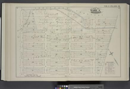
Vol. 4. Plate, M. [Map bound by Greenwood Cemetery, City Line, Forty-Fourth St., Fifth Ave.; Including Thirty-Seventh St., Thirty-Eighth St., Thirty-Ninth St., Fortieth St., Forty-First St., Forty-Second St., Forty-Third St., Sixth Ave., Seventh Ave., Ei
from Detailed estate and old farm line atlas of the city of Brooklyn : complete in six volumes ... from official records, private plans, and actual surveys ... / by G.M. Hopkins, C.E.
Brooklyn, Vol. 1, Double Page Plate No. 37; Part of Wards 8 & 30, Section 3; [Map bounded by 9th Ave., 49th St.; Including 6th Ave., 36th St.]
from Wards 1, 2, 3, 4, 5, 6, 8, 9, 10, 12 & 22.
Plate 34: Part of Ward 8. Brooklyn, N.Y.
from Robinson's atlas of the city of Brooklyn, New York : embracing all territory within its corporate limits; from official records ... / by and under the supervision of E. Robinson and R.H. Pidgeon, civil engineers.
Brooklyn, Vol. 1, Double Page Plate No. 10; Part of Wards 8 & 30, Section 3; [Map bounded by 9th Ave., 49th St., 8th Ave.; Including 60th St., 5th Ave., 39th St.] / by and under the direction of Hugo Ullitz.
From Volume 1
Double Page Plate No. 10: [Bounded by Sixth Ave., Thirty Ninth St.,Ninth Ave., Forty Ninth St., Eighth Ave. and Sixtieth St.]
from Atlas of the Brooklyn borough of the City of New York : originally Kings Co.; complete in three volumes ... based upon official maps and plans ... / by and under the supervision of Hugo Ullitz, C.E.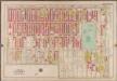
Plate 34: [Bounded by Fourth Avenue, 38th Street, Ninth Avenue, 49th Street, Eighth Avenue and 60th Street.]; Atlas of the borough of Brooklyn, city of New York: from actual surveys and official plans by George W. and Walter S. Bromley.
from Atlas of the borough of Brooklyn, city of New York : from actual surveys and official plans by George W. and Walter S. Bromley. G.W. Bromley & Co.,
Green-wood cemetery / surveyed by Edwd. Boyle C.E.
from Brooklyn
Part of Ward 8. Land Map Section, No. 3, Volume 1, Brooklyn Borough, New York City.
from Atlas of the Brooklyn borough of the City of New York : originally Kings Co.; complete in three volumes ... based upon official maps and plans ... / by and under the supervision of Hugo Ullitz, C.E.
Plate 35: Part of Ward 8. Brooklyn, N.Y.
from Robinson's atlas of the city of Brooklyn, New York : embracing all territory within its corporate limits; from official records ... / by and under the supervision of E. Robinson and R.H. Pidgeon, civil engineers.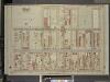
Brooklyn, Vol. 1, Double Page Plate No. 33; Part of Ward 8, Section 3; [Map bounded by 6th Ave., 44th St., 3rd Ave.; Including 32nd St., 5th Ave., 36th St.]
from Wards 1, 2, 3, 4, 5, 6, 8, 9, 10, 12 & 22.
Vol. 4. Plate, O. [Map bound by Forty-Fourth St., City Line, Fifty-Second St., Fourth Ave.; Including Forty-Fifth St., Forty-Sixth St., Forty-Seventh St., Forty-Eighth St., Forty-Ninth St., Fiftieth St., Fifty-First St., Fifth Ave., Sixth Ave., Seventh A
from Detailed estate and old farm line atlas of the city of Brooklyn : complete in six volumes ... from official records, private plans, and actual surveys ... / by G.M. Hopkins, C.E.
Green-Wood Cemetery.
1 : 3840 Anonymous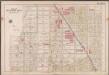
Plate 4: [Bounded by 43rd Street, 14th Avenue, 38th Street, 7th Avenue, 50th Street & 8th Avenue.]; Atlas of the borough of Brooklyn, city of New York: from actual surveys and official plans by George W. and Walter S. Bromley.
from Atlas of the borough of Brooklyn, city of New York : from actual surveys and official plans by George W. and Walter S. Bromley. G.W. Bromley & Co.,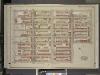
Brooklyn, Vol. 1, Double Page Plate No. 34; Part of Ward 8, Section 3; [Map bounded by 44th St., 6th Ave., 49th St.; Including 5th Ave., 42nd St., 2nd Ave.]
from Wards 1, 2, 3, 4, 5, 6, 8, 9, 10, 12 & 22.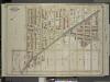
Brooklyn, Vol. 6, Double Page Plate No. 1; Part of Ward 30, Section 17; [Map bounded by 12th Ave., 49th St., 9th Ave.; Including 37th St., 10th Ave., 39th St.]
from Ward 30.
Vol. 4. Plate, L. [Map bound by Thirty-Sixth, Fifth Ave., Forty-Fourth St., Gowanus Bay; Including Third St., Forty-Fourth St., Thirty-Seventh St., Thirty-Eighth St., Thirty-Ninth St., Fortieth St., Forty-First St., Forty-Second St., Forty-Third St., Fir
from Detailed estate and old farm line atlas of the city of Brooklyn : complete in six volumes ... from official records, private plans, and actual surveys ... / by G.M. Hopkins, C.E.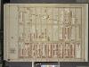
Brooklyn, Vol. 1, Double Page plate No. 36; Part of Wards 8 & 30, Section 3; [Map bounded by 8th Ave., 60th St.; Including 5th Ave., 49th St.]
from Wards 1, 2, 3, 4, 5, 6, 8, 9, 10, 12 & 22.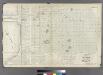
Plate 17: Part of Ward 8 City of Brooklyn.
from Atlas of the entire city of Brooklyn, complete in one volume. From actual surveys and official records by G. W. Bromley & Co.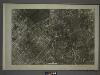
22B - N.Y. City (Aerial Set).
from Sectional aerial maps of the City of New York / [photographed and assembled under the direction of the chief engineer, July 1st, 1924].
[Sheet 1: Map encompassing Sunset Park, Greenwood Cemetery, Gowanus Canal and Greenwood Heights.]
from Map of the city of Brooklyn : being the former cities of Brooklyn & Williamsburgh and the town of Bushwick, as consolidated January 1st, 1855 by an act of the legislature of the State of New York ... showing also a part of the City of New York.
Plan of the city of Brooklyn, L.I. / by William Perris.
from Brooklyn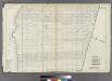
Plate 18: Bounded by 40th Street, Eighth Avenue, 48th Street, Seventh Street (New Utrecht), Seventh Avenue, 59th Street and (New York Bay) First Avenue.
from Atlas of the entire city of Brooklyn, complete in one volume. From actual surveys and official records by G. W. Bromley & Co.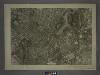
16D - N.Y. City (Aerial Set).
from Sectional aerial maps of the City of New York / [photographed and assembled under the direction of the chief engineer, July 1st, 1924].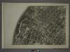
22A - N.Y. City (Aerial Set).
from Sectional aerial maps of the City of New York / [photographed and assembled under the direction of the chief engineer, July 1st, 1924].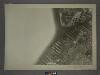
16C - N.Y. City (Aerial Set).
from Sectional aerial maps of the City of New York / [photographed and assembled under the direction of the chief engineer, July 1st, 1924].
Plan of the city of Brooklyn, L.I. / by William Perris.
from Brooklyn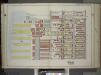
Brooklyn, Vol. 1, Double Page Plate No. 8; Part of Ward 8, Section 3; [Map bounded by 2nd Ave., 37th St., 5th Ave., 49th St., Gowanus Bay] / by and under the direction of Hugo Ullitz.
From Volume 1
Part of Wards 29 & 30, Land Map Sections, Nos. 3, 16 & 17, Volume 2, Brooklyn Borough, New York City.
from Atlas of the Brooklyn borough of the City of New York : originally Kings Co.; complete in three volumes ... based upon official maps and plans ... / by and under the supervision of Hugo Ullitz, C.E.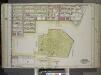
Brooklyn, Vol. 1, Double Page Plate No. 11; Part of Wards 8, 22, 29 & 30, Section 3; [Map bounded by Prospect Ave., 11th Ave., Terrace Pl., Gravesend Ave., 20th St.; Including 7th Ave., 23rd St., 6th Ave., 24th St., 5th Ave.]; and [Map bounded by 36th...
From Volume 1