Maps of East Atlantic Beach

Map of New-York Bay and Harbor and the environs / founded upon a trigonometrical survey under the direction of F.R. Hassler, superintendent of the Survey of the Coast of the United States ; triangulation by James Ferguson and Edmund Blunt assistants ; th
from New York harbor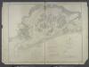
Jamaica Bay and Rockaway Inlet, Long Island, New York.
from U.S. Coast and Geodetic Survey. Nautical chart ; no. 542.
Coney Island
1 : 24000
Far Rockaway
1 : 24000
Far Rockaway
1 : 24000
Coney Island
1 : 24000
Coney Island
1 : 24000
Coney Island
1 : 24000
Coney Island
1 : 24000
Coney Island
1 : 24000
Far Rockaway
1 : 24000
Coney Island
1 : 24000
Far Rockaway
1 : 24000
Key
From Atlas 145a. Vol. 8, 1912.
Index to Volume Seven. Atlas of the Borough of Brooklyn. Sections 20, 21 & 22. Ward 31. City of New York. E. Belcher Hyde, 97 Liberty St., Brooklyn Borough. 1907.
from Ward 31.
Queens, Vol. 1, Double Page Plate No. 40; Part of Ward 5; Farrockaway; [map bounded by Jamaica Bay, Atlantic Ocean; Including Washington Ave.]
from Fourth and fifth wards: Jamaica and Rockaway.
Height District Map Section No. 30
from Height district map / City of New York, Board of Estimate and Apportionment.
Area District Map Section No. 30
from Area district map / City of New York, Board of Estimate and Apportionment.
Height District Map Section No. 29
from Height district map / City of New York, Board of Estimate and Apportionment.
Insurance Maps of Brooklyn New York Sanborn Perris map co. 113 Broadway, New York. Volume "B" 1895.
From Atlas 62. Vol. B, 1895.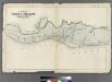
Map of Coney Island, New York.
from Atlas of the entire city of Brooklyn, complete in one volume. From actual surveys and official records by G. W. Bromley & Co.
Area District Map Section No. 29; Area district map / City of New York, Board of Estimate and Apportionment.
from Area district map / City of New York, Board of Estimate and Apportionment. New York (N.Y.). Board of Estimate and Apportionment,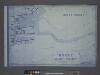
Use District Map Section No. 29; Use district map / City of New York, Board of Estimate and Apportionment.
from Use district map / City of New York, Board of Estimate and Apportionment. New York (N.Y.). Board of Estimate and Apportionment,
Use District Map Section No. 30; Use district map / City of New York, Board of Estimate and Apportionment.
from Use district map / City of New York, Board of Estimate and Apportionment. New York (N.Y.). Board of Estimate and Apportionment,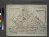
Gravesend. Kings Co. L.I.
from Atlas of Long Island, New York. From recent and actual surveys and records.
Key
From Atlas 145a. Vol. 8, 1912.
Coney Island, Gravesend, Sea Gate. (cont.)
From District 13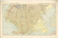
Hammods Atlas of New York City and the metropolitan district

Flatlands. Kings Co. L.I.
from Atlas of Long Island, New York. From recent and actual surveys and records.