Maps of Queens County
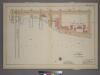
Plate 21, Part of Section 5: [Bounded by Avenue A, E. 67th Street, East River and E. 59th Street.]
from Atlas of the city of New York, borough of Manhattan. From actual surveys and official plans / by George W. and Walter S. Bromley.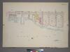
Plate 21, Part of Section 5: [Bounded by E. 65th Street, Avenue A, E. 67th Street and Exterior Street.]
from Atlas of the city of New York, borough of Manhattan. From actual surveys and official plans / by George W. and Walter S. Bromley.
Part of Section 5: Plate 108.
from Atlas of the borough of Manhattan, city of New York.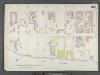
Manhattan, V. 6, Double Page Plate No. 120 [Map bounded by 1st Ave., E. 72nd St., East River, E. 63rd St.]
From Atlas 117. Vol. 6, 1892.
Plate 120: Map bounded by East 72nd Street, East River, East 63rd Street, First Avenue
from Maps of the city of New York.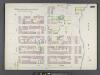
Manhattan, V. 6, Double Page Plate No. 109 [Map bounded by E. 63rd St., East River, E. 57th St., 2nd Ave.]
From Atlas 117. Vol. 6, 1892.
Plate 109: Map bounded by East 62nd Street, First Avenue, East 63rd Street, East River, East 57th Street, Second Avenue
from Maps of the city of New York.
Plate 105: Bounded by E. 65th Street, Avenue A, E. 60th Street, Second Avenue, E. 59th Street and Third Avenue.
from Atlas of the borough of Manhattan, city of New York.
Part of Section 5: Plate 109.
from Atlas of the borough of Manhattan, city of New York.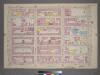
Plate 20, Part of Section 5: [Bounded by E. 65th Street, Avenue A, Third Avenue, E. 59th Street and Third Avenue.]
from Atlas of the city of New York, borough of Manhattan. From actual surveys and official plans / by George W. and Walter S. Bromley.
Plate 20, Part of Section 5: [Bounded by E. 65th Street, Avenue A, E. 59th Street and Third Avenue.]
from Atlas of the city of New York, borough of Manhattan. From actual surveys and official plans / by George W. and Walter S. Bromley.
[Plate 107: Bounded by E. 71st Street, Avenue A, E. 65th Street and Third Avenue.]
from Atlas of the borough of Manhattan, city of New York.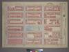
Plate 22, Part of Section 5: [Bounded by E. 71st Street, Avenue A, E. 65th Street and Third Avenue.]
from Atlas of the city of New York, borough of Manhattan. From actual surveys and official plans / by George W. and Walter S. Bromley.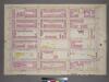
Plate 22, Part of Section 5: [Bounded by E. 71st Street, Avenue A, E. 65th Street and Third Avenue.]
from Atlas of the city of New York, borough of Manhattan. From actual surveys and official plans / by George W. and Walter S. Bromley.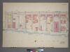
Plate 26, Part of Section 5: [Bounded by E. 67th Street, Avenue A, E. 76th Street and Exterior Street.]
from Atlas of the city of New York, borough of Manhattan. From actual surveys and official plans / by George W. and Walter S. Bromley.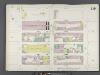
Manhattan, V. 6, Double Page Plate No. 119 [Map bounded by E. 67th St., 1st Ave., E. 62nd St., 3rd Ave.]
From Atlas 117. Vol. 6, 1892.
Plate 119: Map bounded by East 67th Street, First Avenue, East 62nd Street, Third Avenue
from Maps of the city of New York.
Plate 27: Bounded by E. 64th Street, Second Avenue, East River (Avenue A), E. 57th Street, and Lexington Avenue.
from Atlas of the city of New York, Manhattan Island. From actual surveys and official plans / by George W. and Walter S. Bromley.
Part of Section 5: New York City.
from Atlas of the city of New York, borough of Manhattan. From actual surveys and official plans / by George W. and Walter S. Bromley.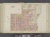
Manhattan, Double Page Plate No. 27 [Map bounded by E. 68th St., East River, E. 57th St., Lexington Ave.]
From Atlas of the city of New York, Manhattan Island. From actual surveys and official plans
[Plate 29: Bounded by Second Avenue, e. 84th Street, Avenue B, E. 79th Street, Avenue A (East River), and E. 68th Street.]
from Atlas of the city of New York, Manhattan Island. From actual surveys and official plans / by George W. and Walter S. Bromley.
Sackersdorff Farm Set.
from Maps of farms commonly called the Blue book, 1815 : drawn from the original on file in the street commissioner's office in the City of New York, together with lines of streets and avenues / laid out by John Randel, jr., 1819-20.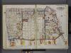
Queens, V. 2, Double Page Plate No. 2; Part of Long Island City, Ward 1; [Map bounded by Prospect St., 12th St., East River, Webster Ave.] / by and under the supervision of Hugo Ullitz.
From v. 2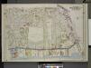
Queens, Vol. 2, Double Page Plate No. 2; Part of Long Island City Ward One (Part of Old Ward 1& 3). [Map bounded by Webster Ave., Freeman Ave., Vernon Ave., Payntar Ave., Beebe Ave., Wilbur Ave., Harris Ave., Jackson Ave., Nott Ave., West Ave.,
from Long Island City.
Queens, Vol. 2, Double Page Plate No. 2; Part of Long Island City Ward One (Part of Old Wards One and Three); [Map bounded by Prospect St., Harris Ave., Jackson Ave., 12th St., Vernon Ave., Division St., West Ave., Nott Ave., 13th St., 14th St., Engl
from First and second wards: Long Island City and Newtown.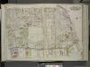
Queens, Vol. 2, Double Page Plate No. 2; Part of Long Island City Ward one (Part of Old Wards 1 and 3); [Map bounded by Prospect St., Harris Ave., Hunter Ave., Jackson Ave., 12th St., Division St., West Ave., 13th St., 14th St., Englis St., Bodine S
from First and second wards: Long Island City and Newtown.
Plate 19: Bounded by E. 76th Street, East River (Avenue A), E. 64th Street, and Fifth Avenue.
from Atlas of the city of New York : embracing all territory within its corporate limits from official records, private plans & actual surveys / by and under the supervision of E. Robinson & R.H. Pidgeon, civil engineers.
19. Ward 19.
1 : 2400 G.W. Bromley & Co.; Geo. W. Bromley & E. Robinson
Pl. 27: ward 19.
1 : 1800 Bromley, George Washington; Bromley, Walter Scott
![Plate 21, Part of Section 5: [Bounded by Avenue A, E. 67th Street, East River and E. 59th Street.]](https://images-0.georeferencer.com/images/iiif/692499586751/full/,300/0/native.jpg)

