Maps of Kings County
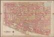
Plate 7: [Bounded by Lafayette Avenue, Marcy Avenue, Greene Avenue, Tompkins Avenue, Fulton Street, Brooklyn Avenue, Herkimer Street, Bedford Avenue, Atlantic Avenue & Washington Avenue]; Atlas of the borough of Brooklyn, city of New York: from actual surveys and official plans by George W. and Walter S. Bromley.
from Atlas of the borough of Brooklyn, city of New York : from actual surveys and official plans by George W. and Walter S. Bromley. G.W. Bromley & Co.,
Vol. 1. Plate, A. [Map bounded by Lafayette Ave., Tompkins Ave., Putnam Ave., Bedford Ave.; Including Van Buren St., Greene St., Lexington Ave., Quincy St., Gates Ave., Monroe St., Madison St., Nostrand Ave., Marcy Ave.]
from Detailed estate and old farm line atlas of the city of Brooklyn : complete in six volumes ... from official records, private plans, and actual surveys ... / by G.M. Hopkins, C.E.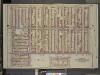
Brooklyn, Vol. 2, Double Page Plate No. 9; Part of Wards 7, 21 & 23, Sections 6 & 7; [Map bounded by Marcy Ave., Madison St., Bedford Ave.; Including De Kalb Ave., Franklin Ave., Willoughby Ave.]; Sub Plan; [Map bounded by Franklin Ave.
from Wards 7, 11, 20, 21, 23, 24 & 25.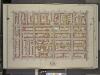
Brooklyn, Vol. 2, Double Page Plate No. 6; Part of Ward 7, Section 7; [Map bounded by De Kalb Ave., Bedford Ave.; Including Gates Ave., Washington Ave.]
from Wards 7, 11, 20, 21, 23, 24 & 25.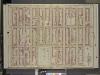
Brooklyn, Vol. 2, Double Page Plate No. 12; Part of Wards 21 & 23, Section 6; [Map bounded by Sumner Ave., Putnam Ave., Madison St.; Including Marcy Ave., Hart St.]
from Wards 7, 11, 20, 21, 23, 24 & 25.
Double Page Plate No. 26: [Bounded by Grand Avenue, Willoughby Avenue, Marcy Avenue, Fulton Street, New York Avenue and Atlantic Avenue.]
from Atlas of the Brooklyn borough of the City of New York : originally Kings Co.; complete in three volumes ... based upon official maps and plans ... / by and under the supervision of Hugo Ullitz, C.E.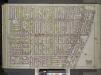
Brooklyn, Vol. 1, Double Page Plate No. 26; Part of Wards 7, 21 & 23, Sections 6 & 7; [Map bounded by Marcy Ave., Fulton St., New York Ave., Atlantic Ave.; Including Grand Ave., Lafayette Ave., Steuben St., Willoughby Ave.] / by and under the directio...
From Volume 1
Plate 7: Bounded by Lafayette Avenue, Marcy Avenue, Greene Avenue, Tompkins Avenue, Fulton Street, Brooklyn Avenue, Herkimer Street, Bedford Avenue, Atlantic Avenue and Washington Avenue.
from Robinson's atlas of the city of Brooklyn, New York : embracing all territory within its corporate limits; from official records ... / by and under the supervision of E. Robinson and R.H. Pidgeon, civil engineers.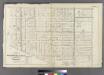
Plate 8: Part of Wards 7, 20, 21& 23. City of Brooklyn.
from Atlas of the entire city of Brooklyn, complete in one volume. From actual surveys and official records by G. W. Bromley & Co.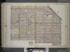
Brooklyn, Vol. 1, Double Page Plate No. 25; Part of Wards 21 & 23, Section 6; [Map bounded by Stockton St., Broadway, Reid Ave., Monroe St., Styvensant Ave.; Including Gates Ave., Sumner Ave., Quincy St., Marcy Ave.] / by and under the direction of Hu...
From Volume 1
Plate 8: Bounded by Flushing Wallabout Avenue, Nostrand Avenue, Lafayette Avenue and Clermont Avenue.
from Atlas of the city of Brooklyn, New York.
Double Page Plate No. 25: [Bounded by Stockton Street, Broadway, Reid Avenue, Monroe Street, Stuyvesant Avenue, Gates Avenue, Lewis Avenue, Quincy Street, Throop Avenue, Lexington Avenue and Marcy Avenue.]
from Atlas of the Brooklyn borough of the City of New York : originally Kings Co.; complete in three volumes ... based upon official maps and plans ... / by and under the supervision of Hugo Ullitz, C.E.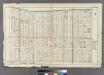
Plate 7: Bounded by Flushing Avenue, Nostrand Avenue, De Kalb Avenue and Clinton Avenue.
from Atlas of the entire city of Brooklyn, complete in one volume. From actual surveys and official records by G. W. Bromley & Co.
Vol. 1. Plate, B. [Map bounded by Lafayette Ave., Stuyvesant Ave., Putnam Ave., Tompkins Ave.; Including Van Buren St., Greene St., Lexington Ave., Quincy St., Gates Ave., Monroe St., Madison St., Throop Ave., Yates Ave., Lewis Ave.]
from Detailed estate and old farm line atlas of the city of Brooklyn : complete in six volumes ... from official records, private plans, and actual surveys ... / by G.M. Hopkins, C.E.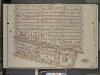
Brooklyn, Vol. 2, Double Page Plate No. 8; Part of Ward 23, Sectio 6; [Map bounded by Madison St., Tompkins Ave.; Including Brooklyn Ave., Atlantic Ave., Bedford Ave.]
from Wards 7, 11, 20, 21, 23, 24 & 25.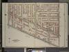
Brooklyn, Vol. 2, Double Page Plate No. 7; Part of Wards 7 & 23, Section 7; [Map bounded by Gates Ave., Bedford Ave.; Including Atlantic Ave., Washington Ave.]
from Wards 7, 11, 20, 21, 23, 24 & 25.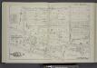
Vol. 1. Plate, D. [Map bounded by Putnam Ave., Tompkins Ave., Brooklyn Ave., New York Ave., Atlantic Ave., Franklin Ave., Brevoort Pl., Bedford Ave.; Including Jefferson St., Hancock St., Halsey St., Fulton St., Macon St., Herkimer St., Herkimer Pl., Mc
from Detailed estate and old farm line atlas of the city of Brooklyn : complete in six volumes ... from official records, private plans, and actual surveys ... / by G.M. Hopkins, C.E.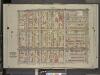
Brooklyn, Vol. 2, Double Page Plate No. 10; Part of Wards 7 & 21, Sections 6 & 7; [Map bounded by Flushing Ave., Marcy Ave.; Including Willoughby Ave., Kent Ave.]
from Wards 7, 11, 20, 21, 23, 24 & 25.
Brooklyn V. 3, Plate No. 64 [Map bounded by Myrtle Ave., Throop Ave., De Kalb Ave., Tompkins Ave.]
From Atlas 71. Vol. 3, 1918.
17A - N.Y. City (Aerial Set).
from Sectional aerial maps of the City of New York / [photographed and assembled under the direction of the chief engineer, July 1st, 1924].
[Sheet 2: Map encompassing Prospect Park, Windsor Terrace, Park Slope, Carroll Gardens, Gowanus Canal, Fort Greene, Clinton Hill and Prospect Heights.]
from Map of the city of Brooklyn : being the former cities of Brooklyn & Williamsburgh and the town of Bushwick, as consolidated January 1st, 1855 by an act of the legislature of the State of New York ... showing also a part of the City of New York.
[Sheet 3: Map encompassing Bedford Stuyvesant, Crown Heights and Weeksville.]
from Map of the city of Brooklyn : being the former cities of Brooklyn & Williamsburgh and the town of Bushwick, as consolidated January 1st, 1855 by an act of the legislature of the State of New York ... showing also a part of the City of New York.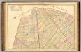
Sec. 7. Brooklyn map.
1 : 6000 Fulton, Henry; J.B. Beers & Co.
Plan of the city of Brooklyn, L.I. / by William Perris.
from Brooklyn
Plan of the city of Brooklyn, L.I. / by William Perris.
from Brooklyn
Sheet 6: Map encompassing Boerum Hill, Cobble Hill, Brooklyn Heights, Downtown Brooklyn, Vinegar Hill, Fort Greene, Clinton Hill, Brooklyn Navy Yard and South Williamsburg.
from Map of the city of Brooklyn : being the former cities of Brooklyn & Williamsburgh and the town of Bushwick, as consolidated January 1st, 1855 by an act of the legislature of the State of New York ... showing also a part of the City of New York.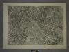
16B - N.Y. City (Aerial Set).
from Sectional aerial maps of the City of New York / [photographed and assembled under the direction of the chief engineer, July 1st, 1924].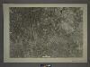
13C - N.Y. City (Aerial Set).
from Sectional aerial maps of the City of New York / [photographed and assembled under the direction of the chief engineer, July 1st, 1924].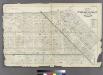
Plate 29: Bounded by Flushing Avenue, Central Avenue, Himrod Street, Evergreen Avenue, Harman Street, Bushwick Street, Greene Street, Broadway, Lexington Avenue and Nostrand Avenue.
from Atlas of the entire city of Brooklyn, complete in one volume. From actual surveys and official records by G. W. Bromley & Co.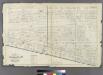
![Plate 7: [Bounded by Lafayette Avenue, Marcy Avenue, Greene Avenue, Tompkins Avenue, Fulton Street, Brooklyn Avenue, Herkimer Street, Bedford Avenue, Atlantic Avenue & Washington Avenue]; Atlas of the borough of Brooklyn, city of New York: from actual surveys and official plans by George W. and Walter S. Bromley.](https://images-2.georeferencer.com/images/iiif/605154067670/full/,300/0/native.jpg)

