Maps of Manhattan Community Board 9

[Plate 45: Bounded by W. 170th Street, Edgecombe Avenue (Harlem River, High Bridge Park), W. 158th Street, Hudson River (N.Y.C. and H.R.R.R.).]
from Atlas of the city of New York, borough of Manhattan. From actual surveys and official plans / by George W. and Walter S. Bromley.
Page 23: [Bounded by W. 177th Street, Harlem River, w. 157th Street and Hudson River.]
from Maps of farms commonly called the Blue book, 1815 : drawn from the original on file in the street commissioner's office in the City of New York, together with lines of streets and avenues / laid out by John Randel, jr., 1819-20.
Plate 169: Bounded by W. 173rd Street, Amsterdam Avenue, Edgecombe Avenue (High Bridge Park, Speedway, Harlem River), W. 167th Street, and Broadway.
from Atlas of the borough of Manhattan, city of New York.
Plate 164: Bounded by W. 162nd Street, Amsterdam Avenue, W. 157th Street and Broadway.
from Atlas of the borough of Manhattan, city of New York.
Part of Section 8: Plate 165
from Atlas of the borough of Manhattan, city of New York.
Part of Section 8: Plate 167
from Atlas of the borough of Manhattan, city of New York.
Part of Section 8: Plate 166
from Atlas of the borough of Manhattan, city of New York.
Part of Section 8: Plate 163
from Atlas of the borough of Manhattan, city of New York.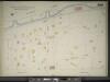
Manhattan, V. 11, Double Page Plate No. 260 [Map bounded by Hudson River, Boulevard, W. 155th St.]
From Atlas 42.61. Vol. 11-11 1/2, 1893.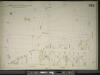
Manhattan, V. 11, Double Page Plate No. 262 [Map bounded by Fort Washington Ave., W. 170th St., Amsterdam Ave., W. 162nd St.]
From Atlas 42.61. Vol. 11-11 1/2, 1893.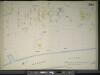
Manhattan, V. 11, Double Page Plate No. 263 [Map bounded by Amsterdam Ave., Harlem River, W. 162nd St.]
From Atlas 42.61. Vol. 11-11 1/2, 1893.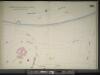
Manhattan, V. 11, Double Page Plate No. 261 [Map bounded by Hudson River, W. 170th St., Fort Washington Ave.]
From Atlas 42.61. Vol. 11-11 1/2, 1893.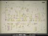
Manhattan, V. 11, Double Page Plate No. 259 [Map bounded by Boulevard, W. 162nd St., St. Nicholas Ave., W. 155th St.]
From Atlas 42.61. Vol. 11-11 1/2, 1893.
Part of Sections 7 & 8: Plate 160
from Atlas of the borough of Manhattan, city of New York.
Manhattan, V. 12, Plate No. 4 [Map bounded by W. 175th St., Amsterdam Ave., W. 170th St., 11th Ave.]
From Atlas 128. Vol. 12, 1900.
[Plate 168: Bounded by W. 173rd Street, St.Nicholas Avenue, W. 168th Street, ...(Harlem River, Fort Washington Park) Riverside Drive.]
from Atlas of the borough of Manhattan, city of New York.
Manhattan, V. 12, Plate No. 7 [Map bounded by St. Nicholas Ave., W. 173rd St., Amsterdam Ave., W. 170th St.]
From Atlas 129. Vol. 12, 1913.
Manhattan, V. 12, Plate No. 5 [Map bounded by Fort Washington Ave., W. 173rd St., St. Nicholas Ave., W. 170th St.]
From Atlas 129. Vol. 12, 1913.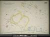
Manhattan, V. 11, Double Page Plate No. 258 [Map bounded by St. Nicholas Ave., Harlem River, W. 155th St.]
From Atlas 42.61. Vol. 11-11 1/2, 1893.
Manhattan, V. 11, Double Page Plate No. 255 [Map bounded by W. 155th St., Amsterdam Ave., W. 150th St., Hudson River]
From Atlas 42.61. Vol. 11-11 1/2, 1893.
Plate 171: Bounded by W. 178th Street, Amsterdam Avenue (Highbridge Park, Speedway), W. 173rd Street and Broadway.
from Atlas of the borough of Manhattan, city of New York.
Manhattan, V. 12, Plate No. 3 [Map bounded by W. 175th St., 11th Ave., W. 170th St., Fort Washington Ave.]
From Atlas 128. Vol. 12, 1900.
Manhattan, V. 12, Plate No. 8 [Map bounded by St. Nicholas Ave., W. 176th St., Amsterdam Ave., W. 173rd St.]
From Atlas 129. Vol. 12, 1913.
Manhattan, V. 12, Plate No. 3 [Map bounded by W. 175th St., Fort Washington Ave., W. 170th St., Haven Ave.]
From Atlas 129. Vol. 12, 1913.
Manhattan, V. 12, Plate No. 6 [Map bounded by Fort Washington Ave., W. 176th St., St. Nicholas Ave., W. 173rd St.]
From Atlas 129. Vol. 12, 1913.
Fort Washington section.
From Manhattan
Part of Section 8: New York City.
from Atlas of the city of New York, Manhattan Island. From actual surveys and official plans / by George W. and Walter S. Bromley.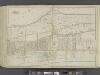
Manhattan, Double Page Plate No. 44 [Map bounded by Hudson River, Harlem River]
From Atlas of the city of New York, Manhattan Island. From actual surveys and official plans
Sheet 19: [Bounded by Hudson River Bulk Head Pier Line, Fort Washington, 10th Avenue (Harlem River Bulk Head Pier Line) and 160th Street.]
from Plan of New York City, from the Battery to Spuyten Duyvil Creek. Showing every lot and building thereon; old farm lines, strreet numbers at the corners of blocks, railroads, steamboat landings, bulkhead and pier lines, etc. Based on the surveys made by Messrs. Randall & Blackwell, and on the special survey by J. F. Harrison.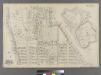
![[Plate 45: Bounded by W. 170th Street, Edgecombe Avenue (Harlem River, High Bridge Park), W. 158th Street, Hudson River (N.Y.C. and H.R.R.R.).]](https://images-2.georeferencer.com/images/iiif/091911648511/full/,300/0/native.jpg)

