Maps of Rauris

Hofgastein.
from Spezialkarte der osterreichisch-ungarischen Monarchie.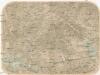
[Bad Gastein und Umgebung]
Bad Gastein (Rakousko) Skrzeszewski, Adolf von
Karte des Sonnblick und Umgebung
1 : 50000 Freytag, Gustav Kartogr. Anstalt G. Freytag & Berndt
Sonnblickkarte des Deutschen Alpenvereins
1 : 25000 Bad Gastein (Rakousko) Noßberger, Adolf Hauptvermessungsabteilung XIV
Karte des Sonnblick und Umgebung
1 : 50000 Freytag, Gustav Deutscher und Österreichischer Alpenverein
Umgebung von Bad Gastein und Panorama vom Gamskahr-Kogl
1 : 6000 Bad Gastein (Rakousko) Souvent, Alois Kolowrat-Liebsteinský, František Antonín
Umgebung von Bad Gastein und Panorama vom Gamskahr-Kogl
1 : 6000 Bad Gastein (Rakousko) Souvent, Alois Kolowrat-Liebsteinský, František Antonín Rudolf Maschek
Umgebung von Bad Gastein und Panorama vom Gamskahr-Kogl
1 : 6000 Bad Gastein (Rakousko) Souvent, Alois Kolowrat-Liebsteinský, František Antonín Rudolf Maschek
Bad Fusch
1 : 25000 Hauptvermessungsabteilung XIV
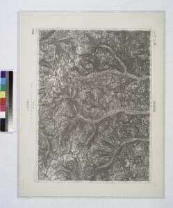
Rauris
1 : 25000 Kartographisches Institut
Kolm Saigurn
1 : 25000 Hauptvermessungsabteilung XIV
Heiligenblut
1 : 25000 Hauptvermessungsabteilung XIV
Winkl Heiligenblut
1 : 25000 Kartographisches Institut
Dorf Fusch
1 : 25000 Kartographisches Institut
Plan des Wildbades Gastein und seiner naechsten Umgebung
Bad Gastein (Rakousko) Dits, Ferdinand Flemming, Carl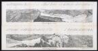
Panorama vom Sonnblick 3090 m in die Rauris
Siegl, Julius Ritter von
Graden Alpe
1 : 25000 Alpy rakouské (pohoří : oblast) Kartographisches Institut
Obervellach
1 : 25000 Ober Vellach (Rakousko) Hauptvermessungsabteilung XIV
Dollach
1 : 25000 Hauptvermessungsabteilung XIV
Oberkolbnitz
1 : 25000 Kartographisches Institut
Stall
1 : 25000 Kartographisches Institut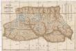
Karte der Hohen Tauern
1 : 144000 Vysoké Taury (Rakousko : pohoří) Sonklar, Karl von Beck'sche Universitäts Buchhandlung
196. Steinernes Meer, uit: Topographische Uebersichtskarte des Deutschen Reiches / herausgegeben v. d. Kartogr. Abt. d. Königl. Preuß. Landesaufnahme
1 : 200000 titelvariant: Topogr. Übersichtskarte des Deutschen Reiches; Annotatie: Titel boven bladen ook: Topogr. Übersichtskarte des Deutschen Reiches; Annotatie geografische gegevens: Op elk blad twee maatstokken: 10 Kilometer = 5,5 cm; 1 geogr. Meile = 3,6 cm; Legenda onder op elk blad Königlich Preußische Landesaufnahme. Kartographische Abtheilung [S.l : Königlich Preußische Landesaufnahme, Kartographische Abtheilung]
Moll Thal.
from Spezialkarte der osterreichisch-ungarischen Monarchie.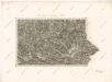
Carte des Herzogthums Salzburg...

Grosz-Glockner.
from Spezialkarte der osterreichisch-ungarischen Monarchie.
St. Michael.
from Spezialkarte der osterreichisch-ungarischen Monarchie.
Karte der Glockner Gruppe
1 : 60000 Grossglockner (Vysoké Taury, Rakousko : hora) Wiedenmann, P. J. Lindauer'sche Buchhandlung
Special-Karte der Gross-Glockner-Gruppe
1 : 50000 Petters, Hugo Deutscher und Oesterreichischer Alpenverein