Maps of Satu Mare

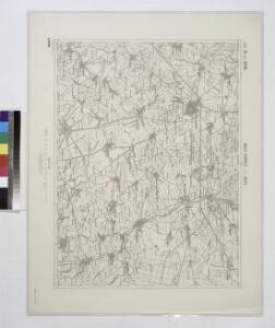
Nagy-Karoly und Akos.; Spezialkarte der osterreichisch-ungarischen Monarchie.
from Spezialkarte der osterreichisch-ungarischen Monarchie. Austro-Hungarian Monarchy. Militärgeographisches Institut.,
15 Zóna, XXVII Rovat, Nagy-Károly és Ákos Vidéke (Umgebungen von Nagy-Károly und Ákos), uit: [Geologische Specialkarte der im Reichsrathe vertretenen Königreiche und Länder der österreichisch-ungarischen Monarchie] / geologische Aufnahmen der königl. ung. Geologischen Anstalt
1 : 75000 Annotatie: Verantwoordelijkheidsvermelding in 1909 veranderd in: Königliche Ungarische Geologische Reichsanstalt; Sommige bladen in het Frans; Annotatie geografische gegevens: Coördinaten gebaseerd op nulmeridiaan van Ferro (Hierro) Königliche Ungarische Geologische Reichsanstalt; Königliche Ungarische Geologische Anstalt Budapest : [Königliche Ungarische Geologische Anstalt]
Lambert-Cholesky sheet 2479 (Careii Mari Sud)
1 : 20000 Romanian military topographic map sheet under Lambert-Cholensky projection Serviciul Geografic al Armatei geo-spatial.org Serviciul Geografic al Armatei
Lambert-Cholesky sheet 2478 (Santău)
1 : 20000 Romanian military topographic map sheet under Lambert-Cholensky projection Serviciul Geografic al Armatei geo-spatial.org Serviciul Geografic al Armatei
Lambert-Cholesky sheet 2579 (Craidarolț)
1 : 20000 Romanian military topographic map sheet under Lambert-Cholensky projection Serviciul Geografic al Armatei geo-spatial.org Serviciul Geografic al Armatei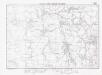
Lambert-Cholesky sheet 2578 (Acaș)
1 : 20000 Romanian military topographic map sheet under Lambert-Cholensky projection Institutul Geografic Militar geo-spatial.org Institutul Geografic Militar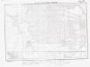
Lambert-Cholesky sheet 2480 (Carei Nord)
1 : 20000 Romanian military topographic map sheet under Lambert-Cholensky projection Institutul Geografic Militar geo-spatial.org Institutul Geografic Militar
Lambert-Cholesky sheet 2580 (Doba)
1 : 20000 Romanian military topographic map sheet under Lambert-Cholensky projection Institutul Geografic Militar geo-spatial.org Institutul Geografic Militar
Lambert-Cholesky sheet 2378 (Pişcolţ)
1 : 20000 Romanian military topographic map sheet under Lambert-Cholensky projection Serviciul Geografic al Armatei geo-spatial.org Serviciul Geografic al Armatei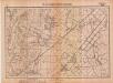
Lambert-Cholesky sheet 2379 (Sanislău)
1 : 20000 Romanian military topographic map sheet under Lambert-Cholensky projection Serviciul Geografic al Armatei geo-spatial.org Serviciul Geografic al Armatei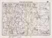
Lambert-Cholesky sheet 2380 (Foen)
1 : 20000 Romanian military topographic map sheet under Lambert-Cholensky projection Serviciul Geografic al Armatei geo-spatial.org Serviciul Geografic al Armatei
Generální mapa ČSR

Szatmár vármegye térképe
1 : 425000 Maďarsko Kogutowicz, Manó Magyar Földrajzi Intézet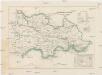
Szathmárer Comitat
1 : 280000 Satu-Mare-oblast (Rumunsko)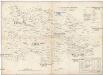
Szathmárer Comitat
1 : 300000 Satu-Mare (Rumunsko : oblast)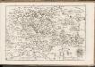
C. Szathmariensis
Rumänien Komitat Sathmar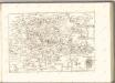

Jank.
from Spezialkarte der osterreichisch-ungarischen Monarchie.
Tasnad und Szeplak.
from Spezialkarte der osterreichisch-ungarischen Monarchie.
Szinyer-Varalja und Kraszna-Beltek.
from Spezialkarte der osterreichisch-ungarischen Monarchie.
Nyir-Beltek und Hajdu-Yamos-Percs.
from Spezialkarte der osterreichisch-ungarischen Monarchie.
Lambert-Cholesky sheet 2577 (Supurul de Jos)
1 : 20000 Romanian military topographic map sheet under Lambert-Cholensky projection Institutul Geografic Militar geo-spatial.org Institutul Geografic Militar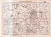
Lambert-Cholesky sheet 2477 (Tăşnad)
1 : 20000 Romanian military topographic map sheet under Lambert-Cholensky projection Serviciul Geografic al Armatei geo-spatial.org Serviciul Geografic al Armatei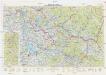
Neubertova generální automapa Republiky československé
1 : 200000 Chust (Ukrajina) Soukup, Jan V. Neubert a synové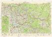
Neubertova generální automapa Republiky československé
1 : 200000 Chust (Ukrajina) Soukup, Jan V. Neubert a synové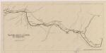
Sbírka map a diagramů použitých na mírových konferencích v Paříži v letech 1919 - 1920
A szlovákok településterülete a szomszédsági mutató alapján Északkelet-Magyarországon 1880-ban
Ungarn (Nordost) Slowaken, Siedlung Bottlik, Zsolt
A szlovákok településterülete a szomszédsági mutató alapján Északkelet-Magyarországon 1980-ban
Ungarn (Nordost) Slowaken, Siedlung Bottlik, Zsolt
A szlovákok településterülete a szomszédsági mutató alapján Északkelet-Magyarországon 1941-ban
Ungarn (Nordost) Slowaken, Siedlung Bottlik, Zsolt