Maps of okres Brno-město

Brno

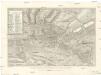
Neuester Situations Plan der köngl. Landeshauptstadt Brünn
Brno (Česko) Fischer, Max Perna, M. Anton Nitsch
Situations-Plan der königlichen Hauptstadt Brünn
1 : 14500 Brno (Česko) Doležal, Franz Fr. Karafiat
Pohonitz (Pohonice) - m0133-1-001 - Kaiserpflichtexemplar der Landkarten des stabilen Katasters
1 : 2880
Pohonitz (Pohonice) - m0133-1-002 - Kaiserpflichtexemplar der Landkarten des stabilen Katasters
1 : 2880
Pohonitz (Pohonice) - m0133-1-003 - Kaiserpflichtexemplar der Landkarten des stabilen Katasters
1 : 2880
Brno

Brno
Aigendliche Abbildung der Schwerren und Harten Belegerung der Stadt Brünn von der Khron Schweden vom 3 May bis auf den 20 Augusti des 1645 Jahrs
Brno (Česko) Pinkawa, Leopold Benno Bayer, Hieronymus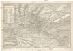
Aigendliche Abbildung der Schwerren und Harten Belegerung der Stadt Brünn von der Khron Schweden vom 3 May bis auf den 20 Augusti des 1645 Jahrs
Brno (Česko) Pinkawa, Leopold Benno Bayer, Hieronymus
Neuester Plan der Landeshauptstadt Brünn

Plán Brna

Brno

Komůrkův plán Brna

Brno
Plán Brna
Brno (Česko) Fischer, Max Perna, M.
Brünn (Brno)

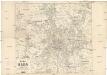
Situation[s]-Plan der königl. Landes-Hauptstadt Brünn
Brno (Česko) Perna, M. C. Winkler's Buchhandlung
Orientační mapy: Brno
Bělohlav, Josef

Brno s okolím
Vojenský zeměpisný ústav
Politický okres brněnský
Vlastivědná sekce učitelstva okresu Brno-venkov
Brno

Eisenbahn Karte Wien-Dresden, Ollmütz-Trübau
1 : 72000 Blatt 5 Minarzik, Anselm J. Rauh
Schlachtenpläne der Napoleonischen Zeit. Austerlitz 2. Dezember 1805
1 : 300000 Austerlitz (Region) Dreikaiserschlacht bei Austerlitz
Státní mapa ČSR

Podrobné mapy zemí Koruny české v měřítku 1:75.000 a mapa vzdáleností všech míst při silnici ležících - Brno. Průvodce statisticko-historický po všech místech na těchto mapách uvedených a rejstřík věcný názvů hor, potoků, řek, rybníků atd. Sešit 5. List 116,
1 : 75000
Podrobné mapy zemí Koruny české v měřítku 1:75.000 a mapa vzdáleností všech míst při silnici ležících
1 : 75000 Brno (Česko : oblast) Bělohlav, Josef F. Topič
Podrobné mapy zemí Koruny české v měřítku 1:75.000 a mapa vzdáleností všech míst při silnici ležících - Brno. Průvodce statisticko-historický po všech místech na těchto mapách uvedených a rejstřík věcný názvů hor, potoků, řek, rybníků atd. Sešit 5. List 116,
1 : 75000


