Maps of Smíchov

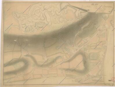
Plan der südlichen Seite des Laurentyberges bey Prag
Polohopisný plán královského hlavního města Prahy : 1.Staré město, 2.Nové město, 3.Malá strana, 4.Hradčany, 5.Josefov, 6.Vyšehrad pak Smíchova, Karlína, král.Vinohradů, Žižkova a Nuslí, s udáním starých i nových čísel domů
1 : 4000
Hlavní město Praha...

Původní (částečně změněný) návrh obce Pražské
1 : 1400 Smíchov (Praha, Česko) nákl. obce Pražské
Plán královského hlavního města Prahy 1815

Orientační plán Prahy a obcí sousedních List 15.
1 : 5000
Polohopisný plán Smíchova a Košíř
1 : 4000
Praha : orientační plán : Československá spartakiáda 1975
1 : 15000
Obci [sic] Smíchovskou navržené upravení hranic
1 : 1400 Smíchov (Praha, Česko) nákl. obce Pražské
Situations-Plan litt A. über den k. k. botanischen Garten am Smichov bei Prag sam[m]t allen darin befindlichen Gebauden
1 : 535 Smíchov (Praha, Česko)
Situationsplan des k. k. botanischen Gartens in Smichow
1 : 720 Smíchov (Praha, Česko)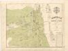
Polohopisný plán Smíchova a Košířů

Orientační plán král. Hl. města Prahy

Grundrisz der königlichen Hauptstadt Prag
Praha (Česko) Jüttner, Josef Drda, Josef Jan Alois auf Veranlassung und Kosten des böhmischen Nationalmuseums
Plán hlavního města království českého Praha

Polohopisný plán Prahy
Praha (Česko) K. Hübner
Situations Plan der Gegend vor dem Augezder Thore zum Gebrauche bei der Beurtheilung der Distanzen
1 : 12600 Praha (Česko) Situations-Zeichnungs-Schule des k. k. G.F.M.L. Graf Kunigl 1.ten Feld-Artill. Regiments Schwihlik, Franz Situations-Zeichnungs-Schule des k. k. G.F.M.L. Graf Kunigl 1.ten Feld-Artill. Regiments
Grund-Rieß uber den Kossirz- und Czibulker Hoff auch Czisarzska
1 : 2500 Košíře (Praha, Česko) Mann, Johann Joseph Florian
Praha, hlavní město ČSR : Fastrův obrázkový plán a průvodce
1 : 10000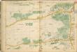
Auto-Praha : automobilní plán Velké Prahy a příručka pro automobilisty
1 : 50000
Praha. Mapy staré Prahy k letům 1200, 1348 a 1419

Smíchov : předměstí král. hlavního města Prahy

Smíchov

Grundriss von Prag, nach den besten Hülfsmitteln dargestellt
1 : 125000 gestochen von W. Schuldes Prag : J. G. Calve'sche Buchhandlung
Prag - c6068-1-002 - Kaiserpflichtexemplar der Landkarten des stabilen Katasters
1 : 2880
Prag - c6068-1-006 - Kaiserpflichtexemplar der Landkarten des stabilen Katasters
1 : 2880
Prag - c6068-1-003 - Kaiserpflichtexemplar der Landkarten des stabilen Katasters
1 : 2880
Prag - c6068-1-001 - Kaiserpflichtexemplar der Landkarten des stabilen Katasters
1 : 2880
Prag - c6068-1-004 - Kaiserpflichtexemplar der Landkarten des stabilen Katasters
1 : 2880