Maps of okres Louny
Mappa geographica regni Bohemiae in duodecim circulos divisae ...
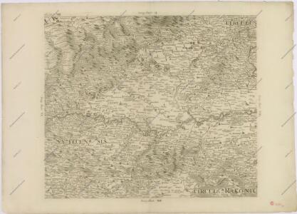
Müllerova mapa Čech
1 : 132000
Monumenta Cartographica Bohemiae II.: Müllerova mapa

Karte des Saazer Kreises im Königreiche Böhmen
1 : 145000 Žatec-oblast (Louny, Česko) Wostrý, Karl Malik. Aug. Ferdinand Ritter
Die Verschiebung der nationalen Schichtung der Bevölkerung in Nordwest-Böhmen von 1880 bis 1930
Čechy severozápadní (Česko) Deutscher Kulturverband
Beckerova přehledná mapa severozápadní české pánve hnědouhelné

Charte vom Saazer Kreis im Königreiche Böhmen
Žatec-oblast (Louny, Česko) Berghaus, Heinrich Karl Wilhelm Kutschera, E. E. Kutschera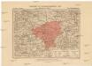
Generalkarte der Bezirkshauptmannschaft Saaz
1 : 220000 Žatec-oblast (Louny, Česko) Wagner, Jan Eduard F. Kytka
Karte des Saazer Hopfenbaugebietes
1 : 114000 Žatec (Louny, Česko : oblast) Bauer, Ambros J. Kern
Generalkarte der Bezirkshauptmannschaft Komotau
1 : 220000 Chomutov-oblast (Česko) Wagner, Jan Eduard F. Kytka
Generalkarte der Bezirkshauptmannschaft Komotau
1 : 220000 Chomutov-oblast (Česko) Wagner, Jan Eduard F. Kytka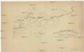
Geologische Uibersichtskarte von Karlsbad bis Bauschowitz
Bohušovice nad Ohří (Česko)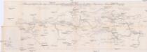
Becker's Übersichtskarte des nordwestböhmischen Braunkohlen-Reviers Kaaden-Aussig
1 : 75000 Kadaň (Česko : oblast) Becker, Adolf Parma, Alois Adolf Becker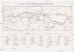
Uebersichtskarte des Nordwestböhmischen Braunkohlenbeckens
1 : 144000 Chomutov (Česko : oblast) Adolf Becker
Saaz und Komotau.
from Spezialkarte der osterreichisch-ungarischen Monarchie.
Mapa chmelařského obvodu žateckého
Žatec-oblast (Louny, Česko) Mohl, Antonín
Umgebungen von Kommotau und Saaz
1 : 750000 Chomutov (Česko : oblast) K. k. militär-geographisches Institut
Les Tchécoslovaques et les Allemands au nord-ouest de la Boheme
Čechy severní (Česko) Vojenský zeměpisný ústav
Župa lounská
1 : 100000 Louny-oblast (Česko) Nový, Karel Edv. Fastr
III. vojenské mapování 3851
1 : 75000
Podrobná mapa Království českého
1 : 100000 Chomutov (Česko : oblast) Srp, Jan Jaroslav Bursík
Národnostní mapa severozápadních Čech

Vilímkovy místopisné mapy zemí Koruny české
1 : 100000 Chomutov (Česko : oblast) Srp, Jan Jos. R. Vilímek
Most a okolí
1 : 75000 Most (Česko : oblast) Vojenský zeměpisný ústav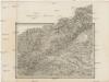
Umgebungen von Kommotau und Saaz
Chomutov-oblast (Česko) Gargani, Ludwig K. u. k. Militärgeographisches Institut
II. vojenské mapování 6
1 : 144000
České středohoří a Krušnohoří
1 : 100000 Krušné hory-oblast (Česko a Německo) Edv. Fastr
Geologische & Gruben-Revier-Karte des Nordwestböhmischen Braunkohlenbeckens
1 : 75000 Most-oblast (Česko) Fest, F. vom vereinigten Brüx-Dux-Oberleutensdorfer Berg-Revier
Geologische & Gruben-Revier-Karte des Nordwestböhmischen Braunkohlenbeckens
1 : 75000 Most-oblast (Česko) Fest, F. vom vereinigten Brüx-Dux-Oberleutensdorfer Berg-Revier