Maps of Letňany
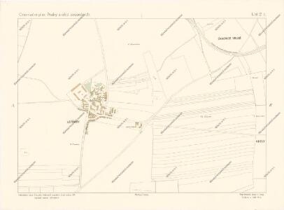
Orientační plán Prahy a obcí sousedních List 2c.

Lettnian - c3894-1-004 - Kaiserpflichtexemplar der Landkarten des stabilen Katasters
1 : 2880
Lettnian - c3894-1-001 - Kaiserpflichtexemplar der Landkarten des stabilen Katasters
1 : 2880
Lettnian - c3894-1-003 - Kaiserpflichtexemplar der Landkarten des stabilen Katasters
1 : 2880
Lettnian - c3894-1-002 - Kaiserpflichtexemplar der Landkarten des stabilen Katasters
1 : 2880
[Vojenské postavení mezi Prosekem a Kbely]
Kbely (Praha, Česko)
Czakowitz - c0787-1-003 - Kaiserpflichtexemplar der Landkarten des stabilen Katasters
1 : 2880
Czakowitz - c0787-1-002 - Kaiserpflichtexemplar der Landkarten des stabilen Katasters
1 : 2880
Czakowitz - c0787-1-001 - Kaiserpflichtexemplar der Landkarten des stabilen Katasters
1 : 2880
Gbell - c3083-1-002 - Kaiserpflichtexemplar der Landkarten des stabilen Katasters
1 : 2880
Gbell - c3083-1-001 - Kaiserpflichtexemplar der Landkarten des stabilen Katasters
1 : 2880
Gbell - c3083-1-003 - Kaiserpflichtexemplar der Landkarten des stabilen Katasters
1 : 2880
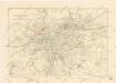
Orientační plán hlavního města Prahy s okolím
1 : 5000
Orientační plán hlavního města Prahy s okolím

Orientační plán hlavního města Prahy s okolím
1 : 5000
Situations-Plan des Reservat Jagel Terrains bey Prag gegen Chwala so weil dieses von gegenwärtigen Herrn Kommandirenden auf 6 Jahre gepachtet worden ist
1 : 15000 Trampusek, Franz Le Roy
Orientierungsplan der Hauptstadt Prag
Jiřík, Rudolf
Projectierte Lager
1 : 15000 Brandýs nad Labem (Česko)
Výškopisný plán hlavního města Prahy s okolím

Výškopisný plán hlavního města Prahy s okolím
Les environs de Prague
1 : 31000 Praha (Česko)
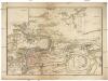
Plan de la Bataille... le 6 May 1757

Přehledná mapa Velké Prahy : [s průvodcem a popisem všech obcí v ní zahrnutých] : [odpolední výlety po okolí pražském]
1 : 34725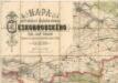
Mapa politického a školního okresu Českobrodského
Plán sběrného okruhu a dopravních spojů pro motorová vozidla

III. vojenské mapování 3953/1
1 : 25000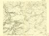
III. vojenské mapování 3953/1
1 : 25000
[Praha a okolí]
Praha-oblast (Česko)
Gradkartenblatt
1 : 25000 Čechy (Česko) Czechák, Carl
[Praha - projekt podzemní a nadzemní dráhy].
Praha (Česko) Poláček, K. Wallenfels, F.