Maps of Czech Republic

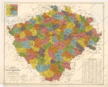
Nejnovější příruční mapa Království Českého

Historische Karte vom Königreich Böhmen
Čechy (Česko) Pařízek, Aleš Vincenc Niederhofer, Ondřej
Historische Karte vom Königreich Böhmen
Česko Pařízek, Aleš Vincenc Niederhofer, Ondřej
Generální mappa království Českého

Politická a místopisná mapa Království českého
1 : 418000 Česko Erben, Josef nákladem kněhkupectví K. Janského
Politická a místopisná mapa Království českého
1 : 418000 Česko Erben, Josef Smolík, Ott. nákladem kněhkupectví K. Janského
Politická a místopisná mapa Království českého
1 : 418000 Česko Erben, Josef Smolík, Ott. nákladem kněhkupectví K. Janského
General-Uibersichts-Karte des Königreiches Böhmen
1 : 575000 Česko Windisch-Graetz, Alfred Kandidus C. Hennig u. F. Tempsky
General-Uibersichts-Karte des Königreiches Böhmen
1 : 575000 Česko Windisch-Graetz, Alfred Kandidus C. Hennig u. F. Tempsky
Strassen-Uebersichtskarte von Böhmen
1 : 665000 Česko
Strassen-Uebersichtskarte von Böhmen
1 : 665000 Česko
General-Post & Strassen Karte des Königreichs Boehmen
1 : 642000 Čechy (Česko) Fried, Franz Artaria
Karten zur Statistik des Königreiches Böhmen...

Neueste General Post & Strassen Karte des Königreichs Boehmen

Karte des landtäflichen Grossgrund - Besitzes im Königreiche... Böhmen

Neueste Reisekarte von Böhmen
1 : 600000 Česko Wagner, Jan Eduard F. Kytka
Statistisch topographische Karte des Kronlandes Boehmen
1 : 800000 Německo Steingruber, Konrad Riedl, Johann Baptist Joh. Stiasny
Böhmen
1 : 1000000 Česko Mrvik, J. Paul Sollors' Nachf.
Geologische Karte von Böhmen

Karte des Königreiches Böhmen
1 : 438000 Česko Steinhauser, Anton Mück, Anton Artaria
Neueste General Post & Strassen Karte des Königreichs Boehmen
Čechy (Česko)
Geologische Uebersichtskarte von Böhmen
1 : 720000 Čechy (Česko) Katzer, Friedrich Isak Taussig
Rozdělení okresů školních v Království českém

Národnostní mapa Království Českého na základě sčítání lidu z roku 1880

Bez titulu: Soubor statistických map Čech

Skelett für die Special-Karte des Königreich's Böhmen
Česko K. u. k. Militärgeographisches Institut
Strassen-Uibersichts- und Militair-Routen-Karte des Königreichs Böhmen
1 : 580400 Česko Berra, Marco Marco Berra
Strassen-Uibersichts- und Militair-Routen-Karte des Königreichs Böhmen
1 : 580400 Česko Berra, Marco Marco Berra
Strassen-Uibersichts- und Militair-Routen-Karte des Königreichs Böhmen
1 : 580400 Česko Windisch-Graetz, Alfred Kandidus Joh. Evang. G. Sandtner
Strassen-Uibersichts- und Militair-Routen-Karte des Königreichs Böhmen
1 : 580400 Česko Berra, Marco Marco Berra