Maps of South Gloucestershire

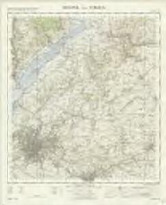
Bristol and Stroud - OS One-Inch Map
1 : 63360 Topographic maps Ordnance Survey Ordnance Survey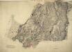
Chipping Sodbury
1 : 31680 The Avon barracks and battery are documented at the mouth of the River Severn, at the top of the map, protecting the Bristol Channel. Gravemounds ('Tumuli'), hill forts, ancient camps and antiquities are distinguished by the use of gothic lettering. The recording of archaeological details became obligatory in 1816. Quarries, kilns, mills, brickyards and pits dominate this industrial region of the West Midlands. According to a note in the Ordnance Survey Day Books, held in the National Archives, a one inch-to-the-mile reduction of this plan was delivered to Captain Gossett for engraving in the Drawing Office at the Tower of London in March 1830. Crocker, Edmund
Chepstow
1 : 31680 Thomas Budgen surveyed the majority of the Welsh plans, and is probably author of this drawing of the Severn Estuary. The plan is a good example of the use of black and red ink to distinguish between wooden and masonry structures. Chepstow Bridge, on the River Wye, is illustrated with red piers and a black roadway. Budgen, Thomas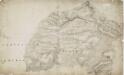
Malmesbury
1 : 31680 This drawing covers the counties of Gloucestershire and Wiltshire, with their boundary indicated by a pecked line. The Wiltshire and Berkshire Canal is shown. Individual locks are indicated by breaks in the blue watercolour line. The Roman road from Bath to Cirencester is marked, and "Ancient Entrenchments" are noted nearby, represented by tiny outline plans of their structure. Crocker, Edmund
Stroud
The stunning landscapes in this part of the Costwolds is captured by the skillful and artistic use of hachures, lines and color to indicate slope and landcover on the map. Crocker, E.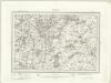
Malmesbury (Outline) - OS One-Inch Revised New Series
1 : 63360 Topographic maps Ordnance Survey Ordnance Survey
Malmesbury (Hills) - OS One-Inch Revised New Series
1 : 63360 Topographic maps Ordnance Survey Ordnance Survey
Bath (Hills) - OS One-Inch Revised New Series
1 : 63360 Topographic maps Ordnance Survey Ordnance Survey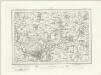
Bath (Outline) - OS One-Inch Revised New Series
1 : 63360 Topographic maps Ordnance Survey Ordnance Survey
Bristol 9
1 : 31680 This hill sketch features an engraved outline reading 'Ordnance map of the environs of Bristol'. Military barracks and batteries protecting the Bristol Cannel are recorded at the mouth of the River Severn, at the top of the map. Grave mounds ('Tumuli'), hillforts, ancient camps and antiquities are noted in gothic script at Bitton and to the right of Dundry Hill. Otherwise, quarries, mills and pits dominate this industrial region of the county of Avon. Corrections in red ink and other additions were made at a later date. Dawson, Robert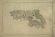
Bath 1
Bath is the main settlement in this drawing, appearing in the bottom right-hand corner. The city's Georgian street plan is shown in red. Near the middle of the city, a circular shape represent the Circus, a superb piazza built between 1754 and 1770 by John Wood, father and son. Two curvilinear shapes nearby represent Lansdown Crescent (built 1789-93 by John Palmer) and the Royal Crescent (built 1767-75 by John Wood, the younger). These architectural developments were relatively new when the drawing was made. They remain the finest of their types in the country. Just outside Bath is Lansdown, with a Roman route marked "roman Vicinal Way". An "Ancient Camp" and an "Ancient Intrenchment" are also indicated - evidence that Bath had been a settlement since the Roman era, its prosperity founded on its mineral springs. The status of the drawing as a finished copy is affirmed by the ink border and italic lettering. Crocker, Edmund
Gloucester (Hills) - OS One-Inch Revised New Series
1 : 63360 Topographic maps Ordnance Survey Ordnance Survey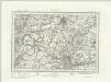
Gloucester (Outline) - OS One-Inch Revised New Series
1 : 63360 Topographic maps Ordnance Survey Ordnance Survey
Chepstow (Hills) - OS One-Inch Revised New Series
1 : 63360 Topographic maps Ordnance Survey Ordnance Survey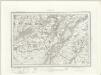
Chepstow (Outline) - OS One-Inch Revised New Series
1 : 63360 Topographic maps Ordnance Survey Ordnance Survey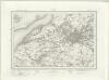
Bristol (Outline) - OS One-Inch Revised New Series
1 : 63360 Topographic maps Ordnance Survey Ordnance Survey
Bristol (Hills) - OS One-Inch Revised New Series
1 : 63360 Topographic maps Ordnance Survey Ordnance Survey
SO50 - OS 1:25,000 Provisional Series Map
1 : 25000 Topographic maps Ordnance Survey Ordnance Survey
ST59 - OS 1:25,000 Provisional Series Map
1 : 25000 Topographic maps Ordnance Survey Ordnance Survey
ST58 - OS 1:25,000 Provisional Series Map
1 : 25000 Topographic maps Ordnance Survey Ordnance Survey
SO60 - OS 1:25,000 Provisional Series Map
1 : 25000 Topographic maps Ordnance Survey Ordnance Survey
ST57 - OS 1:25,000 Provisional Series Map
1 : 25000 Topographic maps Ordnance Survey Ordnance Survey
ST69 - OS 1:25,000 Provisional Series Map
1 : 25000 Topographic maps Ordnance Survey Ordnance Survey
ST56 - OS 1:25,000 Provisional Series Map
1 : 25000 Topographic maps Ordnance Survey Ordnance Survey
ST68 - OS 1:25,000 Provisional Series Map
1 : 25000 Topographic maps Ordnance Survey Ordnance Survey
SO70 - OS 1:25,000 Provisional Series Map
1 : 25000 Topographic maps Ordnance Survey Ordnance Survey
ST67 - OS 1:25,000 Provisional Series Map
1 : 25000 Topographic maps Ordnance Survey Ordnance Survey
ST79 - OS 1:25,000 Provisional Series Map
1 : 25000 Topographic maps Ordnance Survey Ordnance Survey
ST66 - OS 1:25,000 Provisional Series Map
1 : 25000 Topographic maps Ordnance Survey Ordnance Survey