Maps of Carmarthenshire

Carnarthen And Tenby - OS One-Inch Map
1 : 63360 Topographic maps Ordnance Survey Ordnance Survey
Carmarthen (Outline) - OS One-Inch Revised New Series
1 : 63360 Topographic maps Ordnance Survey Ordnance Survey
Carmarthen (Hills) - OS One-Inch Revised New Series
1 : 63360 Topographic maps Ordnance Survey Ordnance Survey
Worms Head (Hills) - OS One-Inch Revised New Series
1 : 63360 Topographic maps Ordnance Survey Ordnance Survey
Worms Head (Outline) - OS One-Inch Revised New Series
1 : 63360 Topographic maps Ordnance Survey Ordnance Survey
Carmarthen(002OSD000000010U00137000)
1 : 31680 This plan comprises two sheets joined together, depicting Carmarthen Bay on the Bristol Channel and the upper tidal reaches of the River Towy. The irregularly shaped paper is so worn that much of the detail is now erased. Sand dunes and marshland dominate the landscape of the Cefn Sidan Sands at the bottom of the chart and a faded aquamarine wash remains visible on the Rivers Taf and Towy. Budgen, Thomas
Carmarthen(002OSD000000010U00136000)
1 : 31680 Sand dunes and marshland dominate the landscape of Carmarthen Bay on the Bristol Channel at the bottom of this chart. The map is drawn on three sheets pieced together with detail extending over the joins. Place names are difficult to read where the drawing is ripped and worn, but the path of the River Taff is clearly plotted from centre left of the map, crossing the county until it reaches the sea at Laugharne. Archaeological details are documented even though this did not become obligatory until 1816. Budgen, Thomas
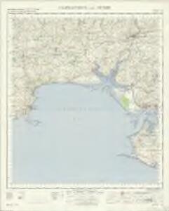
Tenby
1 : 31680 This plan of the Pembrokeshire coast shows the deep-sea port of Tenby at lower right and the River Cleddau Valley, with its broad tidal estuary flowing into Milford Haven, at lower left. Tidal rivers, called 'pills' on this plan, are a peculiar feature of the south Pembrokeshire landscape. Along the banks of one of the pills is the small settlement of Carew with the remains of an 11th-century castle and tidal mill indicated. Budgen, Thomas
Pembroke (Hills) - OS One-Inch Revised New Series
1 : 63360 Topographic maps Ordnance Survey Ordnance Survey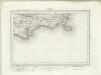
Pembroke (Outline) - OS One-Inch Revised New Series
1 : 63360 Topographic maps Ordnance Survey Ordnance Survey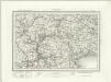
Haverfordwest (Outline) - OS One-Inch Revised New Series
1 : 63360 Topographic maps Ordnance Survey Ordnance Survey
Haverfordwest (Hills) - OS One-Inch Revised New Series
1 : 63360 Topographic maps Ordnance Survey Ordnance Survey
SN12 - OS 1:25,000 Provisional Series Map
1 : 25000 Topographic maps Ordnance Survey Ordnance Survey
SN11 - OS 1:25,000 Provisional Series Map
1 : 25000 Topographic maps Ordnance Survey Ordnance Survey
SN22 - OS 1:25,000 Provisional Series Map
1 : 25000 Topographic maps Ordnance Survey Ordnance Survey
SN10 - OS 1:25,000 Provisional Series Map
1 : 25000 Topographic maps Ordnance Survey Ordnance Survey
SN21 - OS 1:25,000 Provisional Series Map
1 : 25000 Topographic maps Ordnance Survey Ordnance Survey
SS19 - OS 1:25,000 Provisional Series Map
1 : 25000 Topographic maps Ordnance Survey Ordnance Survey
SN32 - OS 1:25,000 Provisional Series Map
1 : 25000 Topographic maps Ordnance Survey Ordnance Survey
SN20 - OS 1:25,000 Provisional Series Map
1 : 25000 Topographic maps Ordnance Survey Ordnance Survey
SN31 - OS 1:25,000 Provisional Series Map
1 : 25000 Topographic maps Ordnance Survey Ordnance Survey
SN30 - OS 1:25,000 Provisional Series Map
1 : 25000 Topographic maps Ordnance Survey Ordnance Survey
SS49 & Parts of SS39 - OS 1:25,000 Provisional Series Map
1 : 25000 Topographic maps Ordnance Survey Ordnance Survey
SN41 - OS 1:25,000 Provisional Series Map
1 : 25000 Topographic maps Ordnance Survey Ordnance Survey
SS48 & Parts of SS38 - OS 1:25,000 Provisional Series Map
1 : 25000 Topographic maps Ordnance Survey Ordnance Survey
SN40 - OS 1:25,000 Provisional Series Map
1 : 25000 Topographic maps Ordnance Survey Ordnance Survey
SN42 - OS 1:25,000 Provisional Series Map
1 : 25000 Topographic maps Ordnance Survey Ordnance Survey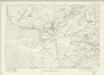
Carmarthenshire LIII - OS Six-Inch Map
1 : 10560 Topographic maps Ordnance Survey Ordnance Survey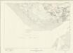
Carmarthenshire LVII - OS Six-Inch Map
1 : 10560 Topographic maps Ordnance Survey Ordnance Survey