Maps of Aberdeenshire
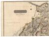
Northern Part of Aberdeen & Banff Shires.
Thomson, John, 1777- ca. 1840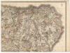
Northern Part of Aberdeen & Banff Shires.
Thomson, John, 1777- ca. 1840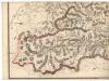
Southern Part of Aberdeen & Banff Shires.
Thomson, John, 1777- ca. 1840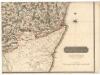
Southern Part of Aberdeen & Banff Shires.
Thomson, John, 1777- ca. 1840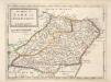
The Shires of Bamf [i.e. Banff] and Aberdeen / by H. Moll.
Moll, Herman, d. 1732
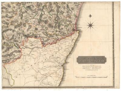
Topographical and military map of the counties of Aberdeen, Banff and Kincardine.
Robertson, James, fl. 1810-1829
Topographical and military map of the counties of Aberdeen, Banff and Kincardine.
Robertson, James, fl. 1810-1829
Topographical and military map of the counties of Aberdeen, Banff and Kincardine.
Robertson, James, fl. 1810-1829
Topographical and military map of the counties of Aberdeen, Banff and Kincardine.
Robertson, James, fl. 1810-1829
Topographical and military map of the counties of Aberdeen, Banff and Kincardine.
Robertson, James, fl. 1810-1829
Topographical and military map of the counties of Aberdeen, Banff and Kincardine.
Robertson, James, fl. 1810-1829
Dvo vicecomitatvs Aberdonia [et] Banfia
1 Karte : Kupferdruck ; 41 x 54 cm Blaeu; Gordon Joan Blaeu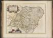
Duo Vicecomitatus Aberdonia & Banfia, una cum Regionibus & terrarum tractibus sub iis comprehensis / Auctore Roberto Gordonio à Straloch. Description of the two Shyres Aberdene and Banf,
Gordon, Robert, 1580-1661 Blaeu, Joan, 1596-1673
Composite: Aberdeen, Banff S.
1 : 95000 Thomson, John
DVO VICECOMITATVS | ABERDONIA & BANFIA, | Una cum Regionibus & terrarum tractibus | sub iis comprehensis. [=] A Description of the two Shyres | ABERDENE and BANF, | With such Countreys and Provinces as ar | comprehended under them.
Auctore Roberto Gordonio à Straloch. [Amsterdam : Joan Blaeu]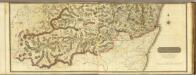
Composite: South Aberdeen, Banff S.
1 : 95000 Thomson, John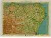
Buchan & Strathbogie, Sheet 22 - Bartholomew's "Half Inch to the Mile Maps" of Scotland
1 : 126720 Topographic maps John Bartholomew & Son, Ltd John Bartholomew & Son, Ltd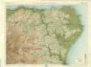
Peterhead & Banff, Sheet 22 - Bartholomew's "Half Inch to the Mile Maps" of Scotland
1 : 126720 Topographic maps Bartholomew, John George John Bartholomew & Co
Composite: Aberdeen, Banff N.
1 : 95000 Thomson, John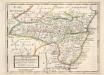
The Shire of Kincairden or Mears with the South Part of Aberdeen Shire &c. / H. Moll.
Moll, Herman, d. 1732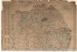
Map of the north eastern districts of Aberdeenshire.
Gibb, Alexander, 1804-1867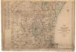
Map of the north eastern districts of Aberdeenshire.
Gibb, Alexander, 1804-1867
Aberdeen - Bartholomew's 'Survey Atlas of Scotland'
1 : 126720 Topographic maps John Bartholomew & Son, Ltd John Bartholomew & Son, Ltd
Balmoral - Bartholomew's 'Survey Atlas of Scotland'
1 : 126720 Topographic maps John Bartholomew & Son, Ltd John Bartholomew & Son, Ltd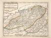
The Shires of Murray and Nairn / by H. Moll.
Moll, Herman, d. 1732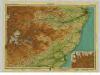
Deeside, Sheet 17 - Bartholomew's "Half Inch to the Mile Maps" of Scotland
1 : 126720 Topographic maps John Bartholomew & Son, Ltd John Bartholomew & Son, Ltd
Aberdeen & Deeside, Sheet 17 - Bartholomew's "Half Inch to the Mile Maps" of Scotland
1 : 126720 Topographic maps Bartholomew, John George John Bartholomew & Co
Nairn, Elgin.
1 : 129000 Johnson, William, fl. 1806-1840
Strathdon - OS One-Inch Map
1 : 63360 Topographic maps Ordnance Survey Ordnance Survey