Maps of Northumberland

Northumberland (New Series) XV.14 (includes: Greys Forest; Hethpool; Kirknewton) - 25 Inch Map
1 : 2500 Topographic maps Ordnance Survey Ordnance Survey
Northumberland (Old Series) XIX.5 (includes: Greys Forest; Hethpool; Kirknewton) - 25 Inch Map
1 : 2500 Topographic maps Ordnance Survey Ordnance Survey
Northumberland (Old Series) XIX.9 (includes: Greys Forest; Kirknewton; Selbys Forest) - 25 Inch Map
1 : 2500 Topographic maps Ordnance Survey Ordnance Survey
Northumberland XIX - OS Six-Inch Map
1 : 10560 Topographic maps Ordnance Survey Ordnance Survey
Roxburghshire, Sheet XVII (with inset of sheet XI) - OS 6 Inch map
1 : 10560 Topographic maps Ordnance Survey Ordnance Survey
Northumberland nXV - OS Six-Inch Map
1 : 10560 Topographic maps Ordnance Survey Ordnance Survey
Northumberland XIX.NW - OS Six-Inch Map
1 : 10560 Topographic maps Ordnance Survey Ordnance Survey
Northumberland XIX.SW - OS Six-Inch Map
1 : 10560 Topographic maps Ordnance Survey Ordnance Survey
Ford (Hills) - OS One-Inch Revised New Series
1 : 63360 Topographic maps Ordnance Survey Ordnance Survey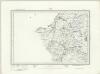
Ford (Outline) - OS One-Inch Revised New Series
1 : 63360 Topographic maps Ordnance Survey Ordnance Survey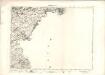
Berwick Upon Tweed - OS One-Inch map
1 : 63360 Topographic maps Ordnance Survey Ordnance Survey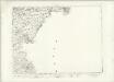
Berwick Upon Tweed - OS One-Inch map
1 : 63360 Topographic maps Ordnance Survey Ordnance Survey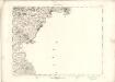
Berwick Upon Tweed - OS One-Inch map
1 : 63360 Topographic maps Ordnance Survey Ordnance Survey
Kelso & The Cheviot (81) - OS One-Inch map
1 : 63360 Topographic maps Ordnance Survey Ordnance Survey
Kelso & The Cheviot (81) - OS One-Inch map
1 : 63360 Topographic maps Ordnance Survey Ordnance Survey
Alnwick - OS One-Inch Map
1 : 63360 Topographic maps Ordnance Survey Ordnance Survey
Berwick Upon Tweed - OS One-Inch Map
1 : 63360 Topographic maps Ordnance Survey Ordnance Survey
Jedburgh - OS One-Inch Map
1 : 63360 Topographic maps Ordnance Survey Ordnance Survey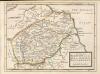
The Shire of Berwick alias the Mers or March and Lauderdale / by H. Moll.
Moll, Herman, d. 1732
Berwick - Bartholomew's 'Survey Atlas of Scotland'
1 : 126720 Topographic maps John Bartholomew & Son, Ltd John Bartholomew & Son, Ltd
THE MERCE | or Shirrefdome of | BERWICK. [=] MERCIA | Vulgo | VICECOMITATVS BERVICENSIS
Auct Timothei Pont [Amsterdam : Joan Blaeu]
TEVIOTIA | Vulgo | TIVEDAIL
[Amsterdam : Joan Blaeu]
Northumberland, North, Sheet 1 - Bartholomew's "Half Inch to the Mile Maps" of England & Wales
1 : 126720 Topographic maps Bartholomew, John George John Bartholomew & Co
Sheets 68-69. (Cary's England, Wales, and Scotland).
1 : 360000 Cary, John, ca. 1754-1835
A new improved map of Northumberland
1 Karte : Kupferdruck ; 67 x 50 cm Kitchin; Hinton sold by J. Hinton at the Kings Arms in St. Pauls Church Yard
Comitatvs Northvmbria; vernacula Northvmberland
1 Karte : Kupferdruck ; 39 x 48 cm Blaeu Joan Blaeu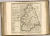

Holy-Island, Fairn Islands with the many Rocks and Hazards that lye Scatter'd in that Sea, and the Coast from Sunderland point in England to St Abbs-head in Scotland, survey'd and navigated by J[oh]n
Adair, John, ca. 1650-1722
COMITATVS | NORTHVMBRIA; | Vernacule | NORTHUMBERLAND.
Ioh. Blaeu Exc.


