Maps of Huntingdonshire
Bedfordshire IX.NW - OS Six-Inch Map
1 : 10560 Topographic maps Ordnance Survey Ordnance Survey
Bedfordshire IX.NW - OS Six-Inch Map
1 : 10560 Topographic maps Ordnance Survey Ordnance Survey
Bedfordshire IX.NW - OS Six-Inch Map
1 : 10560 Topographic maps Ordnance Survey Ordnance Survey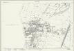
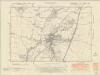
Huntingdonshire XXV.11 (includes: Eaton Socon; Eynesbury; St Neots Rural; St Neots) - 25 Inch Map
1 : 2500 Topographic maps Ordnance Survey Ordnance Survey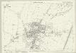
Huntingdonshire XXV.11 (includes: Eaton Socon; Eynesbury; St Neots Rural; St Neots) - 25 Inch Map
1 : 2500 Topographic maps Ordnance Survey Ordnance Survey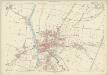
Huntingdonshire XXV.11 (includes: Eaton Socon; Eynesbury; St Neots Rural; St Neots) - 25 Inch Map
1 : 2500 Topographic maps Ordnance Survey Ordnance Survey
Bedfordshire IX.1 (includes: Eaton Socon; Hail Weston; Little Paxton; St Neots) - 25 Inch Map
1 : 2500 Topographic maps Ordnance Survey Ordnance Survey
Bedfordshire IX.5 (includes: Eaton Socon; Eynesbury; St Neots) - 25 Inch Map
1 : 2500 Topographic maps Ordnance Survey Ordnance Survey
Bedfordshire IX.5 (includes: Eaton Socon; Eynesbury; St Neots) - 25 Inch Map
1 : 2500 Topographic maps Ordnance Survey Ordnance Survey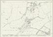
Huntingdonshire XXV.7 (includes: Eaton Socon; Great Paxton; Hail Weston; Little Paxton; St Neots) - 25 Inch Map
1 : 2500 Topographic maps Ordnance Survey Ordnance Survey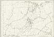
Huntingdonshire XXV.7 (includes: Eaton Socon; Great Paxton; Hail Weston; Little Paxton; St Neots) - 25 Inch Map
1 : 2500 Topographic maps Ordnance Survey Ordnance Survey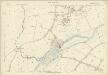
Huntingdonshire XXV.7 (includes: Eaton Socon; Great Paxton; Hail Weston; Little Paxton; St Neots) - 25 Inch Map
1 : 2500 Topographic maps Ordnance Survey Ordnance Survey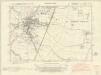
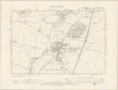
Huntingdonshire XXV.SE - OS Six-Inch Map
1 : 10560 Topographic maps Ordnance Survey Ordnance Survey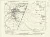
Huntingdonshire XXV.SE - OS Six-Inch Map
1 : 10560 Topographic maps Ordnance Survey Ordnance Survey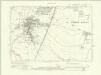
Huntingdonshire XXV.SE - OS Six-Inch Map
1 : 10560 Topographic maps Ordnance Survey Ordnance Survey
Huntingdonshire XXV.SE - OS Six-Inch Map
1 : 10560 Topographic maps Ordnance Survey Ordnance Survey
Huntingdonshire XXV.SE - OS Six-Inch Map
1 : 10560 Topographic maps Ordnance Survey Ordnance Survey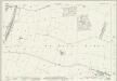
Huntingdonshire XXV.12 (includes: St Neots Rural; St Neots) - 25 Inch Map
1 : 2500 Topographic maps Ordnance Survey Ordnance Survey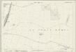
Huntingdonshire XXV.12 (includes: St Neots Rural; St Neots) - 25 Inch Map
1 : 2500 Topographic maps Ordnance Survey Ordnance Survey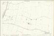
Huntingdonshire XXV.12 (includes: St Neots Rural; St Neots) - 25 Inch Map
1 : 2500 Topographic maps Ordnance Survey Ordnance Survey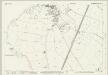
Huntingdonshire XXV.15 (includes: Eaton Socon; Eynesbury Hardwicke; Eynesbury; St Neots Rural; St Neots) - 25 Inch Map
1 : 2500 Topographic maps Ordnance Survey Ordnance Survey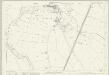
Huntingdonshire XXV.15 (includes: Eaton Socon; Eynesbury Hardwicke; Eynesbury; St Neots Rural; St Neots) - 25 Inch Map
1 : 2500 Topographic maps Ordnance Survey Ordnance Survey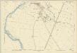
Huntingdonshire XXV.15 (includes: Eaton Socon; Eynesbury Hardwicke; Eynesbury; St Neots Rural; St Neots) - 25 Inch Map
1 : 2500 Topographic maps Ordnance Survey Ordnance Survey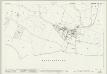
Huntingdonshire XXV.6 (includes: Eaton Socon; Hail Weston; Little Paxton) - 25 Inch Map
1 : 2500 Topographic maps Ordnance Survey Ordnance Survey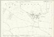
Huntingdonshire XXV.6 (includes: Eaton Socon; Hail Weston; Little Paxton) - 25 Inch Map
1 : 2500 Topographic maps Ordnance Survey Ordnance Survey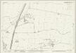
Huntingdonshire XXV.8 (includes: Great Paxton; Little Paxton; St Neots Rural; St Neots; Toseland) - 25 Inch Map
1 : 2500 Topographic maps Ordnance Survey Ordnance Survey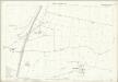
Huntingdonshire XXV.8 (includes: Great Paxton; Little Paxton; St Neots Rural; St Neots; Toseland) - 25 Inch Map
1 : 2500 Topographic maps Ordnance Survey Ordnance Survey
Huntingdonshire XXV.8 (includes: Great Paxton; Little Paxton; St Neots Rural; St Neots; Toseland) - 25 Inch Map
1 : 2500 Topographic maps Ordnance Survey Ordnance Survey
The county of Bedford, 2
1 Blatt : 53 x 72 cm s.n.