Maps of Westvoorne
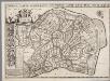
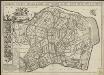
Polder de Noordsluis, gemeente Brielle, Oostvoorne en Rockanje.
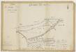
Caarte vande polders van Oud en Nieuw Roc-anje
1 : 5000 A. Steyaart invenit I. Stemmers sculpsit ; I. Luiken fecit cum aqua forti. [S.l.] : [s.n.]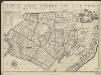
Caarte vande polder van Oost Voorn.
1 : 5000 A. Steyaart invenit I. Stemmers sculpsit ; I. Luiken fecit cum aqua forti [S.l.] : [s.n.]
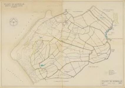
Polder Oostvoorne, gemeente Oostvoorne.
Oud- en Nieuw-Rockanje, Strijpe, Lodderland en Stuifakker, gemeente Rockanje.

Polder Rugge, gemeente Oostvoorne.
Caarte vande polder vande Nieuwe-Goote, Ao. 1696 / A. Steyaart invenit ; I. Stemmers sculpsit ; I. Luiken fecit cum aqua forti
1 : 5000 Annotatie: Uit: Voorne : caert-boeck van alle de dorpen ... (nr. VII); Annotatie geografische gegevens: Met schaalstok A. Steyaart; Jan Stemmers fl. 1695-1734; Jan Luyken 1649-1712; Heyman van Dyck [S.l. : s.n.]
Nieuwe-Goote, gemeente Nieuwenhoorn.
Caarte vande polder vande Nieuwe-Goote, Ao. 1696
1 : 5000 A. Steyaart invenit I. Stemmers sculpsit ; I. Luiken fecit cum aqua forti. [S.l.] : [s.n.]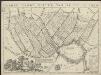
Caarte vande polder van Rugge A° 1696.
1 : 5000 A. Steyaart invenit I. Luiken fecit cum aqua forti ; Heyman van Dyck fecit [S.l.] : [s.n.]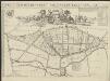
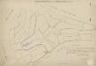
Caarte der heerlycheyt van Naters ende Pancras Gors
1 : 5000 A. Steyaart invenit I. Stemmers sculpsit ; I. Luiken fecit cum aqua forti. [S.l.] : [s.n.]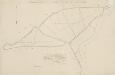
Polder Naters en Pancrasgors, gemeente Rockanje.
Caarte vande polders van Klein Oosterland en Kley-Burgh
1 : 4000 A. Steyaart invenit I. Stemmers sculpsit ; I. Luiken fecit cum aqua forti. [S.l.] : [s.n.]
Polder Klein-Oosterland, gemeente Oostvoorne.
Polder Kruiningergors, gemeente Oostvoorne.
Caarte van Ste. Anna Polder ende 't Schape Gors
1 : 5000 H. vander Dyck fecit A. Steyaart invenit ; I. Stemmers sculpsit ; I. Luiken fecit cum aqua forti. [S.l.] : [s.n.]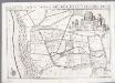
Caarte van Ste. Anna Polder ende 't Schape Gors / A. Steyaart invenit ; I. Stemmers sculpsit ; I. Luiken fecit cum aqua forti
Annotatie: Uit: Voorne : caert-boeck van alle de dorpen ... (nr. XII) Steyaart, A.; Stemmers, I.; Jan Luyken 1649-1712 [S.l. : s.n.]
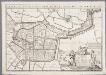
Briela.
1 : 3000 Te Amsterdam : by I. Cóvens & C. Mortier
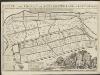
Briela
1 : 10000 Annotatie: Uit: Beschryvingh der Neder-landen; soo uyt Louis Guicciardyn als andere vermaerde schrijvers ... - Amsterdam : Jacob van Meurs, 1660 [Amsterdam : Jacob van Meurs]
BRIELA.
[Amsterdam : Joan Blaeu]
Noor-Meeuwenoordsche polder, gemeente Brielle.

Krabbe Buitenpolder, gemeente Rozenburg.
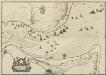
De mont van de Maes : met een op rechte af-beeldinge van alle de actien die bij het Postjacht, de loots boots en andere schepen in het uijt en in seilen oock van het posthuijs en postillions werden gedaen
1 : 14000 int licht gebracht door Jacob Quacq, postmeester der stadt Rotterdam. [S.l.] : [S.n.]
St-Annapolder en Schapengors, gemeente Rockanje.

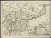
Caarte vande Vier Polders anno 1696
1 : 12500 A. Steyaart invenit I. Stemmers sculpsit ; I. Luiken fecit cum aqua forti. [S.l.] : [s.n.]
Vierpolders, gemeente Vierpolders, Heenvliet, Brielle, Hellevoetsluis en Zwartewaal.

Polder de Quack, gemeente Nieuw-Helvoet.

Krabbenpolder, gemeente Rozenburg.
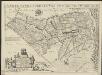
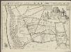
Generale caarte vanden lande van Voorne aande oost zyde van Flacquee.
1 : 23000 A. Steyaart invenit I. Stemmers sculpsit ; I. Luiken fecit cum aqua forti [S.l.] : [s.n.]