Maps of Hochsauerlandkreis

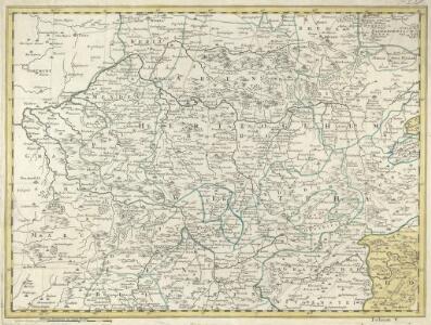
Delineatio Geographica generalis comprehendens VI. Foliis Singulos Principatvs Comitatvs Ditiones Dynastias omnes quotquot Imperio Serenissimi Principis Landgrafii Hasso-Darmstadiensis subsunt :
1 : 180000 Mollova mapová sbírka Bronner, Christian Maximilian Homann, Johann Baptista - dědici
Le Duché de Westphalie
1 : 250000 Mollova mapová sbírka Sanson, Guillaume Covens, Johannes I
Le Duché de Westphalie
1 : 250000 Mollova mapová sbírka Sanson, Guillaume Jaillot, Alexis Hubert
Le Duché de Westphalie
1 : 250000 Mollova mapová sbírka Sanson, Guillaume Jaillot, Alexis Hubert
WESTPHALIA | Ducatus
[Amsterdam : Joan Blaeu]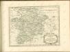

Westphalia Dvcatvs
1 : 270000 Mollova mapová sbírka Valk, Gerhard Schenk, Peter I
Westphalia Dvcatvs
1 : 270000 Mollova mapová sbírka Janssonius, Johannes Janssonius, Johannes I
Ducatus Westphalia
1 : 227000 Vestfálsko (Německo) Seutter, Matthäus sumtibus Matthaei Seutteri
110. Arnsberg, uit: Topographische Uebersichtskarte des Deutschen Reiches / herausgegeben v. d. Kartogr. Abt. d. Königl. Preuß. Landesaufnahme
1 : 200000 titelvariant: Topogr. Übersichtskarte des Deutschen Reiches; Annotatie: Titel boven bladen ook: Topogr. Übersichtskarte des Deutschen Reiches; Annotatie geografische gegevens: Op elk blad twee maatstokken: 10 Kilometer = 5,5 cm; 1 geogr. Meile = 3,6 cm; Legenda onder op elk blad Königlich Preußische Landesaufnahme. Kartographische Abtheilung [S.l : Königlich Preußische Landesaufnahme, Kartographische Abtheilung]
Waldeck Comitatvs
1 : 190000 Mollova mapová sbírka Valk, Gerhard Schenk, Peter II
Waldeck Comitatus
1 : 220000 Mollova mapová sbírka Mercator, Gerhard Mercator, Gerard
Ducatus Westphaliae Cum annexis
1 : 270000 Mollova mapová sbírka Gigas, Johann Michael Gigas, Johannes
Ducatus Westphaliae Cum annexis
1 : 270000 Mollova mapová sbírka Gigas, Johann Michael Gigas, Johannes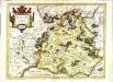
Waldeck comitatus
1 Karte : Kupferdruck ; 34 x 44 cm Hondius; Mercator Henricus Hondius
Waldeck comitatus
1 Karte : Kupferdruck ; 34 x 44 cm Mercator s.n.
Meßtischblatt 4817 : Hallenberg, 1945
1 : 250000 Hallenberg / hrsg. vom OKH/Gen St d H. - Stand 1938, bericht. 1943, hrsg. 1944, gedr. [19. - 1:25000. - [Berlin]: Reichsamt für Landesaufnahme, 1945. - 1 Kt.
Meßtischblatt 4816 : Girkhausen, 1938
1 : 250000 Girkhausen. - Stand 1938. - 1:25000. - [Berlin]: Reichsamt für Landesaufnahme, 1938. - 1 Kt.
Meßtischblatt 2788 : Schmallenberg, 1896
1 : 250000 Schmallenberg. - Aufn. 1894. - 1:25000. - [Berlin]: Reichsamt für Landesaufnahme, 1896. - 1 Kt.
Meßtischblatt 4813 : Attendorn, 1950
1 : 250000 Attendorn. - Aufn. 1896, hrsg. 1896, letzte Nachtr. 1927. - 1:25000. - [Bonn-Bad Godesberg]: LVA NW, 1950. - 1 Kt.
Meßtischblatt 2787, neue Nr. 4814 : Altenhundem, 1936
1 : 250000 Altenhundem. - Hrsg. 1896, einz. Nachtr. 1927, gedr. [19]36. - 1:25000. - [Berlin]: Reichsamt für Landesaufnahme, 1936. - 1 Kt.
Meßtischblatt 2785 : Herscheid, 1927
1 : 250000 Herscheid. - Aufn. 1894, bericht. 1927. - 1:25000. - [Berlin]: Reichsamt für Landesaufnahme, 1927. - 1 Kt.
Meßtischblatt 2785 : Herscheid, 1919
1 : 250000 Herscheid. - Aufn. 1894, hrsg. 1896, Nachtr. 1919. - 1:25000. - [Berlin]: Reichsamt für Landesaufnahme, 1919. - 1 Kt.
Meßtischblatt 2785 : Herscheid, 1896
1 : 250000 Herscheid. - Aufn. 1894. - 1:25000. - [Berlin]: Reichsamt für Landesaufnahme, 1896. - 1 Kt.
Meßtischblatt 2784 : Meinerzhagen, 1921
1 : 250000 Meinerzhagen. - Aufn. 1894, Nachtr. 1921. - 1:25000. - [Berlin]: Reichsamt für Landesaufnahme, 1921. - 1 Kt.
Meßtischblatt 2730 : Goddelsheim, 1900
1 : 250000 Goddelsheim. - Aufn. 1898. - 1:25000. - [Berlin]: Reichsamt für Landesaufnahme, 1900. - 1 Kt.
Meßtischblatt 2729 : Niedersfeld, 1900
1 : 250000 Niedersfeld. - Aufn. 1898, hrsg. 1900, bericht. 1906. - 1:25000. - [Berlin]: Reichsamt für Landesaufnahme, 1906. - 1 Kt.
Meßtischblatt 2728 : Bödefeld, 1900
1 : 250000 Bödefeld. - Aufn. 1898. - 1:25000. - [Berlin]: Reichsamt für Landesaufnahme, 1900. - 1 Kt.
Meßtischblatt 2727 : Eslohe, 1896
1 : 250000 Eslohe. - Aufn. 1894. - 1:25000. - [Berlin]: Reichsamt für Landesaufnahme, 1896. - 1 Kt.