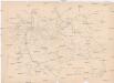
Maps of Meurthe-et-Moselle

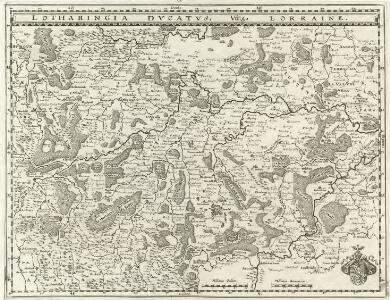
Lotharingia Dvcatvs Vulgo Lorraine
1 : 620000 Mollova mapová sbírka Merian, Matthaeus Merian, Matthäus

Lotharingia Ducatus; Vulgo Lorraine. [Karte], in: Novus Atlas, das ist, Weltbeschreibung, Bd. 2, S. 66.
1 Karte aus Atlas Blaeu, Joan Blaeu, Willem Janszoon
LOTHARINGIA DVCATVS; Vulgo LORRAINE
Amsterdami | Apud Guiljelmum Blaeuw
Lotharingia Ducatus: Vulgo Lorraine. [Karte], in: Theatrum orbis terrarum, sive, Atlas novus, Bd. 2, S. 47.
1 Karte aus Atlas Blaeu, Joan Blaeu, Willem Janszoon
Lotharingia Ducatus; Vulgo Lorraine. [Karte], in: Le théâtre du monde, ou, Nouvel atlas contenant les chartes et descriptions de tous les païs de la terre, Bd. 2, S. 66.
1 Karte aus Atlas Blaeu, Willem Janszoon und Blaeu, Joan Blaeu, Willem Janszoon
Lotharingia ducatus
1 Karte : Kupferdruck ; 29 x 37 cm Sandrart Jacob Sandrart excudit
Lotharingia dvcatvs; vulgo Lorraine
1 Karte : Kupferdruck ; 26 x 36 cm Merian
Lotharingia dvcatvs; vulgo Lorraine
1 Karte : Kupferdruck ; 34 x 49 cm Blaeu apud Guiljelmum Blaeuw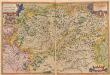
Lorraine. Lotharingiae Nova Descriptio. [Karte], in: Theatrum orbis terrarum, S. 93.
1 Karte aus Atlas Ortelius, Abraham
Les duchez de Lorraine et de Bar les evechez de Metz, Toul, et Verdun
1 : 400000 Bar-le-Duc (Francie) Fer, Nicolas de Starckman, P. N. de Fer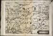
Lotharingia
1 Karte : Kupferdruck ; 15 x 20 cm Lambert Andreae
Lotharingia dvcatvs noua descriptio
1 Karte : Kupferdruck ; 41 x 53 cm Janssonius apud Ioannem Ianssonium
Les Duchez de Lorraine et de Bar les Evechez de Metz, Toul, et Verdun
1 : 390000 Mollova mapová sbírka Fer, Nicolas de Starckman, P. Fer, Nicolas de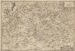
Lorraine. Lotharingiae Nova Descriptio. [Karte], in: Theatrum orbis terrarum, S. 150.
1 Karte aus Atlas Ortelius, Abraham Vrients, Jan Baptista
Sheet 3, uit: Stanford's large scale map of the seat of war / Stanford's Geographical Estab[lishmen]t
1 : 300000 Stanford's Geographical Establishment, Londen London : Stanford
Les estats, du duc de Lorraine ou sont les duchez de Lorraine et de Bar
1 : 177000 Lotrinsko (Francie) Jaillot, Alexis-Hubert S. Taillot
Lotharingia Dvcatvs; Vulgo Lorraine
1 : 45000 Mollova mapová sbírka Blaeu, Willem Janszoon Blaeu, Willem Jansz.
Lotharingia Ducatus
1 : 610000 Mollova mapová sbírka Sandrart, Jakob von Sandrart, Jacob von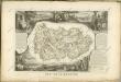

Civitas Leucorum sive pagus Tullensis
1 Karte : Kupferdruck ; 46 x 57 cm L'Isle chez I. Cóvens et C. Mortier
Civitas Leucorum sive pagus Tullensis
1 Karte : Kupferdruck ; 47 x 59 cm L'Isle chez l'auteur sur le quai de l'Horloge
Civitas Leucorum sive Pagus Tullensis aujourdhui le diocese de Toul
1 : 300000 Delisle, Guillaume I. Covens et C. Mortier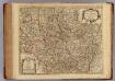
Civitas Leucorum, Diocese de Toul.
1 : 303000 L'Isle, Guillaume de, 1675-1726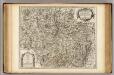
Civitas Leucorum, Diocese de Toul.
1 : 303000 L'Isle, Guillaume de, 1675-1726
Lotharingia Dvcatvs Noua descriptio
1 : 48000 Mollova mapová sbírka Janssonius, Johannes Janssonius, Johannes I
Département de la Meurte
1 Karte : Kupferdruck ; 48 x 48 cm Houdan au bureau de l'atlas national rue de la Harpe no. 26, et au dépôt du dit atlas rue de la Monnoye no. 5
[Atlas départemental : La France et ses colonies] No. 53 Meurthe
1 : 670000 publ. par Michel fils ainé [dressé par A. Lorrain, et gravé par H. Dandeleux] Versailles [etc.] : Barreswil et Andrieux
Skizze der Bewegungen der deutschen und französischen Armeen vom 7. bis 14. August
1 : 490000 Francie