Maps of Brandenburg

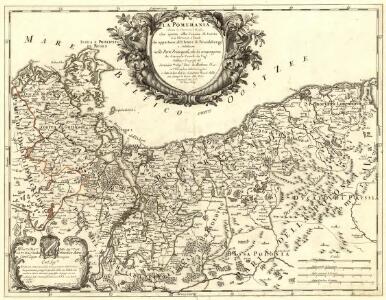
La Pomerania divisa in Citeriore, o Reale che spetta alla Corona di Suezia et in Vlteriore , o Ducale che appartiene all ́Elettore di Brandeburgo e Subdiuisa nelle Parti Principali, che la compognono
1 : 700000 Mollova mapová sbírka Cantelli, Giacomo De Rossi, Giovanni Giacomo
Charte über den nördlichen Theil des ober saechsischen Kreises enthaltend die Mark Brandenburg u. d. Hrz. Pom[m]ern
1 Karte : Kupferdruck ; 46 x 59 cm Güssefeld im Verlage des Industrie Comptoirs
Der nördliche Theil des Ober Sächsischen Kreises oder die Mark Brandenburg und das Herzogthum Pommern
1 : 880000 Braniborsko (Německo) Güssefeld, Franz L. von den Homan[n] Erben
Der nördliche Theil des Ober-Sächsischen Kreises oder die Mark Brandenburg und das Herzogthum Pommern
1 : 880000 Braniborsko (Německo) Güssefeld, Franz L. Schmidt, I.M. von den Homann. Erben
Der nördliche Theil des Ober Sächsischen Kreises oder die Mark Brandenburg und das Herzogthum Pommern
1 : 880000 Braniborsko (Německo) Güssefeld, Franz L. von den Homan[n] Erben
Marchionatus Brandenburgi et Ducatus Pomeraniae Tabula Quae est pars Septentrionalis Circuli Saxoniae Superioris
1 : 1000000 Mollova mapová sbírka Wit, Frederik de Wit, Frederick
Marchionatus et Electoratus Brandeburgicus, una et Ducatus Pomeraniae in suas subdivisi Ditiones Atque noviter descripti
1 : 970000 Mollova mapová sbírka Valk, Gerhard Valck, Gerard
Marchionatus Brandenburgensis in quo sunt Vetus Media et Nova Marchia et Ducatus Pomeraniae Tabula Quae est pars Septentrionalis Circuli Saxoniae Superioris
1 : 870000 Mollova mapová sbírka Danckerts, Theodorus Danckerts, Theodor

Brandenburg und Pommern
Allgemeiner Atlas [Walch, Johannes] im Verlag bei Johannes Walch
Marchionatus Brandenburgensis in quo sunt Vetus, Media et Nova Marchia et ducatus Pomeraniae tabula
1 : 870000 1 Karte : Kupferdruck ; 48 x 57 cm Danckerts, Theodorus [Danckerts]
Karte der Mark Brandenburg und des Herzogthums Pommern
Neuester Schul-Atlas Walch, Johann im Verlag bei Joh. Walch
Marchionatus Brandenburgensis ducatus Pomeraniae et ducatus Mecklenburgicus excusi et venales prostantes
1 : 880000 Braniborsko (Německo) Lotter, Tobias Conrad T. C. Lotter
Marchionatus Brandenburgensis ducatus Pomeraniae et ducatus Mecklenburgicus excusi et venales prostantes
1 : 880000 Braniborsko (Německo) Lotter, Tobias Conrad T. C. Lotter
Marchionatus Brandenburgensis ducatus Pomeraniae et ducatus Mecklenburgicus
1 : 880000 Braniborsko (Německo) Seutter, Matthäus apud Matthaeum Seutter
Tabvla marchionatvs Brandenbvrgici et dvcatvs Pomeraniae quae sunt pars septentrionalis circvli Saxoniae svperioris
1 : 1072000 Braniborsko (Německo) Homann, Johann Baptist a Ioh. Baptista Homanno
Tabvla marchionatvs Brandenbvrgici et dvcatvs Pomeraniae quae sunt pars septentrionalis circvli Saxoniae svperioris
1 : 1072000 Braniborsko (Německo) Homann, Johann Baptist a Ioh. Baptista Homanno
Tabvla marchionatvs Brandenbvrgici et dvcatvs Pomeraniae quae sunt pars septentrionalis circvli Saxoniae svperioris
1 : 1070000 Braniborsko (Německo) Homann, Johann Baptist a Ioh. Baptista Homanno
Marchionatus Brandenburgicus, et Ducatus Pomeraniae
1 : 730000 Mollova mapová sbírka Valk, Gerhard Valck, Gerard
Brandenburg und Pommern
1 : 1151000 Braniborsko (Německo) Jättnig, Wilhelm Gleditsch
Marchionatus et Electoratus Brandeburgicus, una et Ducatus Pomeraniae in suas subdivisi ditiones
1 : 1000000 Mollova mapová sbírka Valk, Gerhard
Le Duché de Pomeranie divisé en ses Principales Parties
1 : 550000 Mollova mapová sbírka Sanson, Guillaume Covens, Johannes I
Le Duché de Pomeranie , compris sous le Cercle de la Haute Saxe, divisé suivant quil est presentement partagé entre la Couronne de Suede, et l'Eslecteur de Brandebourg ou sont Les Duchés de Pomeranie, de Stettin, de Wolgast, de Bardt, de Cassubie, et de Vandalie, la Principauté et Isle de Rugen, le Comté de Gutzkow, les Seigneuries de Louwenboch et de Butow
1 : 675000 Mollova mapová sbírka Sanson, Guillaume Jaillot, Alexis Hubert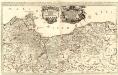
Das Herzogthum Pommern, wie es theil der Cron Schweden, theils Chur-Brandenburg zugehörig
1 : 550000 Mollova mapová sbírka Sanson, Guillaume Hoffmann, Johann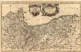
Le Duché de Pomeranie divisé en ses Principales Parties
1 : 550000 Mollova mapová sbírka Sanson, Guillaume Jaillot, Alexis Hubert
Marchionatus Brandenburgensis Ducatus Pomeraniae et Ducatus Macklenburgicus
1 : 870000 Mollova mapová sbírka Seutter, Matthäus Seutter, Matthäus
Circvli Saxoniae Svperioris Pars Septentrionalis, complectens Electorat. Brandenburg et Duc. Pomeraniae
1 : 2800000 Mollova mapová sbírka Franz, Johann Michael Homann, Johann Baptista - dědici
A map of Upper Saxony comprehending that part of Germany which is the present seat of war
1 : 2534400
Carte Generale d'Allemagne
1 : 1300000 Mollova mapová sbírka Eisenschmidt, Johann Caspar Julien, Roch Joseph