Maps of Sant'Olcese
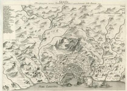
Genova Fortificazioni nuove Territorio, marchie, è appostamenti delle Armate
1 : 30000 Mollova mapová sbírka
Operations Plan der Kay; Armee vor Genua
Mollova mapová sbírka Lidl, Johann Jakob Lidl, Johann Jacob
Carte géometrique de la ville et des environs de Gene : ou on voit l'expedition des Imperiaux et Piemontois contre le Genois et leurs alliez avec les differents postes, retranchements, attaques, déffenses, et mouvements de deux parties, le tout deßine sur le lieux, et de la maniere la plus exacte dans l'année 1747
1 : 38980 s.n.
Carte Particuliere des Environs de Genes
1 : 120000 Mollova mapová sbírka Dheulland, Guillaume Dheulland, Guillaume
Town plan of Genoa (Genova)
1 : 10000 Great Britain. War Office. General Staff. Geographical Section Army Map Service, U.S. Army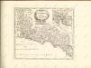

Riviera di Genova di Levante
1 : 290000 Janov (Itálie) Janssonius, Johannes Ioannes Ianssonius

RIVIERA DI | GENOVA | DI LEVANTE
[Amsterdam : Joan Blaeu]
Riviera Di Genova Di Levante
1 : 270000 Mollova mapová sbírka Magini, Fabio Magini, Fabio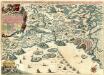
Wahrhaffter Grund-Riß der Stadt Genua
Mollova mapová sbírka Baeck, Elias Bäck, Elias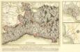
Kriegs- Schau- Platz in Italien in der Republic Genua
1 : 220000 Mollova mapová sbírka Lidl, Johann Jakob Lidl, Johann Jacob
Historia Belli in Italia A. 1746. :
1 : 320000 Mollova mapová sbírka Homann, Johann Baptist Homann, Johann Baptista - dědici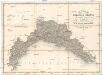
Carta del ducato di Genova
1 : 250000 Janov-oblast (Itálie) Cordero, G. Doyen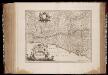
Riviera di Genova di Levante
1 : 270000 Annotatie: Origineel is Blad 157 in atlas factice; Annotatie geografische gegevens: Schaalstokken: Milliaria Italica communia, en: Milliaria Germanica communia Amstelodami : Excudebat Ioannes Ianssonius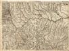
Environ de Novare et de Mortara = Environs de Lodi Pavie et Plaisance
1 : 120000 Mollova mapová sbírka Dheulland, Guillaume Dheulland, Guillaume
Territorio Di Pavia, Lodi, Novarra, Tortona, Alessandria et altri vicini dello Stato di Milano. [Karte], in: Novus atlas absolutissimus, Bd. 5, S. 77.
1 Karte aus Atlas Janssonius Offizin
Lo stato della repubblica di Genova
Janov-oblast (Itálie) Lotter, Tobias Conrad Doyen da Tobia Cunrado Lottero
Lo Stato della republica di Genova
Janov (Itálie) Lotter, Tobias Conrad da Tobia Conrado Lottero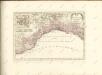

Carta Geographica, la quale rappresenta lo Stato della Republica di Genova partita nella Riviera di Levante et di Ponente
1 : 460000 Mollova mapová sbírka Homann, Johann Baptist Homann, Johann Baptista - dědici
Lo Stato della Repubblica di Genova
1 : 400000 giusta la di lui divisione in contorno orientale et occidentale geograficamente rappresentato et di nuovo dato in luce da Tobia Cunrado Lottero Augusta : [Tobias Conrad Lotter]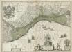
La Republique de Genes.
1 : 610000 Mollova mapová sbírka Blaeu, Willem Janszoon Covens, Johannes I

Nouvelle carte de l'etat de la republique de Genes
1 : 617000 Bastia (Francie) Ottens, Josua R. et I. Ottens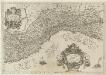
Ligvria Ò Stato Della Republica di Genoua
1 : 650000 Mollova mapová sbírka Magini, Fabio Magini, Fabio
MAPPA GEOGRAPHICA STATVS GENVENSIS
1 : 460000 Janov-oblast (Itálie) Mayer, Tobias Chafrion, José in lucem proferentibus Homannianis Heredibvs
MAPPA GEOGRAPHICA STATVS GENVENSIS
1 : 460000 Janov-oblast (Itálie) Mayer, Tobias Chafrion, José in lucem proferentibus Homannianis Heredibvs
Status Reipublicae Genuensis
1 : 600000 Mollova mapová sbírka Homann, Johann Baptist Homann, Johann Baptista - dědici