Maps of Marcaria

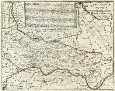
Territoire du Comte et du Diocese de Cremone Qui fait Partie des E'tats du Duché de Milan Au Roy d'Espagne
Mollova mapová sbírka Nolin, Jean-Baptiste Nolin, Jean Baptiste
Carta d ́Italia

La nobiliss.a citta di Piacenza
Piacenza (Itálie) Florimi, Matteo Matteo florimi
Territoire de Cremona
1 : 200000 Mollova mapová sbírka Mortier, Pieter Mortier, Pierre
Territorio di Cremona
1 : 220000 Mollova mapová sbírka Magini, Giovanni Antonio Magini, Giovanni Antonio
Agri Cremonensis typvs
1 Karte : Kupferdruck ; 33 x 48 cm Campi; Ortelius s.n.
Territorio di Cremona
1 : 230000 Mollova mapová sbírka Schenk, Pieter Schenk, Peter I

TERRITORIO | DI | CREMONA.
[Amsterdam : Joan Blaeu]
Lodi, Cremona, Piacenza
1 : 95750 [S.l. : s.n.]
Lodi, Cremona, Piacenza
Lodi (Itálie) Stanich, Eugen Simonyi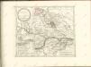

Carta delli Contorini di Mantoua nella quale si vede tutto il Seraglio et una Parte de Veronese
1 : 130000 Mollova mapová sbírka Merz, Johann Georg Merz, Johann Georg
Theatrum Belli per Italiam Ao. MDCCXXXIV
1 : 290000 Mollova mapová sbírka Seutter, Matthäus Seutter, Matthäus
Plan des verschanzten Lagers von Piacenza
Piacenza (Itálie)
Territorio Di Cremona. [Karte], in: Theatrum orbis terrarum, sive, Atlas novus, Bd. 3, S. 70.
1 Karte aus Atlas Blaeu, Joan Blaeu, Willem Janszoon
Territorio Di Cremona. [Karte], in: Le théâtre du monde, ou, Nouvel atlas contenant les chartes et descriptions de tous les païs de la terre, Bd. 3, S. 72.
1 Karte aus Atlas Blaeu, Willem Janszoon und Blaeu, Joan Blaeu, Willem Janszoon
Territoria Di Cremona. [Karte], in: Novus Atlas, das ist, Weltbeschreibung, Bd. 3, S. 84.
1 Karte aus Atlas Blaeu, Joan Blaeu, Willem Janszoon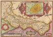
Agri Cremonensis Typus. [Karte] Cremae Ditionis Descriptio. [Nebenkarte], in: Theatrum orbis terrarum, S. 201.
1 Karte aus Atlas Ortelius, Abraham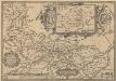
Agri Cremonensis Typus. [Karte] Cremae Ditionis Descriptio. [Nebenkarte], in: Theatrum orbis terrarum, S. 296.
1 Karte aus Atlas Ortelius, Abraham Vrients, Jan Baptista
Territorio di Cremona [Karte], in: Novus atlas absolutissimus, Bd. 5, S. 80.
1 Karte aus Atlas Janssonius Offizin
Le Cours du Po dans le Milanez
1 : 250000 Mollova mapová sbírka Placide de Sainte-Hélène Berey, Charles Amadeus de

Ducato di Parma et di Piacenza [Karte], in: Theatrum orbis terrarum, sive, Atlas novus, Bd. 3, S. 79.
1 Karte aus Atlas Blaeu, Joan Blaeu, Willem Janszoon
Ducato di Parma et di Piacenza [Karte], in: Le théâtre du monde, ou, Nouvel atlas contenant les chartes et descriptions de tous les païs de la terre, Bd. 3, S. 81.
1 Karte aus Atlas Blaeu, Willem Janszoon und Blaeu, Joan Blaeu, Willem Janszoon
Ducato di Parma et di Piacenza [Karte], in: Novus Atlas, das ist, Weltbeschreibung, Bd. 3, S. 93.
1 Karte aus Atlas Blaeu, Joan Blaeu, Willem Janszoon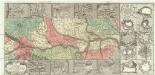
Theatrum belli per Italiam a. 1734
1 : 350000 Itálie severní Seutter, Matthäus M. Seutter
Ducato di Parma, et di Piacenza. [Karte], in: Novus atlas absolutissimus, Bd. 5, S. 136.
1 Karte aus Atlas Janssonius Offizin
Ducato Di Parma Et Di Piacenza [Karte], in: Gerardi Mercatoris et I. Hondii Newer Atlas, oder, Grosses Weltbuch, Bd. 2, S. 288.
1 Karte aus Atlas Mercator, Gerhard und Hondius, Jodocus Jansson, Jan