Maps of Kolín

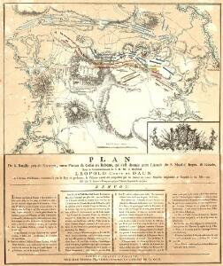
Plan De la Bataille près de Krzeczor, entre Planian & Collin en Bohème, qui s'est donnée l'Armée de S. Majesté Imper. & Royale
Mollova mapová sbírka Trattner, Johann Thomas von
Bez titulu: Bitva u Kolína 18. června 1757
Bojiště u Kolína v podobě před sto lety
1 : 55000 Kolín-oblast (Česko)
Wahrhaffter Entwurff der bey Chotzemitz zwischen der kaiserlichen und koenio. [sic] preüss. Armee vorgefallenen Haubt-Bataille den 18ten Juny A. 1757
Kolín-oblast (Česko) Dilling Mentzel, J. G.
Neu Kollin (Nowy Kolin) - c3283-1-002 - Kaiserpflichtexemplar der Landkarten des stabilen Katasters
1 : 2880
Neu Kollin (Nowy Kolin) - c3283-1-007 - Kaiserpflichtexemplar der Landkarten des stabilen Katasters
1 : 2880
Neu Kollin (Nowy Kolin) - c3283-1-008 - Kaiserpflichtexemplar der Landkarten des stabilen Katasters
1 : 2880
Neu Kollin (Nowy Kolin) - c3283-1-006 - Kaiserpflichtexemplar der Landkarten des stabilen Katasters
1 : 2880
Neu Kollin (Nowy Kolin) - c3283-1-004 - Kaiserpflichtexemplar der Landkarten des stabilen Katasters
1 : 2880
Neu Kollin (Nowy Kolin) - c3283-1-005 - Kaiserpflichtexemplar der Landkarten des stabilen Katasters
1 : 2880
Neu Kollin (Nowy Kolin) - c3283-1-012 - Kaiserpflichtexemplar der Landkarten des stabilen Katasters
1 : 2880
Neu Kollin (Nowy Kolin) - c3283-1-001 - Kaiserpflichtexemplar der Landkarten des stabilen Katasters
1 : 2880
Neu Kollin (Nowy Kolin) - c3283-1-011 - Kaiserpflichtexemplar der Landkarten des stabilen Katasters
1 : 2880
Neu Kollin (Nowy Kolin) - c3283-1-010 - Kaiserpflichtexemplar der Landkarten des stabilen Katasters
1 : 2880
Neu Kollin (Nowy Kolin) - c3283-1-009 - Kaiserpflichtexemplar der Landkarten des stabilen Katasters
1 : 2880
Neu Kollin (Nowy Kolin) - c3283-1-013 - Kaiserpflichtexemplar der Landkarten des stabilen Katasters
1 : 2880
Neu Kollin (Nowy Kolin) - c3283-1-003 - Kaiserpflichtexemplar der Landkarten des stabilen Katasters
1 : 2880
Die grössere östliche Hälfte des Schlachtfeldes bei Kolin
1 : 25000 Kolín (Česko : oblast)
Krzeczhorz (Křečhoř) - c3605-1-001 - Kaiserpflichtexemplar der Landkarten des stabilen Katasters
1 : 2880
Krzeczhorz (Křečhoř) - c3605-1-003 - Kaiserpflichtexemplar der Landkarten des stabilen Katasters
1 : 2880
Krzeczhorz (Křečhoř) - c3605-1-002 - Kaiserpflichtexemplar der Landkarten des stabilen Katasters
1 : 2880
Krzeczhorz (Křečhoř) - c3605-1-005 - Kaiserpflichtexemplar der Landkarten des stabilen Katasters
1 : 2880
Krzeczhorz (Křečhoř) - c3605-1-004 - Kaiserpflichtexemplar der Landkarten des stabilen Katasters
1 : 2880
Chotzenitz (Choceniče) - c2541-1-003 - Kaiserpflichtexemplar der Landkarten des stabilen Katasters
1 : 2880
Chotzenitz (Choceniče) - c2541-1-004 - Kaiserpflichtexemplar der Landkarten des stabilen Katasters
1 : 2880
Chotzenitz (Choceniče) - c2541-1-002 - Kaiserpflichtexemplar der Landkarten des stabilen Katasters
1 : 2880
Chotzenitz (Choceniče) - c2541-1-001 - Kaiserpflichtexemplar der Landkarten des stabilen Katasters
1 : 2880
Situační plán král. města Kolína
1 : 9500 Kolín (Česko) Fr. Šindelíř
Dreihöfen (Třidwory) - c8076-1-001 - Kaiserpflichtexemplar der Landkarten des stabilen Katasters
1 : 2880
Dreihöfen (Třidwory) - c8076-1-003 - Kaiserpflichtexemplar der Landkarten des stabilen Katasters
1 : 2880