Maps of Bezirk Wiener Neustadt
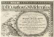
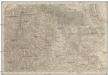
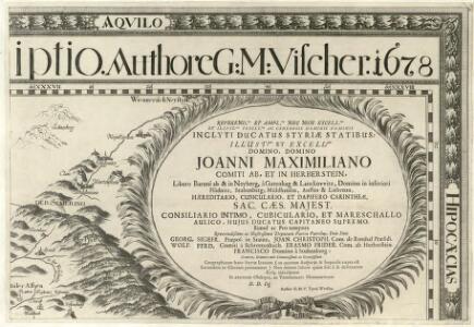
Stÿriae Ducatus Fertilisimi Nova Geographica Descriptio
1 : 200000 Mollova mapová sbírka Vischer, Georg Matthaeus Trost, Andreas
Neunkirchen und Aspang.
from Spezialkarte der osterreichisch-ungarischen Monarchie.
Karte der Schneeberg - Raxalpe - Hochschwab - und Ötscher-Gruppe
1 : 75000 Mürzzuschlag (Rakousko) K. u. k. Militärgeographisches Institut
Schneeberg & Raxalpe
1 : 75000 Alpy rakouské (pohoří) Artaria
Neunkirchen und Aspanc
1 : 75000 Neunkirchen (Niederösterreich, Region), Aspang Markt Geripp: Assistent Jrblich. Terrain: Lieut. Schüller
Neunkirchen und Aspang
1 : 75000 Kartographisches, früher Militärgeographisches Institut
Neunkirchen und Aspang
1 : 75000 Vogel, R. Kartographisches, früher Militärgeographisches Institut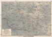
Aspang und Umgebung mit dem Wechsel
1 : 75000 Wechsel (Rakousko : pohoří) Rössler, Johann Anspanger Verschönerungsverein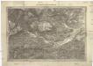
Umgebung von Gloggnitz
1 : 44400 Gloggnitz (Rakousko)
Semmering - Gebiet

Freytag & Berndt's Ausflugskarte
1 : 100000 Alpy rakouské (pohoří : oblast) Kartogr. Anst. Freytag & Berndt
G. Freytag ́s Ausflugskarte
1 : 100000 Rakousko Freytag, Gustav Freytag & Berndt
Situation und Längenprofil der k.k. Staatseisenbahn von Gloggnitz bis Mürzzuschlag über den Semmering
1 : 46000 Lechner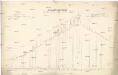
General-Längen-Profil der k. k. Staats-Eisenbahn von Gloggnitz bis Mürzzuschlag
Gloggnitz-Mürzzuschlag (Rakousko : železniční trať)
Umgebung von Bayerbach & Schneeberg
Dolní Rakousko (Rakousko)
Schneeberg, Raxalpe & Semmering
1 : 37500 Südost-Blatt Pauliny, Jacob Josef Pauliny
Spital am Semmering
1 : 25000 Kartographisches Institut
Schneeberg, Raxalpe & Semmering
1 : 37500 Nordost-Blatt Pauliny, Jacob Josef Pauliny
Schneeberg, Raxalpe & Semmering
1 : 37500 Nordwest-Blatt Pauliny, Jacob Josef Pauliny
Karte der Hohen Wand
1 : 25000 Přírodní park Hohe Wand (Rakousko) Kartographisches Institut
Hirschwang
1 : 25000 Kartographisches Institut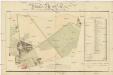
Plan des Thiergartens der k.k. Militair Accademie Wiener Neustadt
1 : 3000 Wiener Neustadt (Rakousko) Zesner Müller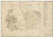
Grundriss des Thiergartens in dem k.k. Militaire Kadeten Haus
1 : 4000 Wiener Neustadt (Rakousko) Szczepanowski, K. Schönerer, Mathias
Schneeberg, Raxalpe & Semmering
1 : 37500 Südwest-Blatt Pauliny, Jacob Josef Pauliny
Plan der Stadt Wiener Neustadt
1 : 5100 Wiener Neustadt (Rakousko) Hochwaldsky
K. k. Neustädter Militär-Academie
1 : 16000 Wiener Neustadt (Rakousko) C. Steingruber
Umgebung von Baaden - Gutenstein - Mürzzuschlag
1 : 129600 Baden (Rakousko) Maschek, Rudolf Artaria
Touristen Wanderkarte der Niederösterr.-Steirischen Alpen und Voralpen
1 : 100000 Freytag, Gustav Artaria
Umgebung von Baaden-Gutenstein-Mürzzuschlag
1 : 129600 Maschek, Rudolf Artaria