Maps of Röbel-Müritz

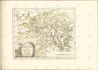
Mappa Ducatus Megalopolitani Nova :
1 : 190000 Mollova mapová sbírka
60. Neustrelitz, uit: Topographische Uebersichtskarte des Deutschen Reiches / herausgegeben v. d. Kartogr. Abt. d. Königl. Preuß. Landesaufnahme
1 : 200000 titelvariant: Topogr. Übersichtskarte des Deutschen Reiches; Annotatie: Titel boven bladen ook: Topogr. Übersichtskarte des Deutschen Reiches; Annotatie geografische gegevens: Op elk blad twee maatstokken: 10 Kilometer = 5,5 cm; 1 geogr. Meile = 3,6 cm; Legenda onder op elk blad Königlich Preußische Landesaufnahme. Kartographische Abtheilung [S.l : Königlich Preußische Landesaufnahme, Kartographische Abtheilung]
Germany/Central Europe 1:100,000, Schwerin
Germany / Central Europe 1:100,000, Series GSGS 4416. Great Britain. War Office. [London] : Ordnance Survey
59. Ludwigslust, uit: Topographische Uebersichtskarte des Deutschen Reiches / herausgegeben v. d. Kartogr. Abt. d. Königl. Preuß. Landesaufnahme
1 : 200000 titelvariant: Topogr. Übersichtskarte des Deutschen Reiches; Annotatie: Titel boven bladen ook: Topogr. Übersichtskarte des Deutschen Reiches; Annotatie geografische gegevens: Op elk blad twee maatstokken: 10 Kilometer = 5,5 cm; 1 geogr. Meile = 3,6 cm; Legenda onder op elk blad Königlich Preußische Landesaufnahme. Kartographische Abtheilung [S.l : Königlich Preußische Landesaufnahme, Kartographische Abtheilung]
151. Malchin. (Germany)
1 : 100000 Reichsamt fur Landesaufnahme
150. Goldberg. (Germany)
1 : 100000 Reichsamt fur Landesaufnahme
Composite: 151. Malchin. (Germany)
1 : 100000 Reichsamt fur Landesaufnahme
183. Malchow. (Germany)
1 : 100000 Reichsamt fur Landesaufnahme
Composite: 182. Parchim. (Germany)
1 : 100000 Reichsamt fur Landesaufnahme
Composite: 97. Butow. (Germany)
1 : 100000 Reichsamt fur Landesaufnahme
152. Neubrandenburg. (Germany)
1 : 100000 Reichsamt fur Landesaufnahme
182. Parchim. (Germany)
1 : 100000 Reichsamt fur Landesaufnahme
Composite: 150. Goldberg. (Germany)
1 : 100000 Reichsamt fur Landesaufnahme
Composite: 184. Neu-Strelitz. (Germany)
1 : 100000 Reichsamt fur Landesaufnahme
Composite: 183. Malchow. (Germany)
1 : 100000 Reichsamt fur Landesaufnahme
184. Neu-Strelitz. (Germany)
1 : 100000 Reichsamt fur Landesaufnahme
Composite: 152. Neubrandenburg. (Germany)
1 : 100000 Reichsamt fur Landesaufnahme
Composite: 215. Rheinsberg. (Germany)
1 : 100000 Reichsamt fur Landesaufnahme
Composite: 214. Wittstock. (Germany)
1 : 100000 Reichsamt fur Landesaufnahme
214. Wittstock. (Germany)
1 : 100000 Reichsamt fur Landesaufnahme
43. Neubrandenburg, uit: Topographische Uebersichtskarte des Deutschen Reiches / herausgegeben v. d. Kartogr. Abt. d. Königl. Preuß. Landesaufnahme
1 : 200000 titelvariant: Topogr. Übersichtskarte des Deutschen Reiches; Annotatie: Titel boven bladen ook: Topogr. Übersichtskarte des Deutschen Reiches; Annotatie geografische gegevens: Op elk blad twee maatstokken: 10 Kilometer = 5,5 cm; 1 geogr. Meile = 3,6 cm; Legenda onder op elk blad Königlich Preußische Landesaufnahme. Kartographische Abtheilung [S.l : Königlich Preußische Landesaufnahme, Kartographische Abtheilung]
215. Rheinsberg. (Germany)
1 : 100000 Reichsamt fur Landesaufnahme
Composite: 213. Perleberg. (Germany)
1 : 100000 Reichsamt fur Landesaufnahme
213. Perleberg. (Germany)
1 : 100000 Reichsamt fur Landesaufnahme
Germany 1:25 000, Penzlin
Sheet 1048 from the map series: 1:25,000. Topographische karte (Messtischblätter). Germany. Reichsamt für Landesaufnahme. Berlin : Reichsamt für Landesaufnahme
Germany 1:25 000, Schwinkendorf
Sheet 853 from the map series: 1:25,000. Topographische karte (Messtischblätter). Germany. Reichsamt für Landesaufnahme. Berlin : Reichsamt für Landesaufnahme
Meßtischblatt 2845 : Himmelpfort, 1944
1 : 250000 Himmelpfort. - Hrsg. 1883. - 1:25000. - [Berlin]: Reichsamt für Landesaufnahme, 1944. - 1 Kt.