Maps of Lancaster

Westmoria Comitatus; Anglice Westmorland. [Karte], in: Theatrum orbis terrarum, sive, Atlas novus, Bd. 4, S. 485.
1 Karte aus Atlas Blaeu, Joan Blaeu, Willem Janszoon
Westmoria Comitatus; Anglice Westmorland. [Karte], in: Theatrum orbis terrarum, sive, Atlas novus, Bd. 4, S. 485.
1 Karte aus Atlas Blaeu, Joan Blaeu, Willem Janszoon
Westmoria Comitatus; Anglice Westmorland. [Karte], in: Le théâtre du monde, ou, Nouvel atlas contenant les chartes et descriptions de tous les païs de la terre, Bd. 4, S. 413.
1 Karte aus Atlas Blaeu, Willem Janszoon und Blaeu, Joan Blaeu, Willem Janszoon
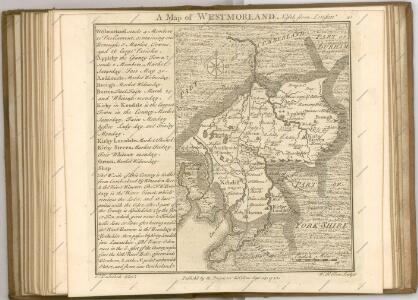
WESTMORIA | COMITATVS; | Anglice | WESTMORLAND.
[Amsterdam : Joan Blaeu]
Westmoria comitatvs; anglice Westmorland
1 Karte : Kupferdruck ; 37 x 48 cm Blaeu Joan Blaeu
Penrith - OS One-Inch Map
1 : 63360 Topographic maps Ordnance Survey Ordnance Survey
The Lake District, Sheet 3 - Bartholomew's "Half Inch to the Mile Maps" of England & Wales
1 : 126720 Topographic maps Bartholomew, John George John Bartholomew & Co
Lancaster and Kendal - OS One-Inch Map
1 : 63360 Topographic maps Ordnance Survey Ordnance Survey
Alston (Outline) - OS One-Inch Revised New Series
1 : 63360 Topographic maps Ordnance Survey Ordnance Survey
Alston (Hills) - OS One-Inch Revised New Series
1 : 63360 Topographic maps Ordnance Survey Ordnance Survey
Brough under Stainmore (Hills) - OS One-Inch Revised New Series
1 : 63360 Topographic maps Ordnance Survey Ordnance Survey
Brough under Stainmore (Outline) - OS One-Inch Revised New Series
1 : 63360 Topographic maps Ordnance Survey Ordnance Survey
Kirkby Stephen (Hills) - OS One-Inch Revised New Series
1 : 63360 Topographic maps Ordnance Survey Ordnance Survey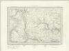
Kirkby Stephen (Outline) - OS One-Inch Revised New Series
1 : 63360 Topographic maps Ordnance Survey Ordnance Survey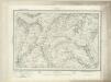
Hawes (Outline) - OS One-Inch Revised New Series
1 : 63360 Topographic maps Ordnance Survey Ordnance Survey
Hawes (Hills) - OS One-Inch Revised New Series
1 : 63360 Topographic maps Ordnance Survey Ordnance Survey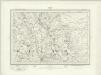
Penrith (Outline) - OS One-Inch Revised New Series
1 : 63360 Topographic maps Ordnance Survey Ordnance Survey
Penrith (Hills) - OS One-Inch Revised New Series
1 : 63360 Topographic maps Ordnance Survey Ordnance Survey
Appleby (Hills) - OS One-Inch Revised New Series
1 : 63360 Topographic maps Ordnance Survey Ordnance Survey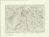
Appleby (Outline) - OS One-Inch Revised New Series
1 : 63360 Topographic maps Ordnance Survey Ordnance Survey
Kendal (Hills) - OS One-Inch Revised New Series
1 : 63360 Topographic maps Ordnance Survey Ordnance Survey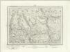
Kendal (Outline) - OS One-Inch Revised New Series
1 : 63360 Topographic maps Ordnance Survey Ordnance Survey
Kirkby Lonsdale (Hills) - OS One-Inch Revised New Series
1 : 63360 Topographic maps Ordnance Survey Ordnance Survey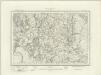
Kirkby Lonsdale (Outline) - OS One-Inch Revised New Series
1 : 63360 Topographic maps Ordnance Survey Ordnance Survey
Wensleydale - OS One-Inch Map
1 : 63360 Topographic maps Ordnance Survey Ordnance Survey
Teesdale - OS One-Inch Map
1 : 63360 Topographic maps Ordnance Survey Ordnance Survey
NY34 - OS 1:25,000 Provisional Series Map
1 : 25000 Topographic maps Ordnance Survey Ordnance Survey
NY33 - OS 1:25,000 Provisional Series Map
1 : 25000 Topographic maps Ordnance Survey Ordnance Survey