Maps of Sarreguemines

Exactissima Tabula Electoratuum Moguntini, Trevirensis et Palatini Episcopatuum Spirensis, et Wormatiensis Comitatuum Sarbruck, Ottweiler Bitsch Sarwerden Falckenstein, Leiningen, Veldentz et Super et Inferior Sponheim.
1 : 240000 Mollova mapová sbírka Person, Nikolaus Person, Nicolas
Neueste Karte und Richtige Vorstellung Aller Städte, Vestungen, Schlösser und remarquablen Ort, welche die Kron Frankreich zwischen dem Rhein, Saar, Mosel und im Elsaß wirklich besitzet
Mollova mapová sbírka Pfann, Wilhelm Ziegerkunst, Johann
Neueste Karte und Richtige Vorstellung Aller Städte, Vestungen, Schlösser und remarquablen Ort, welche die Kron Frankreich zwischen dem Rhein, Saar, Mosel und im Elsaß wirklich besitzet
Mollova mapová sbírka Pfann, Wilhelm
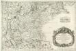
Estats entre la Nied la Sare et le Rhin ou sont la Lorraine allemande le duché de Deux Ponts, les comtés de Bitsche, de Spanheim et de Linange, partie du palatinat meridional l'entrée en Alsace et en Lorraine par les villes de Sarlouis de Hombourg de Landau et leurs environs
1 : 200000 Lotrinsko (Francie) Sengre, Henri Jaillot, Alexis-Hubert Iaillot
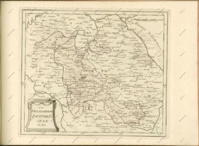
Charte des Baierschen [sic] Rheinkreises
1 : 629000 Bavorsko (Německo) Martin Gleditsch
Charte von dem königlich Bayerschen Kreise des Rhein
1 : 360000 Bavorsko (Německo) Blume, J. A. Pladt
Electorat et Palatinat du Rhein
1 : 190000 Mollova mapová sbírka Fer, Nicolas de Inselin, Charles Danet, Guillaume
Die Pfalz oder Rhein - Bayern
Militair Karte von Süd-Deutschland in 20 Sectionen
1 : 400000 5. Section Coulon, Alois von A. von Coulon
Carte topographique d'Allemagne
1 : 224000 Falc Rýnská Jaeger, Johann Wilhelm Abraham I. W. A. Iaeger

Théatre de la Guerre ou Carte Nouvelle De le Cours du Rhin depuis Strasbourg jusqu'a Worms et Les Pays Adjacens
1 : 250000 Mollova mapová sbírka Delisle, Guillaume Ottens, Josua
[Lotrinsko a Sársko]
Lotrinsko (Francie) Buna, Wilhelm C.

Le Duché de Luxembourg divisé en Quartier Walon et Allemand
1 : 140000 Mollova mapová sbírka Jaillot, Alexis-Hubert Jaillot, Alexis Hubert
Partie Orientale du Palatinat et Eslectorat du Rhein.
1 : 260000 Mollova mapová sbírka Sanson, Guillaume Jaillot, Alexis Hubert
Le Theatre de Bellone :
Mollova mapová sbírka Schenk, Pieter Braakman, Adriaan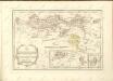
Treveri Archidiacones de Treves, et de Tholey dans le Dioecese de l'Archevesché de Treves.
Mollova mapová sbírka Sanson, Guillaume Sanson, Guillaume
Partie Meridionale Des Pays Qui Sont Situéz Entre Le Rhein, La Saare, La Moselle, Et La Basse Alsace. [Karte], in: Atlas nouveau, contenant toutes les parties du monde [...], Bd. 1, S. 241.
1 Karte aus Atlas Sanson, Nicolas Jaillot, Alexis Hubert und Mortier, Pieter
[Landau - Wissembourg]
1 Blatt : 60 x 90 cm Brunet s.n.
160. Landau, uit: Topographische Uebersichtskarte des Deutschen Reiches / herausgegeben v. d. Kartogr. Abt. d. Königl. Preuß. Landesaufnahme
1 : 200000 titelvariant: Topogr. Übersichtskarte des Deutschen Reiches; Annotatie: Titel boven bladen ook: Topogr. Übersichtskarte des Deutschen Reiches; Annotatie geografische gegevens: Op elk blad twee maatstokken: 10 Kilometer = 5,5 cm; 1 geogr. Meile = 3,6 cm; Legenda onder op elk blad Königlich Preußische Landesaufnahme. Kartographische Abtheilung [S.l : Königlich Preußische Landesaufnahme, Kartographische Abtheilung]
Partie Occidentale du Palatinat et Eslectorat du Rhein
1 : 125000 Mollova mapová sbírka Sanson, Guillaume Jaillot, Alexis Hubert
Trier 112, uit: Special-Karte von Mittel-Europa / nach amtlichen Quellen bearbeitet von W. Liebenow
1 : 300000 titelvariant: W. Liebenow's Mittel-Europa; Annotatie: Titel boven de bladen: W. Liebenow's Mittel-Europa Johannes Wilhelm Liebenow 1822-1897 Frankfurt a. M. : Ludwig Ravenstein
Specialkarte Der Gegenden Zwischen Dem Rhein Und Der Saar
1 : 170000 Rheinwald, Johann Ludwig Christian; Dewarat, Peter; Walbert
Trier 112, uit: [W. Liebenow's Special-Karte von Mittel-Europa]
1 : 300000 titelvariant: W. Liebenow's Mittel-Europa; Annotatie: Titel boven de bladen: W. Liebenow's Mittel-Europa Johannes Wilhelm Liebenow 1822-1897 Hannover : Hermann Oppermann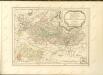

Partie du Cours du Rhein, ou se Trouvent les Villes de Spire Philipsbourg Landau Hagenau et le Fort Louis, Dessigne et Levee sur les Lieues
1 : 160000 Mollova mapová sbírka Baillieul, Gaspard Bailleul, Gaspard